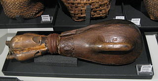
The Haisla are an amalgamation of two bands, the Kitamaat people of upper Douglas Channel and Devastation Channel and the Kitlope People of upper Princess Royal Channel and Gardner Canal in British Columbia, Canada.

Kitimat is a district municipality in the North Coast region of British Columbia, Canada. It is a member municipality of the Regional District of Kitimat–Stikine regional government. The Kitimat Valley is part of the most populous urban district in northwest British Columbia, which includes Terrace to the north along the Skeena River Valley. The city was planned and built by the Aluminum Company of Canada (Alcan) during the 1950s. Its post office was approved on June 6, 1952.

The Nechako River arises on the Nechako Plateau east of the Kitimat Ranges of the Coast Mountains of British Columbia, Canada, and flows north toward Fort Fraser, then east to Prince George where it enters the Fraser River. "Nechako" is an anglicization of netʃa koh, its name in the indigenous Carrier language which means "big river".

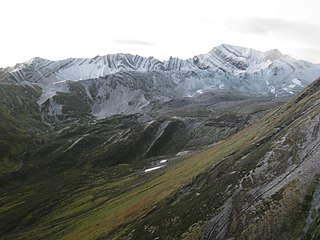
The Kitimat Ranges are one of the three main subdivisions of the Coast Mountains in British Columbia, Canada, the others being the Pacific Ranges to the south and the Boundary Ranges to the north.

The Gardner Canal is one of the principal inlets of the British Columbia Coast. Technically a side-inlet of the larger Douglas Channel, the Gardner Canal is still 90 km (56 mi) in length in its own right; total length of the waterways converging on the Douglas Channel is 320 km (200 mi) making it one of the largest fjord-complexes in the world.
The Skeena Mountains, also known as the Skeenas, are a subrange of the Interior Mountains of northern British Columbia, Canada, essentially flanking the upper basin of the Skeena River. They lie just inland from the southern end of the Boundary Ranges of the Coast Mountains, and also of the northern end of the Kitimat Ranges. Their southern limit is described by the Bulkley River and the upper northwestern reaches of Babine and Takla Lakes, and on their northeast by the upper reaches of the Omineca River.

Kemano was a settlement situated 75 km (47 mi) southeast of Kitimat in the province of British Columbia in Canada. It was built to service a hydroelectric power station, built to provide energy for Alcan to smelt aluminum from its ore. The Kemano Generating Station is built 427 m (1,400 ft) inside the base of Mt Dubose in a blasted cavern. It produces 896 MW of power from its eight generators, each of which has a capacity of 112MW.
The Kenney Dam is a rock-fill embankment dam on the Nechako River in northwestern British Columbia, built in the early 1950s. The impoundment of water behind the dam forms the Nechako Reservoir, which is also commonly known as the Ootsa Lake Reservoir. The dam was constructed to power an aluminum smelter in Kitimat, British Columbia by Alcan, although in the late 1980s the company increased their economic activity by selling excess electricity across North America. The development of the dam caused various environmental problems along with the displacement of the Cheslatta T'En First Nation, whose traditional land was flooded.

The Nechako Reservoir, sometimes called the Ootsa Lake Reservoir, is a hydroelectric reservoir in British Columbia, Canada that was formed by the Kenney Dam making a diversion of the Nechako River through a 16-km intake tunnel in the Kitimat Ranges of the Coast Mountains to the 890 MW Kemano Generating Station at sea level at Kemano to service the then-new Alcan aluminum smelter at Kitimat. When it was constructed on the Nechako River in 1952, it resulted in the relocation of over 75 families. It was one of the biggest reservoirs built in Canada until the completion of the Columbia Treaty Dams and the W.A.C. Bennett Dam that created Lake Williston. The water level may swing 10 feet between 2790 and 2800 feet.
Knewstubb Lake is an arm or stretch of the Ootsa Lake Reservoir in the Nechako Country of the western Central Interior of British Columbia, Canada. It forms part of the south arm of the reservoir, which includes adjoining stretches such as Eutsuk Lake and Natalkuz Lake, which are "upstream" to the southwest. Ootsa Lake was formed by the damming and diversion of the flow of the Nechako River, the bulk of which is now drained beneath the spine of the Coast Mountains to the west to the Kemano Powerhouse, which is the power supply for the aluminum smelter at Kitimat, to the southeast of Terrace.

The Kitlope River is a river in the Kitimat Ranges in the North Coast of British Columbia, Canada, flowing north for 100 km (62 mi), into the head of the Gardner Canal to the south of the smelter town of Kitimat. It is named for the Gitlope group of Haisla, now part of the Haisla Nation government and community at Kitamaat Village near Kitimat. The name is a Tsimshian language reference to the people, who call themselves Henaksiala, and means "people of the rocks" or "people of the opening in the mountains". The Haisla language name for the river is Xesduwaxwsdu.
Kitlope 16, properly the Kitlope Indian Reserve No. 16, is an Indian Reserve on the North Coast of British Columbia, to the south of Kitimat, British Columbia and at the mouth of the Kitlope River, which flows north into the head of the Gardner Canal to the south of that town. It is the home reserve of the Henaksiala or Kitlope or Gitlope group of the Haisla, who are now part of the Haisla Nation government and settled with the Haisla at Kitamaat Village, the reserve community near Kitimat.
The Cheslatta Carrier Nation or Cheslatta T'En, of the Dakelh or Carrier people (Ta-cullies, meaning "people who go upon water", whose traditional lands where originally where the Kitimat Kemano Project I was built, form a large portion of the Central Interior of present-day British Columbia, Canada, is a First Nation of the Nechako River at the headwaters of the Fraser River.
The Cheslatta River is a tributary of the Nechako River, one of the main tributaries of the Fraser River, in the Canadian province of British Columbia. It flows through the Nechako Plateau. Before the construction of Kenney Dam in the early 1950s the Cheslatta was a minor tributary of the Nechako. Today the Nechako River is dry above the Cheslatta, which provides all its source water.
The Kemano Generating Station is situated 75 km (47 mi) southeast of Kitimat in the province of British Columbia, Canada. It was completed in 1954, providing hydroelectricity for Alcan's Kitimat Aluminum smelter. The powerhouse is built in a cavern created 427 m (1,400 ft) inside the base of Mt Dubose. It produces 896 MW of power from its eight generator units, each of which has a capacity of 112 MW. It was the largest producer in the province when it was built, and is now the fifth largest electrical plant in British Columbia.
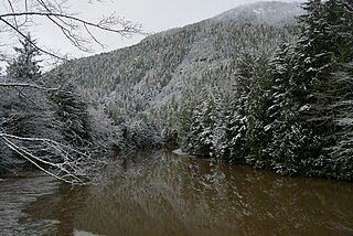
Kiltuish River is a river in the Canadian province of British Columbia. It originates in the Kitimat Ranges, and flows about 25 km (16 mi) north to the Pacific Ocean at Kiltuish Inlet, an arm of the fjord Gardner Canal. The Kiltuish River is within the traditional territory of the Haisla people.

The Bell-Irving River is a tributary of the Nass River in northwestern British Columbia, Canada. It originates in the Sacred Headwaters region, and flows about 165 km (103 mi) south to the Nass River. It course lies between the Oweegee Range of the Skeena Mountains to the east and the Boundary Ranges of the Coast Mountains to the west.
The Ecstall River is a tributary of the Skeena River in the province of British Columbia, Canada. It originates in the Kitimat Ranges, and flows about 110 km (68 mi) to the lower tidal reach of the Skeena River at Port Essington, about 30 km (19 mi) southeast of Prince Rupert, 95 km (59 mi) southwest of Terrace, and 85 km (53 mi) northwest of Kitimat. Its drainage basin covers about 1,485 km2 (573 sq mi) and contains the largest blocks of unlogged land on the north coast of British Columbia, although large-scale industrial logging operations, both active and proposed, have been occurring in the watershed since the 1980s.
The McNeil River is a tributary of the Skeena River in the North Coast Regional District of the province of British Columbia, Canada. It originates at Minerva Lake in the Kitimat Ranges of the Coast Mountains, and flows south about 13 km (8.1 mi) to the lower tidal reach of the Skeena River at Tyee Bank, across the Skeena from Port Essington, about 25 km (16 mi) southeast of Prince Rupert, 95 km (59 mi) southwest of Terrace, and 88 km (55 mi) northwest of Kitimat. Its watershed covers 41.4 km2 (16.0 sq mi), and its mean annual discharge is 4.07 m3/s (144 cu ft/s).

