The Dakotas

Last updated

The Dakotas
Region
Dakotas.svg
North and South Dakota in light green
Country Flag of the United States.svg  United States of America
States Flag of North Dakota.svg  North Dakota
Flag of South Dakota.svg  South Dakota
Admission to Union November 2, 1889 (both North and South Dakota)
Area
  Total147,816 sq mi (382,840 km2)
Population
 (2021) [1]
  Total1,670,324
  Density11/sq mi (4.4/km2)
Demonym Dakotan

The Dakotas is a collective term for the U.S. states of North Dakota and South Dakota. It has been used historically to describe the Dakota Territory, and is still used for the collective heritage, [2] culture, geography, [3] fauna, [4] sociology, [5] economy, [6] [7] and cuisine [8] of the two states.

Contents

Etymology

The name "Dakota" refers to the Dakota people. [9]

History

The territory now known as the Dakotas includes a large portion of the ancestral land of Native American tribes, in particular various tribes of Sioux such as the Dakota people, also known as the Santee Sioux. The United States government stakes its claim to the land through the Louisiana Purchase and Rupert's Land acquisition. The region historically involved a complex series of conflicts between the U.S. government and Native American tribes (and among themselves).

The region was part of the Minnesota and Nebraska territories until 1861. Dakota Territory initially included parts of present day Montana, Nebraska and Wyoming. The fall of 1861 resulted in a poor harvest and was followed by a harsh winter, leading to extreme hardship for the Dakota in the region. Desperate for food and money, they were denied loans by local traders. A series of raids in the spring of 1862 ultimately resulted in Dakota War of 1862 between the U.S. government and the Dakota people. The U.S. won the war, the aftermath which included a mass hanging of 38 people on December 26, 1862, the largest mass execution in U.S. history. The remaining Santee Dakota people were exiled by the U.S. government to the Dakota Territory. [10]

The end of the war did not solve the conflicts between Native Americans and the Americans. Fighting would continue, for example along the Bozeman Trail, until the Treaty of Fort Laramie in 1868. The treaty established the Great Sioux Reservation and "designated the Black Hills as 'unceded Indian Territory' for the exclusive use of native peoples." [11] The subsequent discovery of gold in the Black Hills in 1874 by George Armstrong Custer's Black Hills Expedition, would cause a gold rush and the U.S. to violate the treaty. The Indian Appropriations Act of 1876 went into effect on August 15, 1876. This was referred to as "sell or starve" by the Native Americans and led to the Great Sioux War of 1876. The conflict between the Sioux and miners and the U.S. forces backing them would culminate in the Battle of the Little Bighorn, also known as "Custer's Last Stand", the most significant battle of the war. Despite being a Sioux victory, Battle of the Little Bighorn preceded the Agreement of 1877 which took away the Black Hills and forced Native Americans onto reservations (see Black Hills land claim) and left the Sioux with little means to address their grievances.

Before he left office, President Cleveland signed a bill on February 22, 1889, splitting the Dakota Territory along the modern borders. This bill was ratified by Congress, and President Harrison signed the paper work to create the US states of North Dakota and South Dakota on November 2, 1889, deliberately signing such that it was unknown which was officially created first.

The debate over the land within the Dakotas, specifically the Black Hills, is unsettled. The Sioux in 1920 began a legal battle over their ancestral lands within the US system of justice. Sixty years later, the US Supreme Court upheld in 1980's United States v. Sioux Nation of Indians case that tribal land was illegally taken from the Sioux and ruled they deserved financial compensation. The Sioux Nation has refused the offer because the land was "never for sale". [11]

Overview

The two states combined have a population of 1,670,324, slightly less than Idaho, ranking at 39th place. The Dakotas have a total area of 147,878 square miles (383,177 square kilometers), which would rank 4th among U.S. states, right before Montana. The two states also have a population density of 9.8 per sq. mi (3.8 per km2).

The Dakotas are within the Midwestern United States, with the western portion in the High Plains. The PBS miniseries New Perspectives on the West noted historically important areas within the Dakotas, including the Black Hills, the town of Deadwood, Fort Buford, Standing Rock Reservation and Wounded Knee. [12] The Upper Missouri River and the Upper Missouri River Valley are important geological features in the area, as well.

The area is mostly inhabited by people of Northern European origin. 44.9% of the population are of German ancestry, 21.8% of Norwegian, and 9.6% are of Irish heritage.[ citation needed ]

Both of the Dakotas have humid continental climate, with warm to hot summers and cold to even subarctic temperatures in winter. Due to the difference in circle of latitude, temperatures differ by degrees between the southern and northern areas, even inside the respective states.

Main cities

The following are the top twenty-two most populous cities in The Dakotas. Pierre, South Dakota, and Bismarck, North Dakota, are the respective state capitals.

  1. Sioux Falls, South Dakota: 202,078
  2. Fargo, North Dakota: 131,444
  3. Rapid City, South Dakota: 78,824
  4. Bismarck, North Dakota: 74,445
  5. Grand Forks, North Dakota: 58,692
  6. Minot, North Dakota: 47,759
  7. West Fargo, North Dakota: 39,985
  8. Aberdeen, South Dakota: 28,210
  9. Williston, North Dakota: 27,029
  10. Dickinson, North Dakota: 25,679
  11. Mandan, North Dakota: 24,206
  12. Brookings, South Dakota: 23,993
  13. Watertown, South Dakota: 23,019
  14. Jamestown, North Dakota: 15,849
  15. Mitchell, South Dakota: 15,659
  16. Yankton, South Dakota: 15,411
  17. Huron, South Dakota: 14,263
  18. Pierre, South Dakota: 14,091
  19. Spearfish, South Dakota: 12,193
  20. Box Elder, South Dakota: 11,746
  21. Vermillion, South Dakota: 11,695
  22. Brandon, South Dakota: 11,048

See also

Related Research Articles

<span class="mw-page-title-main">Crow people</span> Indigenous ethnic group in North America

The Crow, whose autonym is Apsáalooke, also spelled Absaroka, are Native Americans living primarily in southern Montana. Today, the Crow people have a federally recognized tribe, the Crow Tribe of Montana, with an Indian reservation, the Crow Indian Reservation, located in the south-central part of the state.

<span class="mw-page-title-main">Lakota people</span> Indigenous people of the Great Plains

The Lakota are a Native American people. Also known as the Teton Sioux, they are one of the three prominent subcultures of the Sioux people, with the Eastern Dakota (Santee) and Western Dakota (Wičhíyena). Their current lands are in North and South Dakota. They speak Lakȟótiyapi—the Lakota language, the westernmost of three closely related languages that belong to the Siouan language family.

<span class="mw-page-title-main">Sioux</span> Native American and First Nations ethnic groups

The Sioux or Oceti Sakowin are groups of Native American tribes and First Nations peoples from the Great Plains of North America. The Sioux have two major linguistic divisions: the Dakota and Lakota peoples. Collectively, they are the Očhéthi Šakówiŋ, or "Seven Council Fires". The term "Sioux", an exonym from a French transcription ("Nadouessioux") of the Ojibwe term "Nadowessi", can refer to any ethnic group within the Great Sioux Nation or to any of the nation's many language dialects.

<span class="mw-page-title-main">Crow Agency, Montana</span> Census designated place in Montana, United States

Crow Agency is a census-designated place (CDP) in Big Horn County, Montana, United States and is near the actual location for the Little Bighorn National Monument and re-enactment produced by the Real Bird family known as Battle of the Little Bighorn Reenactment. The population was 1,616 at the 2010 census. It is the governmental headquarters of the Crow Native Americans. It is also the location of the "agency offices" where the federal Superintendent of the Crow Indian Reservation and his staff interacts with the Crow Tribe, pursuant to federal treaties and statutes.

<span class="mw-page-title-main">Sitting Bull</span> Hunkpapa Lakota leader (1831–1890)

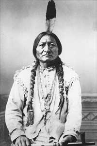
Sitting Bull was a Hunkpapa Lakota leader who led his people during years of resistance against United States government policies. He was killed by Indian agency police on the Standing Rock Indian Reservation during an attempt to arrest him, at a time when authorities feared that he would join the Ghost Dance movement.

<span class="mw-page-title-main">Treaty of Fort Laramie (1868)</span> US-Sioux treaty ending Red Clouds War

The Treaty of Fort Laramie is an agreement between the United States and the Oglala, Miniconjou, and Brulé bands of Lakota people, Yanktonai Dakota, and Arapaho Nation, following the failure of the first Fort Laramie treaty, signed in 1851.

<span class="mw-page-title-main">Arikara</span> Ethnic group

Arikara, also known as Sahnish, Arikaree, Ree, or Hundi, are a tribe of Native Americans in North Dakota. Today, they are enrolled with the Mandan and the Hidatsa as the federally recognized tribe known as the Mandan, Hidatsa, and Arikara Nation.

<span class="mw-page-title-main">Sioux Wars</span> Conflicts between the United States and indigenous Sioux tribes from 1854 to 1891

The Sioux Wars were a series of conflicts between the United States and various subgroups of the Sioux people which occurred in the later half of the 19th century. The earliest conflict came in 1854 when a fight broke out at Fort Laramie in Wyoming, when Sioux warriors killed 31 American soldiers in the Grattan Massacre, and the final came in 1890 during the Ghost Dance War.

<span class="mw-page-title-main">Hunkpapa</span> Traditional tribal grouping within the Lakota people

The Hunkpapa are a Native American group, one of the seven council fires of the Lakota tribe. The name Húŋkpapȟa is a Lakota word, meaning "Head of the Circle". By tradition, the Húŋkpapȟa set up their lodges at the entryway to the circle of the Great Council when the Sioux met in convocation. They speak Lakȟóta, one of the three dialects of the Sioux language.

<span class="mw-page-title-main">Great Sioux Reservation</span> Former Indian reservation in the United States

The Great Sioux Reservation initially set aside land west of the Missouri River in South Dakota and Nebraska for the use of the Sioux, who had dominated this territory. The reservation was established in the Fort Laramie Treaty of 1868. It included all of present-day western South Dakota and modern Boyd County, Nebraska. This area was established by the United States as a reservation for the Teton Sioux, also known as the Lakota: the seven western bands of the "Seven Council Fires".

Wooden Leg was a Northern Cheyenne warrior who fought against Custer at the Battle of the Little Big Horn.

<span class="mw-page-title-main">Dakota people</span> Native American people in the mid northern U.S. and mid southern Canada

The Dakota are a Native American tribe and First Nations band government in North America. They compose two of the three main subcultures of the Sioux people, and are typically divided into the Eastern Dakota and the Western Dakota.

<span class="mw-page-title-main">Native American tribes in Nebraska</span>

Native American tribes in the U.S. state of Nebraska have been Plains Indians, descendants of succeeding cultures of indigenous peoples who have occupied the area for thousands of years. More than 15 historic tribes have been identified as having lived in, hunted in, or otherwise occupied territory within the current state boundaries.

<span class="mw-page-title-main">Black Hills</span> Mountain range in South Dakota and Wyoming

The Black Hills is an isolated mountain range rising from the Great Plains of North America in western South Dakota and extending into Wyoming, United States. Black Elk Peak, which rises to 7,244 feet (2,208 m), is the range's highest summit. The Black Hills encompass the Black Hills National Forest. The name of the hills in Lakota is Pahá Sápa. The Black Hills are considered a holy site. The hills are so called because of their dark appearance from a distance, as they are covered in evergreen trees.

<span class="mw-page-title-main">Great Sioux War of 1876</span> Battles and negotiations between the US and the Lakota Sioux and Northern Cheyenne

The Great Sioux War of 1876, also known as the Black Hills War, was a series of battles and negotiations that occurred in 1876 and 1877 in an alliance of Lakota Sioux and Northern Cheyenne against the United States. The cause of the war was the desire of the US government to obtain ownership of the Black Hills. Gold had been discovered in the Black Hills, settlers began to encroach onto Native American lands, and the Sioux and the Cheyenne refused to cede ownership. Traditionally, American military and historians place the Lakota at the center of the story, especially because of their numbers, but some Native Americans believe the Cheyenne were the primary target of the American campaign.

<span class="mw-page-title-main">Seizure of the Black Hills</span> Land dispute between Native Americans and the US government

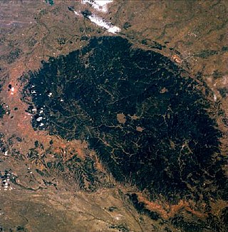
The United States government illegally seized the Black Hills – a mountain range in the US states of South Dakota and Wyoming – from the Sioux Nation in 1876. The land was pledged to the Sioux Nation in the Treaty of Fort Laramie, but a few years later the United States illegally seized the land and nullified the treaty with the Indian Appropriations Bill of 1876, without the tribe's consent. That bill "denied the Sioux all further appropriation and treaty-guaranteed annuities" until they gave up the Black Hills. A Supreme Court case was ruled in favor of the Sioux in 1980. As of 2011, the court's award was worth over $1 billion, but the Sioux have outstanding issues with the ruling and have not collected the funds.

<span class="mw-page-title-main">White Swan</span> Native American who served in the U.S. Army

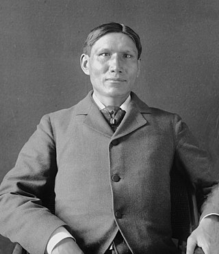
White Swan (c.1850—1904), or Mee-nah-tsee-us in the Crow language, was one of six Crow Scouts for George Armstrong Custer's 7th Cavalry Regiment during the 1876 campaign against the Sioux and Northern Cheyenne. At the Battle of the Little Bighorn in the Crow Indian Reservation, White Swan went with Major Reno's detachment, and fought alongside the soldiers at the south end of the village. Of the six Crow scouts at the Battle of the Little Bighorn, White Swan stands out because he aggressively sought combat with multiple Sioux and Cheyenne warriors, and he was the only Crow Scout to be wounded in action, suffering severe wounds to his hand/wrist and leg/foot. After being disabled by his wounds, he was taken to Reno's hill entrenchments by Half Yellow Face, the pipe-bearer (leader) of the Crow scouts, which no doubt saved his life.

This timeline of South Dakota is a list of events in the history of South Dakota by year.

<span class="mw-page-title-main">Early Indian treaty territories in North Dakota</span>

Native Americans from various tribes lived in North Dakota before the arrival of settlers. With time, a number of treaties and agreements were signed between the Indians and the newcomers. Many of the treaties defined the domain of a specific group of Indians. The three maps below show the treaty territories of different Indians living in North Dakota and how the territories changed and diminished over time in the 19th century.

<span class="mw-page-title-main">Arikara scouts</span> Military unit

Arikara scouts were enlisted men from the Arikara Nation serving in the U.S. Army at different frontier posts in present-day North Dakota from 1868 to 1881. The enlistment period was six months with re-enlistment possible. Each scout received a uniform, firearm and drew rations. Scout duties ranged from carrying mail between commands to tracking down traditional enemies perceived as hostile by the Army in far ranging military campaigns. Detailed to secure the horses in located enemy camps, the scouts were often the first to engage in battle. The Arikara took part when the Army protected survey crews in the Yellowstone area in the early 1870s. They participated in the Great Sioux War of 1876 and developed into Colonel George Armstrong Custer's "… most loyal and permanent scouts …".

References

  1. "QuickFacts: North Dakota; South Dakota". Census.gov. United States Census Bureau. Retrieved March 31, 2022.
  2. "Serengeti in the Dakotas", Scientific American. May 2007. Retrieved April 20, 2008.
  3. "Prairie Basin Wetlands of the Dakotas: A Community Profile. USGS Northern Prairie Wildlife Research Center. Retrieved April 20, 2008.
  4. "Wild Horses in Montana and the Dakotas", Retrieved April 20, 2008.
  5. "Time Passages, Genealogy of the Dakotas". Retrieved April 20, 2008.
  6. "Dakotas rank high on congressional pork list" [ permanent dead link ], ArgusLeader.com. April 2, 2008. Retrieved April 20, 2008.
  7. "Black Gold in the Dakotas", Dakota Voice. April 6, 2008. Retrieved April 20, 2008.
  8. Wieland, K. (2007) The Dakota Diet: Health Secrets from the Great Plains. Basic Health Publications.
  9. "Definition of DAKOTA". www.merriam-webster.com. Retrieved October 3, 2021.
  10. "Sioux | Tribes, Meaning, Languages, Religion, & Facts". Encyclopedia Britannica. Retrieved October 3, 2021.
  11. 1 2 Cutlip, Kimbra (November 7, 2018). "In 1868, Two Nations Made a Treaty, the U.S. Broke It and Plains Indian Tribes are Still Seeking Justice". Smithsonian Magazine.
  12. "New perspectives on the West: The Dakotas", PBS. Retrieved April 20, 2008.

Further reading

46°N100°W / 46°N 100°W / 46; -100