
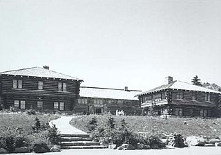
The Lake McDonald Lodge Historic District is a historic district in Glacier National Park in the U.S. state of Montana. It comprises the Lake McDonald Lodge and surrounding structures on the shores of Lake McDonald. It is centered on the main lodge, which was designated a National Historic Landmark in 1987, as well as surrounding guest cabins, dormitory buildings, employee residences, utility buildings, and retail structures. The district includes several privately owned inholding structures that are contributing structures, as well as a number of non-contributing buildings.

The Norris Geyser Basin Museum, also known as Norris Museum, is one of a series of "trailside museums" in Yellowstone National Park designed by architect Herbert Maier in a style that has become known as National Park Service Rustic. It is listed on the National Register of Historic Places, and is one of three parts of a National Historic Landmark, the Norris, Madison, and Fishing Bridge Museums, which were funded by Laura Spelman Rockefeller's grant of $118,000. Built 1929 - 1930, the Norris Museum is sited on a hill between the Porcelain Basin and the Back Basin of Norris Geyser Basin. Its central breezeway frames a view of the Porcelain Basin for arriving visitors.

Beaver Meadows Visitor Center, also known as Rocky Mountain National Park Administration Building, is the park headquarters and principal visitors center of Rocky Mountain National Park in central northern Colorado. Completed in 1967, it was designed by Taliesin Associated Architects, and was one of the most significant commissions for that firm in the years immediately following the death of founder Frank Lloyd Wright. It was also one of the last major projects completed under the Park Service Mission 66 project. It was declared a National Historic Landmark in 2001.

The Propulsion and Structural Test Facility, also known as Building 4572 and the Static Test Stand, is a rocket testing facility of the George C. Marshall Space Flight Center in Huntsville, Alabama. Built in 1957, it was the site where the first single-stage rockets with multiple engines were tested. It was declared a National Historic Landmark in 1985 for its role in the development of the United States space program.

The New Harmony Historic District is a National Historic Landmark District in New Harmony, Indiana. It received its landmark designation in 1965, and was placed on the National Register of Historic Places in 1966, with a boundary increase in 2000. The district includes properties within the Historic New Harmony State Historic Site. Twelve buildings from the early 19th century and twenty from the mid-19th century are within the district. The original boundary was Main Street between Granary and Church Streets and was later increased to include the area bounded by North and Steam Mill Streets and between Third and Arthur Streets.
The Yakima Park Stockade Group, also known as North and South Blockhouses, Museum, and Stockade at Sunrise, is a building complex consisting of four log buildings at the Sunrise Visitors Center area in the northeast part of Mount Rainier National Park. The complex is architecturally significant as a particularly fine example of rustic frontier log architecture. The first of the blockhouses and the stockade were built in 1930, while the second blockhouse followed in 1943. It was declared a National Historic Landmark in 1987. It is in turn part of the Mount Rainier National Historic Landmark District, which encompasses the entire park and which recognizes the park's inventory of Park Service-designed rustic architecture.

Beallsville Historic District is a 40-acre (16 ha) district in Beallsville, Pennsylvania. It is designated as a historic district by the Washington County History & Landmarks Foundation.

Mirador is a historic home located near Greenwood, Albemarle County, Virginia. It was built in 1842 for James M. Bowen (1793–1880), and is a two-story, brick structure on a raised basement in the Federal style. It has a deck-on-hip roof capped by a Chinese Chippendale railing. The front facade features a portico with paired Tuscan order columns. The house was renovated in the 1920s by noted New York architect William Adams Delano (1874–1960), who transformed the house into a Georgian Revival mansion.

The Bergland Administrative Site, also known as the Bergland Ranger Station, is a government administrative complex consisting of six buildings located along M-28 in Bergland, Michigan. It was listed on the National Register of Historic Places in 2005, and currently houses the Bergland Cultural & Heritage Center and The Bergland/Matchwood Historical Society Museum.
Rock Hill Farm, also known as the Davis-Stauffer Farm Complex, is a historic home and farm and national historic district located at Montgomery Township in Franklin County, Pennsylvania. The district includes 12 contributing buildings, 2 contributing sites, and 3 contributing structures. They are associated with three areas: the Davis-Chamber farmstead, Eliab Negley House, and Joseph Negley farmstead. Contributing components of the Davis-Chamber farmstead include the log and frame main house, 18th century log smokehouse, limestone milk house, frame wash house, frame outhouse, frame wagon shed, and a frame barn with concrete sile. The property also includes a stone wall, and the archaeological remains of earlier buildings including a limestone mill dismantled about 1930. The Eliab Negley House is a log dwelling built between 1810 and 1823. The Joseph Negley farmstead includes a Greek Revival-style dwelling built between 1836 and 1850, with later modifications about 1900. Also on the property are a contributing 19th century smokehouse, a frame wagon shed, and a large shed.
Danville Historic District is a national historic district located in Danville, Montour County, Pennsylvania. It encompasses 291 contributing buildings, 3 contributing sites, and 1 contributing object in the central business district and surrounding residential areas of Danville. The buildings mostly date from the 1840s to the early 20th century. The district incorporates the previously listed and predominantly residential Danville West Market Street Historic District. Residential buildings are mostly of brick and frame construction, with some log and stone dwellings, and in a variety of architectural styles including Italianate, Federal, Queen Anne and Second Empire. It includes the separately listed General William Montgomery House and Thomas Beaver Free Library and Danville YMCA. Other notable non-residential buildings include the Montour County Courthouse (1871), Mahoning Presbyterian Church (1853), Pine Street Lutheran Church, Eli Trego Building, Heim Suspender Factory (1835), First Ward School, Bnai Zion Temple, and Jemima Donaldson's Cross Keys Tavern.
Brookside Farm and Mill is a historic grist mill and farm complex located at Independence, Grayson County, Virginia. The Brookside Mill was built in 1876, and is a three-story, three bay by three bay, heavy timber frame building measuring 30 feet by 35 feet. The principal dwelling was built in 1877, and is a two-story, three bay, frame building with a central passage plan. Other contributing buildings and structures include a brick spring house, brick smokehouse, log corn crib, frame hen house, miller's cabin, the miller's cottage or Graham House, a frame service station / garage (1918), and concrete dam (1914) and earthen mill race.
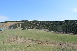
Spring Valley Rural Historic District is a national historic district located near Fries, Grayson County, Virginia. The district encompasses 184 contributing buildings, 3 contributing sites, and 1 contributing object in the wooded and agricultural northeastern corner of Grayson County. It includes mostly frame or log structures, with a few brick buildings, and several well-preserved examples of early-19th century log dwellings still in use. Notable buildings include the Knob Fork Primitive Baptist Church, William Bourne House "Walnut Hill", Austin King House, Tomlinson House, O'Donnell Place, Ephraim Boyer House, John Fielder Farmhouse, Ebenezer Methodist Church and Cemetery, Spring Valley Academy, Glenn Cornett House (1904), and Phipps Bourne Farmstead (1909). Located in the district is the separately listed Stephen G. Bourne House.

Solitude is a historic home located on the campus of Virginia Polytechnic Institute at Blacksburg, Montgomery County, Virginia. The earliest section was built about 1802, and expanded first in circa 1834 and then in the 1850s by Col. Robert Preston, who received the land surrounding Solitude from his father, Virginia Governor James Patton Preston. Dating back over 200 years, Solitude is the oldest building on the Virginia Tech Blacksburg campus.
East Main Street Historic District is a national historic district located at Christiansburg, Montgomery County, Virginia. The district encompasses 45 contributing buildings and 1 contributing site in the town of Christiansburg. It includes principally single family brick and frame dwellings dated to the late-19th and early-20th centuries. They are reflective of a variety of popular architectural styles, in including Colonial Revival and Queen Anne. It also includes two early 19th century log houses, St. Thomas Episcopal Church, the much altered Christiansburg Municipal Building, the early 20th century former Christiansburg High School buildings, and an elementary school.
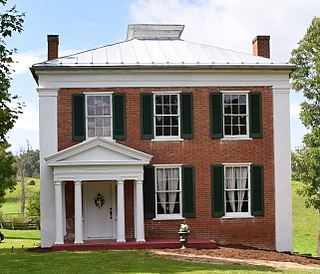
Church Hill, also known as Timber Ridge Plantation, is a historic plantation house located near Lexington, Rockbridge County, Virginia. It was built circa 1848, and is a two-story, three bay, rectangular brick Greek Revival style dwelling. It has a one-story, rear kitchen ell. The house features stuccoed Doric order pilasters at the corners and midpoints of the long sides. Timber Ridge Plantation was the birthplace of Sam Houston (1793-1863). On the property is a non-contributing log building which tradition claims was constructed from logs salvaged from the Sam Houston birthplace cabin. The cabin is believed to have been located at the site of the kitchen ell.
George Oscar Thompson House, also known as the Sam Ward Bishop House, was a historic home located near Tazewell, Tazewell County, Virginia. It was built in 1886–1887, and was a two-story, three bay, "T"-shaped frame dwelling. It had a foundation of rubble limestone. The front facade featured a one-story porch on the center bay supported by chamfered posts embellished with sawn brackets. Also on the property were a contributing limestone spring house, a one-room log structure, and a 1+1⁄2-story frame structure. Tradition suggests the latter buildings were the first and second houses built by the Thompson family.

The Forestville Historic District is a national historic district located at Forestville, Shenandoah County, Virginia. The district encompasses 84 contributing buildings, 4 contributing sites, and 1 contributing structure in the 19th century mill village of Forestville. The vernacular buildings represent a variety of popular architectural styles including Greek Revival, Queen Anne, and Italianate. The buildings date from the late-18th to mid-20th centuries and primarily include log and wood-frame single dwellings, with domestic and agricultural dependencies, that dominate the district are substantiated by a gristmill, two commercial buildings. Also in the district are a church, a cemetery, a post office, two doctors' offices, and a school.


