Sierra de San Borja

Last updated
Sierra de San Borja
Geography
Location Baja California, Mexico
Range coordinates 28°22′N113°21′W / 28.37°N 113.35°W / 28.37; -113.35 Coordinates: 28°22′N113°21′W / 28.37°N 113.35°W / 28.37; -113.35

The Sierra de San Borja, also known as Sierra La Libertad is a mountain range on the Baja California Peninsula of Mexico. It is one of the Peninsular Ranges which form the backbone of Baja California. The Sierra de San Borja is located between 28° North latitude (the border of the states of Baja California and Baja California Sur) and 29° North latitude (Highway 12). The highest point of the Sierra is Cerro La Sandia, 1,775 metres (5,823 ft) in elevation located at 28°24′25″N113°26′18″W / 28.40694°N 113.43833°W / 28.40694; -113.43833 . [1]

Baja California Peninsula peninsula of North America on the Pacific Coast of Mexico

The Baja California Peninsula is a peninsula in Northwestern Mexico. It separates the Pacific Ocean from the Gulf of California. The peninsula extends 1,247 km from Mexicali, Baja California in the north to Cabo San Lucas, Baja California Sur in the south. It ranges from 40 km at its narrowest to 320 km at its widest point and has approximately 3,000 km of coastline and approximately 65 islands. The total area of the Baja California Peninsula is 143,390 km2 (55,360 sq mi).

Mexico country in the southern portion of North America

Mexico, officially the United Mexican States, is a country in the southern portion of North America. It is bordered to the north by the United States; to the south and west by the Pacific Ocean; to the southeast by Guatemala, Belize, and the Caribbean Sea; and to the east by the Gulf of Mexico. Covering almost 2,000,000 square kilometres (770,000 sq mi), the nation is the fifth largest country in the Americas by total area and the 13th largest independent state in the world. With an estimated population of over 120 million people, the country is the eleventh most populous state and the most populous Spanish-speaking state in the world, while being the second most populous nation in Latin America after Brazil. Mexico is a federation comprising 31 states and Mexico City, a special federal entity that is also the capital city and its most populous city. Other metropolises in the state include Guadalajara, Monterrey, Puebla, Toluca, Tijuana and León.

Peninsular Ranges

The Peninsular Ranges are a group of mountain ranges that stretch 1,500 km (930 mi) from Southern California to the southern tip of the Baja California Peninsula; they are part of the North American Coast Ranges, which run along the Pacific Coast from Alaska to Mexico. Elevations range from 500 to 10,834 feet.

Contents

The Sierra de San Borja is nearly uninhabited. Desert vegetation prevails with only a few water sources. Tourists visit the San Francisco Borja Mission (founded 1762) and the extensive prehistoric rock art scattered throughout the mountains.

Misión San Francisco Borja

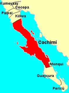
San Borja was a Spanish mission established in 1762 by the Jesuit Wenceslaus Linck at the Cochimí settlement of Adac, west of Bahía de los Ángeles.

History

The inhabitants of the Sierra de San Borja when first visited by Jesuit Catholic missionaries early in the 18th century were Cochimí Indians, nomadic hunter-gatherers. In 1752. the Jesuits established the Santa Gertrudis Mission at the southern end of the Sierra de San Borja and in 1762 the San Francisco de Borja Adac Mission, Adac being the name of the Cochimí rancheria settlement at the site. At their most active in the 1760s, each of the missions attracted about 1,700 Cochimí as temporary residents, but those numbers were unsustainable and introduced European diseases rapidly caused a decline in the Indian population. [2] Both missions were closed in the early 19th century, although a few people still live at the site of each mission and irrigate several acres of farmland.

Catholic Church Christian church led by the Bishop of Rome

The Catholic Church, also known as the Roman Catholic Church, is the largest Christian church, with approximately 1.3 billion baptised Catholics worldwide as of 2016. As the world's "oldest continuously functioning international institution", it has played a prominent role in the history and development of Western civilisation. The church is headed by the Bishop of Rome, known as the Pope. Its central administration, the Holy See, is in the Vatican City, an enclave within the city of Rome in Italy.

Cochimí aboriginal inhabitants of the central part of the Baja California peninsula, from El Rosario in the north to San Javier in the south

The Cochimí were the aboriginal inhabitants of the central part of the Baja California peninsula, from El Rosario in the north to San Javier in the south.

Misión Santa Gertrudis

Mission Santa Gertrudis, called Dolores del Norte by some historians, was founded by the Jesuit missionary Jorge Retz in 1751 among the Cochimí Indians of the Baja California Peninsula, about 80 kilometers north of San Ignacio. The mission is located in the modern-day Mexican state of Baja California.

Climate

Most or all of the Sierra de San Borja has a desert climate: Bwh in the Köppen climate classification system. The mountain range does not capture enough precipitation to support the oak-pine forests of the higher and more humid mountain ranges in northern and southern Baja California The climatic averages for San Ignacio (near the San Borja mission and not to be confused with San Ignacio, Baja California Sur) are typical of the region at the lower elevations: hot summer temperatures (but moderated by the nearby Pacific Ocean and Gulf of California) and unpredictable and irregular precipitation, mostly in the winter months,

Köppen climate classification widely used climate classification system

The Köppen climate classification is one of the most widely used climate classification systems. It was first published by the Russian climatologist Wladimir Köppen (1846–1940) in 1884, with several later modifications by Köppen, notably in 1918 and 1936. Later, the climatologist Rudolf Geiger introduced some changes to the classification system, which is thus sometimes called the Köppen–Geiger climate classification system.

San Ignacio, Baja California Sur Place in Baja California Sur, Mexico

San Ignacio is a palm oasis town in Mulegé Municipality of northern Baja California Sur state in Mexico.

Pacific Ocean Ocean between Asia and Australia in the west, the Americas in the east and Antarctica or the Southern Ocean in the south.

The Pacific Ocean is the largest and deepest of Earth's oceanic divisions. It extends from the Arctic Ocean in the north to the Southern Ocean in the south and is bounded by Asia and Australia in the west and the Americas in the east.

Climate data for San Ignacio, Baja California, 28° 44′ N 113° 45′ W. Elevation: 445 m (1,460 ft)
MonthJanFebMarAprMayJunJulAugSepOctNovDecYear
Average high °C (°F)21.8
(71.2)
23.1
(73.6)
23.8
(74.8)
25.8
(78.4)
27.6
(81.7)
31.3
(88.3)
34.3
(93.7)
34.4
(93.9)
33.2
(91.8)
29.2
(84.6)
25.8
(78.4)
22.6
(72.7)
27.7
(81.9)
Daily mean °C (°F)15.0
(59)
15.8
(60.4)
16.3
(61.3)
17.6
(63.7)
19.1
(66.4)
22.1
(71.8)
25.6
(78.1)
26.3
(79.3)
24.8
(76.6)
21.4
(70.5)
18.6
(65.5)
15.8
(60.4)
19.9
(67.8)
Average low °C (°F)8.2
(46.8)
8.6
(47.5)
8.8
(47.8)
9.3
(48.7)
10.5
(50.9)
12.9
(55.2)
16.9
(62.4)
18.2
(64.8)
17.5
(63.5)
13.7
(56.7)
11.4
(52.5)
9.0
(48.2)
12.1
(53.8)
Average precipitation mm (inches)17
(0.67)
15
(0.59)
11
(0.43)
4
(0.16)
1
(0.04)
0
(0)
4
(0.16)
6
(0.24)
15
(0.59)
8
(0.31)
7
(0.28)
25
(0.98)
113
(4.45)
Source: Weatherbase: San Ignacio, Baja California [3]

Rock paintings

An example of Great Mural rock art. Antropologia - Museo Nacional de Antropologia ovedc wikimania 070.jpg
An example of Great Mural rock art.

The Sierra de San Borja is the northernmost outpost of the "Great Mural" rock art of the central Baja California mountains. In explorations in the 1970s, author Harry W. Crosby found six major sites of Great Mural rock art southeast of the San Borja mission. [4] Several others have since been discovered. Great mural rock Art consists of prehistoric paintings of humans and other animals, often larger than life-size, on the walls and ceilings of natural rock shelters.

Harry W. Crosby is an American historian and photographer. His parents moved to La Jolla in 1935. He graduated from La Jolla High School in 1944, and studied math and science at Occidental College in Los Angeles, completing a double major in pre-med and psychology. After twelve years as a teacher of secondary-level science, mostly chemistry, he took up photography, and in 1967, was hired as a photographer to illustrate the book The Call to California for the Commission of the Californias, commemorating California's bicentennial. Following the route of the Portolá expedition of 1769 to make photos to illustrate a text derived from diaries of the trekkers, Crosby rode 600 miles on muleback on remote trails. Since then, he has continued to do primary research and to write extensively on the history and cave paintings of Baja California and the early history of Alta California.

The number of Great Mural sites in the San Borja mountains is fewer than further south in the Sierra de San Francisco where the rock paintings have been declared a World Heritage Site by UNESCO. The area near the San Borja Mission is a dividing line between the Great Mural rock art to the south and the more abstract style of rock painting found to the north. [5] The paintings of the Great Mural rock art of the Sierra de San Borja are smaller than more southerly works, less diverse in their subject matter, and are always colored in shades of red. Given their similarity to each other, Crosby speculated that the San Borja rock paintings were created by a single ethnic group and within a relatively short period of time. [6]

Rock Paintings of Sierra de San Francisco

The Rock Paintings of Sierra de San Francisco are prehistoric rock art pictographs found in the Sierra de San Francisco mountain range in Mulegé Municipality of the northern region of Baja California Sur state, in Mexico.

UNESCO Specialised agency of the United Nations

The United Nations Educational, Scientific and Cultural Organization is a specialized agency of the United Nations (UN) based in Paris. Its declared purpose is to contribute to peace and security by promoting international collaboration through educational, scientific, and cultural reforms in order to increase universal respect for justice, the rule of law, and human rights along with fundamental freedom proclaimed in the United Nations Charter. It is the successor of the League of Nations' International Committee on Intellectual Cooperation.

Jesuit missionaries became aware of some of the Great Murals in the eighteenth century but the local Cochimí Indians disclaimed any knowledge of their origin. The dates that the Great Murals were painted is in dispute, with post-400 BCE being most widely accepted. but radiocarbon dating at the site of San Borjitas (south of the Sierra de San Borja) suggest that the murals at that site may be as old as 5500 BCE. [7]

Conservation

The Sierra de San Borja and neighboring mountain ranges are recognized as a Priority Region for the Conservation of Biodiversity by the government of Mexico. The Region, called Sierras la Libertad-La Assemblea, has an area of 5,192 square kilometres (2,005 sq mi). [8]

Related Research Articles

Baja California Sur State of Mexico

Baja California Sur, officially the Estado Libre y Soberano de Baja California Sur, is the second-smallest Mexican state by population and the 31st admitted state of the 31 states which, with Mexico City, make up the 32 Federal Entities of Mexico.

Bahía de los Ángeles Place in Baja California, Mexico

Bahía de los Ángeles is a coastal bay on the Gulf of California, located along the eastern shore of the Baja California Peninsula in the state of Baja California, Mexico. The town of the same name is located at the east end of Federal Highway 12 about 42 miles (68 km) from the Parador Punta Prieta junction on Federal Highway 1. The area is part of the Ensenada Municipality.

Misión San Francisco Javier de Viggé-Biaundó

Misión San Francisco Javier de Viggé-Biaundó was a Spanish mission on the Baja California peninsula in colonial Mexico, the Viceroyalty of New Spain. The site is in present-day Loreto Municipality of Baja California Sur state. The mission was located at 25°51′38″N111°32′37″W. San Francisco Javier mission was founded by Jesuits of the Roman Catholic church in 1699 and closed in 1817. The missionary's objective was to convert the local Cochimí Native Americans (Indians) to Christianity. A mission church survives and is in use.

Sierra de Guadalupe cave paintings

The Sierra de Guadalupe cave paintings are a series of prehistoric rock art pictographs near Rancho La Trinidad, Mulegé in Baja California Sur, Mexico. The Sierra de Guadalupe, mountains west of Mulegé, contains the largest number of known prehistoric rock art sites in Baja California.

Sigismundo Taraval (1700–1763) was a pioneering Jesuit missionary in Baja California who wrote important historical accounts of the peninsula.

Monqui

The Monqui were indigenous peoples of Mexico, who lived in the vicinity of Loreto, Baja California Sur, Mexico, at the time of Spanish contact. Monqui territory included about 65 kilometres (40 mi) of coast along the Gulf of California and extended a few kilometers inland to where the Cochimi people lived.

Wenceslaus Linck was the last of the outstanding Jesuit missionary-explorers in Baja California.

Francisco María Piccolo, S.J., (1654–1729) was one of the first Jesuit missionaries in Baja California Sur, New Spain, now Mexico. His letters and reports are important sources for the ethnography and early history of the peninsula.

Juan de Ugarte Central American Jesuit priest and missionary

Juan de Ugarte, S.J., (1662–1730) was a Jesuit missionary and explorer in Baja California Sur, New Spain, and the successor to Juan María de Salvatierra as head of the peninsula's missions.

The Comondú Complex is an archaeological pattern dating from the late prehistoric period in northern Baja California Sur and southern Baja California. It is associated with the historic Cochimí people of the peninsula.

Great Mural Rock Art

Great Mural Rock Art consists of prehistoric paintings of humans and other animals, often larger than life-size, on the walls and ceilings of natural rock shelters in the mountains of northern Baja California Sur and southern Baja California, Mexico. This group of monuments comprises the site Rock Paintings of Sierra de San Francisco, which is included on the UNESCO World Heritage List.

The Sierra de San Francisco is a mountain range in Mulegé Municipality of the northern region of Baja California Sur state, in northwestern Mexico.

José Mariano Rotea (1732—1799) was a Jesuit missionary on the Baja California peninsula who played a key role in the rediscovery of the peninsula's prehistoric Great Murals rock art.

References

  1. Google Earth; "Cerro La Sandia, http://www.peakbagger.com/peak.aspx?pid=1533, accessed 4 Apr 2016
  2. Kier, David, "The Spanish Missions on the California Peninsula: #15 Santa Gertrudis (1752-1822) and #16 San Francisco de Borja Adac (1662-1818), http://www.discoverbaja.com/2014/08/16/the-spanish-missions-on-the-california-peninsula-16-san-francisco-de-borja-adac-1762-1818, http://www.discoverbaja.com/2014/08/15/the-spanish-missions-on-the-california-peninsula-15-santa-gertrudis-1752-1822/, accessed 18 Mar 2016
  3. "Travel Weather Averages". Weatherbase. Retrieved February 24, 2013.
  4. Crosby, Harry (1995) "Red-on-Granite Rock Painting in the Sierra de San Borja", Estudios Fronterizos, No. 35-36, pp. 83-91
  5. Harman, Jon (2014), "A Tale of Two Cañadas: The Most Northerly Great Mural Site Yet Discovered', SCA Proceedings, Vol. 28, p. 206
  6. Crosby, pp. 87-90
  7. Hyland, Justin R. (2006), "The Central Sierras", in The Prehistory of Baja California, edited by Don Laylander and Jerry D. Moore, Gainesville: University of Florida Press, p. 127
  8. "Sierras La Libertad-La Assamblea" http://www.conabio.gob.mx/conocimiento/regionalizacion/doctos/rtp_006.pdf, accessed 20 Mar 2016