Related Research Articles
Marys River is a 40-mile (64 km) tributary of the Willamette River in the U.S. state of Oregon. From its source at the confluence of its east and west forks near Summit, it flows generally southeast from the Central Oregon Coast Range to Corvallis.

The Youngs River is a tributary of the Columbia River, approximately 27 miles (43 km) long, in northwest Oregon in the United States. It drains part of the Northern Oregon Coast Range in the extreme northwest corner of state, entering the Columbia via Youngs Bay just approximately 10 miles (16 km) from its mouth.
The Wallooskee River is a tributary of the Youngs River, about 10 miles (16 km) long, in northwest Oregon in the United States. It drains a small area of the foothills of the Coast Range near the mouth of the Columbia River. The Youngs River is a tributary of the Columbia River.
The Clatskanie River is a tributary of the Columbia River, approximately 25 miles (40 km) long, in northwestern Oregon in the United States. It drains a timber-producing area in the foothills of the Northern Oregon Coast Range north-northwest of Portland.

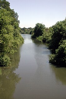
The John Day River is a tributary of the Columbia River, approximately 6 miles (10 km) long, in northwestern Oregon in the United States. The river rises in the Northern Oregon Coast Range in Clatsop County at 46.138889°N 123.704722°W.
Ash is an unincorporated community in Douglas County, Oregon, United States, south of Loon Lake in the Southern Oregon Coast Range. The community is also referred to as Ash Valley.

Kelley Point Park is a city park in north Portland in the U.S. state of Oregon. Bounded by the Columbia Slough on the south, the Willamette River on the west, and the Columbia River on the north, the park forms the tip of the peninsula at the confluence of the rivers. Marine Terminal 6 of the Port of Portland lies immediately east of the park along the Columbia, while Terminal 5 is along the Willamette slightly south of the Columbia Slough. The park is at 45.6498384°N 122.7637106°W and rises to an elevation of 39 feet (12 m) above sea level. Sauvie Island is west of the park across the Willamette River. Hayden Island is slightly upstream of the park on the Columbia River opposite Marine Terminal 6.
Tenmile is an unincorporated community in Douglas County, Oregon, United States. It is located on Oregon Route 42 southwest of Roseburg.

Horton is an unincorporated community in Lane County, Oregon, United States. It is about three miles northeast of Blachly, in the Lake Creek valley of the Central Oregon Coast Range.

Olney is an unincorporated community and former company town in Clatsop County, Oregon, United States, on Oregon Route 202 approximately eight miles south of Astoria. Olney is located at 46.100109°N 123.757637°W. Its post office is assigned ZIP code 97325.
Wyeth is an unincorporated locale in Hood River County, Oregon, United States. It is the site of a campground area in the Columbia River Gorge National Scenic Area off Interstate 84 (I-84).

Quincy is an unincorporated community in Columbia County, Oregon, United States. It is located about 4.5 miles northeast of Clatskanie and 3.5 miles southwest of Mayger in a drained and diked area of the Columbia River lowlands.
Tiernan is an unincorporated community in Lane County, Oregon, United States. It is about five miles west of Mapleton on Oregon Route 126 near the Siuslaw River and within the Siuslaw National Forest.
Walker is an unincorporated community in Lane County, Oregon, United States. It is located about 4 miles (6 km) north of Cottage Grove on Oregon Route 99, near the Coast Fork Willamette River.
Burnt Woods is an unincorporated community in Lincoln County, Oregon, United States. It is located about 16 miles (26 km) west of Philomath on U.S. Route 20 in the Central Oregon Coast Range near the Tumtum River.
Hamlet is an unincorporated community in Clatsop County, Oregon, United States. It is located approximately six miles southeast of Necanicum, in the Northern Oregon Coast Range near the confluence of the North Fork Nehalem River and the Little North Fork Nehalem River. It is surrounded by units of the Clatsop State Forest.
Holland is an unincorporated community in Josephine County, Oregon, United States. It is about eight miles southeast of Cave Junction, in the Illinois Valley south of Oregon Route 46.
Pleasant Valley is an unincorporated community in Tillamook County, Oregon, United States. It is located about seven miles south of Tillamook, on U.S. Route 101.
Peel is an unincorporated community in Douglas County, Oregon, United States. It is located about six miles southeast of Glide near the Little River.
Fort Hill is an unincorporated community in Polk and Yamhill counties in Oregon, United States. It is located about a mile east of Spirit Mountain Casino on Oregon Route 22 near the South Yamhill River. For statistical purposes, the United States Census Bureau has defined Fort Hill as a census-designated place (CDP). The census definition of the area may not precisely correspond to local understanding of the area with the same name. The hill of the same name, located just east of Valley Junction, was the site of a blockhouse built by settlers in 1855–1856. The blockhouse became part of Fort Yamhill, and was later moved to Grand Ronde Agency and is now located in Dayton.
References
- ↑ "Woodson". Geographic Names Information System . United States Geological Survey. November 28, 1980. Retrieved November 28, 2010.
- 1 2 McArthur, Lewis A.; McArthur, Lewis L. (2003) [1928]. Oregon Geographic Names (7th ed.). Portland, Oregon: Oregon Historical Society Press. p. 1057. ISBN 978-0875952772.
Municipalities and communities of Columbia County, Oregon, United States | ||
|---|---|---|
| Cities |  | |
| CDPs | ||
| Other unincorporated communities | ||
Coordinates: 46°06′52″N123°19′27″W / 46.114555°N 123.324291°W
| | This Columbia County, Oregon state location article is a stub. You can help Wikipedia by expanding it. |