Deer Island, Oregon | |
|---|---|
 Former Deer Island School | |
 Deer Island  Deer Island | |
| Coordinates: 45°55′59″N122°50′59″W / 45.93306°N 122.84972°W | |
| Country | United States |
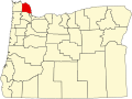
| State | Oregon |
| County | Columbia |
| Area | |
• Total | 0.49 sq mi (1.26 km2) |
| • Land | 0.49 sq mi (1.26 km2) |
| • Water | 0.00 sq mi (0.00 km2) |
| Elevation | 26 ft (8 m) |
| Population | |
• Total | 323 |
| • Density | 661.89/sq mi (255.52/km2) |
| Time zone | UTC-8 (Pacific (PST)) |
| • Summer (DST) | UTC-7 (PDT) |
| Area codes | 503 & 971 |
| GNIS feature ID | 2611727 [2] |
Deer Island is an unincorporated community and census-designated place in Columbia County, Oregon, United States. As of the 2010 census it had a population of 294. [4]
Contents
The community is located along U.S. Route 30 north-northwest of Columbia City. Deer Island has a post office with ZIP code 97054. [5]