Green Meadows, Oregon | |
|---|---|
 Green Meadows  Green Meadows | |
| Coordinates: 45°36′59″N118°48′10″W / 45.61639°N 118.80278°W | |
| Country | United States |
| State | Oregon |
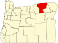
| County | Umatilla |
| Area | |
• Total | 1.23 sq mi (3.18 km2) |
| • Land | 1.23 sq mi (3.18 km2) |
| • Water | 0.00 sq mi (0.00 km2) |
| Elevation | 1,161 ft (354 m) |
| Population | |
• Total | 675 |
| • Density | 550.57/sq mi (212.59/km2) |
| Time zone | UTC-8 (Pacific (PST)) |
| • Summer (DST) | UTC-7 (PDT) |
| ZIP Code | 97801 (Pendleton) |
| Area code(s) | 541/458 |
| FIPS code | 41-31115 |
| GNIS feature ID | 2611733 [2] |
Green Meadows is an unincorporated community and census-designated place (CDP) in Umatilla County, Oregon, United States. It was first listed as a CDP following the 2010 census. [2]
The CDP is in central Umatilla County along U.S. Route 395, 5 miles (8 km) south of Pendleton, the county seat. It is on the east side of the valley of McKay Creek, a north-flowing tributary of the Umatilla River, which in turn is a west-flowing tributary of the Columbia.