Blakeley, Oregon | |
|---|---|
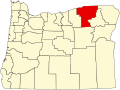
 Blakeley, Oregon Location within the state of Oregon | |
| Coordinates: 45°44′29″N118°36′15″W / 45.74139°N 118.60417°W | |
| Country | United States |
| State | Oregon |
| County | Umatilla |
| Elevation | 1,417 ft (432 m) |
| Time zone | UTC-8 (Pacific (PST)) |
| • Summer (DST) | UTC-7 (PDT) |
| Area codes | 458 and 541 |
| GNIS feature ID | 1136079 [1] |
| Coordinates and elevation from Geographic Names Information System | |
Blakeley is an unincorporated historic community [1] in Umatilla County, Oregon, United States between Pendleton and Milton-Freewater. It is just north of Oregon Route 11 on Wildhorse Creek. Blakeley was once a station on the Union Pacific Railroad. [2] The station was first named "Eastland" after Robert E. Eastland, who received a patent on land nearby in 1880. [2] The name was later changed to honor William M. Blakley (alternatively spelled "Blakeley" and "Blakely"), an Oregon state representative from 1902–1906, and a wheat grower in the area. [2] The elevation is 1417 ft (432 m) above sea level. [1]