


The Walk of Flags, or Walk of the Flags, is located in Willson Park, on the Oregon State Capitol grounds, in Salem, Oregon, United States. It features the flags of the U.S. states, displayed in the order in which they were admitted to the Union.
The Walk of Flags, or Walk of the Flags, is located in Willson Park, on the Oregon State Capitol grounds, in Salem, Oregon, United States. It features the flags of the U.S. states, displayed in the order in which they were admitted to the Union.
The "walk" was dedicated on June 14, 2005, and the nine flags of Oregon's federally recognized Native American tribes were added as a separate display in 2009. [1] [2] These tribes include: Burns Paiute Tribe, Confederated Tribes of Coos, Lower Umpqua and Siuslaw, Coquille Indian Tribe, Cow Creek Band of Umpqua Tribe of Indians, Confederated Tribes of the Grand Ronde Community, Klamath Tribes, Confederated Tribes of Siletz Indians, Confederated Tribes of the Umatilla Indian Reservation, and the Confederated Tribes of Warm Springs. [1]
The Oregon Legislative Assembly voted to remove the flag of Mississippi because of its Confederate emblem in 2016, [3] [4] [5] but it was returned after the state flag was changed in 2021. [1]
Coos people are an indigenous people of the Northwest Plateau, living in Oregon. They live on the southwest Oregon Pacific coast. Today, Coos people are enrolled in the following federally recognized tribes:
The Umpqua people are an umbrella group of several distinct tribal entities of Native Americans of the Umpqua Basin in present-day south central Oregon in the United States. The area south of Roseburg is now known as the Umpqua Valley.

The flag of Mississippi, also known as the Mississippi flag, consists of a white magnolia blossom surrounded by 21 stars and the words 'In God We Trust' written below, all put over a blue Canadian pale with two vertical gold borders on a red field. The topmost star is composed of a pattern of five diamonds, an Indigenous symbol; the other 20 stars are white, as Mississippi was the 20th state to join the Union. The flag was adopted on January 11, 2021.
The Siletz were the southernmost of several divisions of the Tillamook people speaking a distinct dialect; the other dialect-divisions were: Salmon River on the Salmon River, Nestucca on Little Nestucca River, Nestucca River and Nestucca Bay, Tillamook Bay on the Tillamook Bay and the mouths of the Kilchis, Wilson, Trask and Tillamook rivers, and Nehalem on Nehalem River. The name "Siletz" comes from the name of the Siletz River on which they live. The origin of the name is unknown

The Kalapuya are a Native American people, which had eight independent groups speaking three mutually intelligible dialects. The Kalapuya tribes' traditional homelands were the Willamette Valley of present-day western Oregon in the United States, an area bounded by the Cascade Range to the east, the Oregon Coast Range at the west, the Columbia River at the north, to the Calapooya Mountains of the Umpqua River at the south.
The Confederated Tribes of the Coos, Lower Umpqua and Siuslaw Indians of Oregon are a federally recognized Native American tribe of Hanis Coos, Miluk Coos, Lower Umpqua, and Siuslaw people in Oregon.

The Confederated Tribes of the Grand Ronde Community of Oregon (CTGR) consists of twenty-seven Native American tribes with long historical ties to present-day western Oregon between the western boundary of the Oregon Coast and the eastern boundary of the Cascade Range, and the northern boundary of southwestern Washington and the southern boundary of northern California. The community has an 11,288-acre (45.7 km2) Indian reservation, the Grand Ronde Indian Reservation, which was established in 1855 in Yamhill and Polk counties.
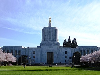
The Oregon State Capitol is the building housing the state legislature and the offices of the governor, secretary of state, and treasurer of the U.S. state of Oregon. It is located in the state capital, Salem. Constructed from 1936 to 1938 and expanded in 1977, the current building is the third to house the Oregon state government in Salem. The first two capitols in Salem were destroyed by fire, one in 1855 and the other in 1935.
The Confederated Tribes of Siletz Indians in the United States is a federally recognized confederation of more than 27 Native American tribes and bands who once inhabited an extensive homeland of more than 20 million acres from northern California to southwest Washington and between the summit of the Cascades and the Pacific Ocean. After the Rogue River Wars, these tribes were removed to the Coast Indian Reservation, now known as the Siletz Reservation. The tribes spoke at least 11 distinct languages, including Tillamook, Shasta, Lower Chinook, Kalapuya, Takelma, Alsea-Yaquina, Siuslaw/Lower Umpqua, Coos, the Plateau Penutian languages Molala and Klickitat, and several related Oregon Athabaskan languages.

The Grand Ronde Community is an Indian reservation located on several non-contiguous sections of land in southwestern Yamhill County and northwestern Polk County, Oregon, United States, about 18 miles (29 km) east of Lincoln City, near the community of Grand Ronde. In the mid-19th century, the United States government forced various tribes and bands from all parts of Western Oregon to be removed from their homes and placed on this reservation. It is governed by the Confederated Tribes of the Grand Ronde Community of Oregon. The reservation has a land area of 16.384 square miles (42.43 km2). In the 2000 census recorded a population of 55 persons. Most members of the tribe live elsewhere in order to find work.

Fort Umpqua was a trading post built by the Hudson's Bay Company in the company's Columbia District, in what is now the U.S. state of Oregon. It was first established in 1832 and moved and rebuilt in 1836.
The Oregon Superintendent of Indian Affairs was an official position of the U.S. state of Oregon, and previously of the Oregon Territory, that existed from 1848 to 1873.

Lorane is an unincorporated community in Lane County, Oregon, United States. It is located on Territorial Road about 20 miles (32 km) southwest of Eugene; it is 13 miles (21 km) northwest of Cottage Grove. The community is near the headwaters of the North Fork Siuslaw River in a valley in the foothills of the Central Oregon Coast Range. Local businesses include several wineries, including the King Estate Winery, Chateau Lorane Winery and Iris Hill Winery, and two general stores.

The Willamette Valley is a 150-mile (240 km) long valley in Oregon, in the Pacific Northwest region of the United States. The Willamette River flows the entire length of the valley and is surrounded by mountains on three sides: the Cascade Range to the east, the Oregon Coast Range to the west, and the Calapooya Mountains to the south.
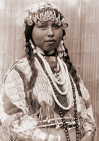
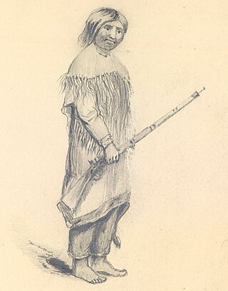
The Native American peoples of Oregon are the set of Indigenous peoples who have inhabited or who still inhabit the area delineated in today's state of Oregon in the Pacific Northwest region of the United States. While the state of Oregon currently maintains relations with nine federally recognized tribal groups, the state was previously home to a much larger number of autonomous tribal groups, which today either no longer exist or have been absorbed into these larger confederated entities. Six of the nine tribes gained federal recognition in the late 20th century, after undergoing the termination and restoration of their treaty rights starting in the 1950s.
The Western Oregon Indian Termination Act or Public Law 588, was passed in August 1954 as part of the United States Indian termination policy. It called for the termination of federal supervision over the trust and restricted property of numerous Native American bands and small tribes, all located west of the Cascade Mountains in Oregon. The act also called for disposition of federally owned property which had been bought for the administration of Indian affairs, and for termination of federal services which these Indians received under federal recognition. The stipulations in this act were similar to those of most termination acts.
Mary Peters (1852–1921) was an Umpqua woman who operated a ferry across the Rogue River.

Although the Confederate States of America dissolved at the end of the American Civil War (1861–1865), its battle flag continues to be displayed as a symbol. The modern display began during the 1948 United States presidential election when it was used by the Dixiecrats, a political party that opposed civil rights for African Americans. Further display of the flag was a response to the civil rights movement and the passage of federal civil rights laws in the 1950s and 1960s.

More than 160 monuments and memorials to the Confederate States of America and associated figures have been removed from public spaces in the United States, all but five since 2015. Some have been removed by state and local governments; others have been torn down by protestors.
44°56′20″N123°01′55″W / 44.93889°N 123.03200°W
| | This Oregon-related article is a stub. You can help Wikipedia by expanding it. |