Six Companies, Inc. was a joint venture of construction companies that was formed to build the Hoover Dam on the Colorado River in Nevada and Arizona.

Lake Mead is a reservoir formed by Hoover Dam on the Colorado River in the Southwestern United States. It is located in the states of Nevada and Arizona, 24 mi (39 km) east of Las Vegas. It is the largest reservoir in the US in terms of water capacity. Lake Mead provides water to the states of Arizona, California, and Nevada as well as some of Mexico, providing sustenance to nearly 20 million people and large areas of farmland.

Pah-Ute County is a former county in the northwest corner of Arizona Territory that existed from 1865 until 1871, at which point most of the area was transferred to Nevada. The remainder was merged into Mohave County. The majority of the territory is now in Clark County, Nevada, which includes the city of Las Vegas. Due to the transfer of most of the county's land to Nevada, Pah-Ute is sometimes referred to as Arizona's "Lost County". Pah-Ute is an historic spelling of the tribal name Paiute.

St. Thomas, Nevada is a ghost town in Clark County, Nevada, United States, near where the Muddy River flows into the Colorado River. St. Thomas was purchased by the US Federal Government and abandoned as the waters of Lake Mead submerged the town in the 1930s.
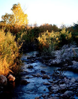
The Muddy River, formerly known as the Moapa River, is a short river located in Clark County, in southern Nevada, United States. It is in the Mojave Desert, approximately 60 miles (97 km) north of Las Vegas.
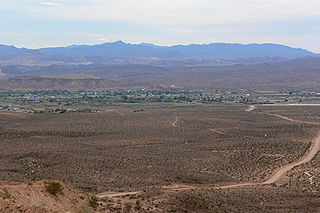
Overton is a community that is part of the unincorporated town of Moapa Valley in Clark County, Nevada. Overton is on the north end of Lake Mead. It is home to Perkins Field airport and Echo Bay Airport.

Las Vegas Bay is a bay at the western edge of Lake Mead in the U.S. state of Nevada. The bay is located within the Lake Mead National Recreation Area to the northeast of the city of Henderson, Nevada, near the junction of Lake Mead Drive and Lake Mead Boulevard. A public campground and boat access are available in Las Vegas Bay. Low water levels of Lake Mead have rendered the marina there inoperable, and it has moved to the Hemenway Boat Harbor, in the south end of the Boulder Basin. The launch ramp there has also been closed due to the water levels.

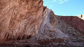
Frenchman Mountain is a mountain located east of Las Vegas, Nevada. Made up of rocks similar to those found on the bottom of the Grand Canyon, Frenchman Mountain formed when faulting elevated and tilted the rocks followed by erosion, giving it its sharp triangular profile. The mountain provides an example of the Great Unconformity with the tilted Paleozoic Tapeats Sandstone underlain by Paleoproterozoic Vishnu Schist, which is some of the oldest rock on the North American continent, having been created about two billion years ago.
The Black Mountains, a mid-Miocene formation, in Nevada are a series of rugged, arid rocky volcanic mountains ranging in elevations to 3310 ft. The range lies on the north shore of Lake Mead, at the southwest corner of the Overton Arm, about 25 mi south of Overton, Nevada.
Rioville, Nevada was a settlement founded by Latter-day Saints in what they thought was Utah Territory in 1869, now under Lake Mead and within Clark County, Nevada.

Callville is a former settlement of Clark County in the U.S. state of Nevada. Abandoned in 1869, it was submerged under Lake Mead when the Colorado River was dammed, Callville Bay retaining the name. At one time, it was noted to be the southernmost outpost of the Mormon settlement.
Hamblin Bay is a bay of Lake Mead on the Colorado River, to the east of Las Vegas and Callville Bay in the U.S. state of Nevada. It lies between Sandy Cove which lies to the west and Rotary Cove and Rufus Cove which lie to the east. Hamblin Bay is also a fault of the same name in the vicinity, which "strikes at a low angle to the easternmost mapped branch of the Las Vegas Shear Zone".
The Horse Spring Formation is a geologic formation in Nevada. It preserves fossils dating back to the Neogene period. The lower unit is conglomerate and the middle and upper are sandstone and freshwater limestone.
Callville Wash is an ephemeral stream or wash in Clark County, Nevada. It was named for Callville the riverport settlement founded in 1866, at its mouth where it had its original confluence with the Colorado River.
Boulder Wash is an ephemeral stream or wash in Clark County, Nevada. Its mouth is at its confluence with the Boulder Wash Cove of Lake Mead at an elevation 1,276 feet at when Lake Mead is at its full level. Currently as the reservoir is at a much lower level its mouth is found at approximately 36°10′07″N114°33′07″W. Its source is at 36°13′36″N114°31′22″W at an elevation of 2,841 feet in the Black Mountains. It flows down a canyon into the upper Pinto Valley southwestward before turning southeastward to Boulder Wash Cove.
West End Wash is an ephemeral stream or wash in Clark County, Nevada. Its mouth is at its confluence with the Callville Wash of Lake Mead at an elevation 1,250 feet at when Lake Mead is at its full level. Currently as the reservoir is at a much lower level its mouth is found at approximately 36°08′24″N114°42′57″W. Its source is at 36°15′55″N114°43′58″W at 3,083 feet in the Gale Hills.
Gypsum Wash is an ephemeral stream or wash in Clark County, Nevada. Gypsum Wash was originally a tributary of Las Vegas Wash before the formation of Lake Mead which submerged their confluence under Las Vegas Bay. Due to the lowering of the reservoir over recent years Gypsum Wash is once again a tributary of Las Vegas Wash, now exposed at 36°07′04″N114°50′54″W at an elevation of 1085 feet. When Las Vegas Bay is at its full level, Gypsum Wash flows into Lower Gypsum Wash Cove at 36°07′43″N114°51′26″W at an elevation of 1,204 feet.
Boulder Basin is the westernmost of the three basins occupied by the Lake Mead reservoir and lies within the boundaries of Clark County, Nevada and Mohave County, Arizona. It includes the area between Hoover Dam and the mouth of Boulder Canyon at Auxiliary Point. When the reservoir is full it reaches an elevation of 1,204 feet. It includes Las Vegas Bay, Swallow Bay, Callville Bay and Hamblin Bay.
The Thumb member of the Horse Spring Formation is a geologic formation in Nevada. It contains sandstone with beds of conglomerate and gypsum in the Neogene period.
Rio Virgen County is a former county in the U.S. state of Utah. It was established by the Territory of Utah on February 1869.

