
Churchill County is a county in the western U.S. state of Nevada. As of the 2010 census, the population was 24,877. Its county seat is Fallon. Named for Mexican–American War hero brevet Brigadier General Sylvester Churchill, the county was formed in 1861. Churchill County comprises the Fallon, NV Micropolitan Statistical Area. It is in northwestern Nevada. Churchill County is noteworthy in that it owns and operates the local telephone carrier, Churchill County Communications.

The Black Rock Desert is a semi-arid region of lava beds and playa, or alkali flats, situated in the Black Rock Desert–High Rock Canyon Emigrant Trails National Conservation Area, a silt playa 100 miles (160 km) north of Reno, Nevada that encompasses more than 300,000 acres (120,000 ha) of land and contains more than 120 miles (200 km) of historic trails. It is in the northern Nevada section of the Great Basin with a lakebed that is a dry remnant of Pleistocene Lake Lahontan.

Vya is a small ghost town located in Washoe County, in northwestern Nevada, United States. It is about 10 miles (16 km) east of the California state line, north of Forty Nine Canyon. Not much remains of the small town, which essentially died in the 1920s. Just two wooden buildings can still be seen—the Vya Post Office and Library. The Vya Post Office was in operation from September 1910 until October 1941. The settlement was named for Vya Wimer, the first European heritage baby born in the valley.
San Jacinto is a ghost town in along Salmon Falls Creek in northern Elko County, Nevada, United States. It is part of the Elko Micropolitan Statistical Area.
Belleville, Nevada, in Mineral County, Nevada, United States, was a mining town that rose up around the milling of ore shipped in from nearby mines. Today it is a ghost town.

The Soda Lakes are two lakes located northwest of Fallon, Nevada. They occupy two basaltic maar volcano craters which may have erupted in the last 1500 years. The larger lake, called Soda Lake or Big Soda Lake, is somewhat elongated, stretching 2 kilometers (1.2 mi) in length. The smaller one, Little Soda Lake, is 200 meters (660 ft) across. Considered to be a single volcano, the combined craters are young enough that future activity can't be ruled out. A geothermal power plant is located on the northeast flank of the volcano.
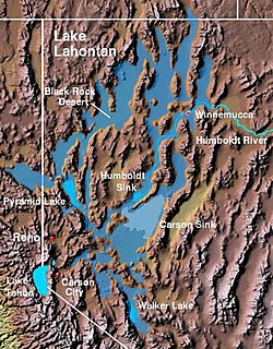
The Lahontan Valley is a basin in Churchill County, Nevada, United States. The valley is a landform of the central portion of the prehistoric Lake Lahontan's lakebed of 20,000-9,000 years ago. The valley and the adjacent Carson Sink represent a small portion of the lake bed. Humboldt Lake is to the valley's northeast. Pyramid Lake is west. Walker Lake is to the south. The valley is part of the larger Great Basin Desert, however during the California Gold Rush was valley often called the Forty Mile Desert.
Potts is a ghost town and abandoned ranching property in Monitor Valley, Nye County, Nevada, approximately 2 miles east of Nevada State Route 82.
Hazen is an unincorporated community in Churchill County, Nevada, United States, about 12 miles (19 km) southeast of Fernley and 16 miles (26 km) northwest of Fallon, on U.S. Route 50 Alternate.
Schellbourne, formerly known as Fort Schellbourne and Schell Creek Station is a ghost town located in the Schell Creek Range in White Pine County in Nevada, United States, located 43 miles (69 km) north of Ely. The town was a stopover along the Central Overland Route, Pony Express and original routing of the Lincoln Highway. It is today Nevada Historical Marker number 51. The site was listed on the National Register of Historic Places in 1972. Its boundaries were increased in 1977.

El Dorado Canyon is a canyon in southern Clark County, Nevada famed for its rich silver and gold mines. The canyon was named in 1857 by steamboat entrepreneur Captain George Alonzo Johnson when gold and silver was discovered here. It drains into the Colorado River at the former site of Nelson's Landing.

Fairview is a ghost town in Churchill County, Nevada, in the United States of America.
Excelsior is a ghost town in Elko County, in the U.S. state of Nevada.
Fairlawn is a ghost town in Elko County, in the U.S. state of Nevada.
Jungo is a ghost town located on Humboldt County Route 55, between Winnemucca, Nevada and Sulphur, Nevada. At one time, Jungo boasted a hotel, store, filling station and blacksmith's shop, though no buildings remain.
Eagleville is a former populated place in Mineral County, Nevada that is now a ghost town.
Leete is a ghost town in Churchill County, in the U.S. state of Nevada. A variant name was "Eagle Salt Works".
White Rock is an extinct town in Elko County, in the U.S. state of Nevada.
Willow Point is an extinct town in Humboldt County, in the U.S. state of Nevada. Willow Point is located in Paradise Valley, south of the town of Paradise Valley and about 20 miles northeast of Winnemucca.

Tenabo is a ghost town in Lander County, Nevada United States.
 Desert Lake, near Ragtown, Western Nevada, ca. 1867 by Timothy H. O'Sullivan
 Ragtown, Leeteville, St Clair, and Fallon Nevada as mapped in 1910. Leeteville location is where the original Ragtown was established. [5]
 Ragtown highway marker near Fallon


