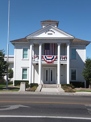
Churchill County is a county in the western U.S. state of Nevada. As of the 2020 census, the population was 25,516. Its county seat is Fallon. Named for Mexican–American War hero brevet Brigadier General Sylvester Churchill, the county was formed in 1861. Churchill County comprises the Fallon, NV Micropolitan Statistical Area. It is in northwestern Nevada. Churchill County is noteworthy in that it owns and operates the local telephone carrier, Churchill County Communications.
Ragtown, Nevada, is a Churchill County ghost town of an abandoned 1854 trading post west of Fallon.
Stone House is a ghost town in Humboldt County, Nevada, United States.
Nyala is an extinct town in Nye County, in the U.S. state of Nevada.

Fairview is a ghost town in Churchill County, Nevada, in the United States of America.
Dutton is a ghost town in Elko County, in the U.S. state of Nevada.
Fairlawn is a ghost town in Elko County, in the U.S. state of Nevada.
Thorne, Nevada is a rail junction and former town located in Mineral County, Nevada.
Rand is an extinct town in Mineral County, in the U.S. state of Nevada. The GNIS classifies Rand as a populated place with a "RR Locale" description. Rand was a station on the Carson and Colorado Railway.
Allred is a ghost town situated in Nye County, Nevada. A post office in the settlement opened on April 17, 1911 with Allen Oxborrow and George Kump as postmasters. The post office was closed more than a year later on October 31, 1912. There are no visible remains left of Allred.
Wahmonie was a mining town in Nevada. It was established as a gold mining camp in February 1928 and had a population of 500 by March. Peak population was reached that summer, with between 1000 and 1500 residents. Gold was not found in sufficient quantity to sustain the place, and the site was quickly abandoned. The post office was in operation from April 1928 until April 1929. Wahmonie was the last large mining rush in Nevada. The location was also known as Horn Silver Mine.
Eagleville is a former populated place in Mineral County, Nevada that is now a ghost town.
Bernice is a ghost town in Churchill County, in the U.S. state of Nevada. It was approximately 20 miles (32 km) northeast of Dixie Valley.
Leete is a ghost town in Churchill County, in the U.S. state of Nevada. A variant name was "Eagle Salt Works".
White Plains is a ghost town in Churchill County, in the U.S. state of Nevada.
Holbrook Junction is an unincorporated community in southeast Douglas County, in the U.S. state of Nevada. The community is at the intersection of US Route 395 and Nevada State Route 208. Topaz Lake lies on the Nevada - California state line two miles south of the community on Route 395.
Black Forest is an extinct town in Elko County, in the U.S. state of Nevada.

Gold Creek is an extinct town in Elko County, Nevada, United States.
White Rock is an extinct town in Elko County, in the U.S. state of Nevada.
Gilbert is a ghost town in Esmeralda County, in the U.S. state of Nevada.


