
This is an incomplete list of ghost towns in South Carolina . [1]
This is an incomplete list of ghost towns in South Carolina . [1]

Boone is a town in and the county seat of Watauga County, North Carolina, United States. Located in the Blue Ridge Mountains of western North Carolina, Boone is the home of Appalachian State University and the headquarters of the disaster and medical relief organization Samaritan's Purse. The population was 19,092 at the 2020 census.

Charleston is the most populous city in the U.S. state of South Carolina, the county seat of Charleston County, and the principal city in the Charleston metropolitan area. The city lies just south of the geographical midpoint of South Carolina's coastline on Charleston Harbor, an inlet of the Atlantic Ocean formed by the confluence of the Ashley, Cooper, and Wando rivers. Charleston had a population of 150,227 at the 2020 census. The population of the Charleston metropolitan area, comprising Berkeley, Charleston, and Dorchester counties, was estimated to be 849,417 in 2023. It ranks as the third-most populous metropolitan statistical area in the state, and the 71st-most populous in the United States.

Oconee County is the westernmost county in the U.S. state of South Carolina. As of the 2020 census, the population was 78,607. Its county seat is Walhalla and its largest community is Seneca. Oconee County is included in the Seneca, SC Micropolitan Statistical Area, which is also included in the Greenville-Spartanburg-Anderson, SC Combined Statistical Area. South Carolina Highway 11, the Cherokee Foothills National Scenic Highway, begins in southern Oconee County at Interstate Highway 85 at the Georgia state line.

Meggett is a town in Charleston County, South Carolina, United States. The population was 1,226 at the 2010 census. Meggett is part of the Charleston-North Charleston-Summerville metropolitan area.
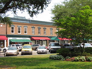
Camden is the largest city and county seat of Kershaw County, South Carolina. The population was 7,764 in the 2020 census, and the 2022 population estimate is 8,213. It is part of the Columbia, South Carolina, Metropolitan Statistical Area. Camden is the oldest inland city in South Carolina, and home to the Carolina Cup and the National Steeplechase Museum.

Westminster is a city in Oconee County, South Carolina, United States. The population was 2,418 at the 2010 census.

Kingstree is a city in and the county seat of Williamsburg County, South Carolina, United States. The population was 3,328 at the 2010 census.

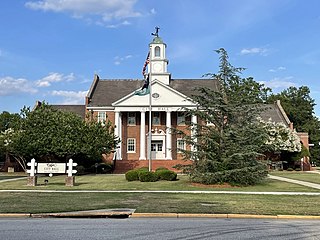
Fort Mill, also known as Fort Mill Township, is a town in York County, South Carolina, United States. It is a suburb of Charlotte, North Carolina. As of the 2020 census, the population of the town was 24,521. Some businesses and residents in the Indian Land community of neighboring Lancaster County share a Fort Mill mailing address, but the official town boundary extends only within York County.
Summerville is a town in the U.S. state of South Carolina situated mostly in Dorchester County, with small portions in Berkeley and Charleston counties. Summerville is seventh biggest city in the state. The town lies approximately five miles from the Ashley River. It is part of the Charleston-North Charleston-Summerville, SC Metropolitan Statistical Area. Summerville's population at the 2020 census was 50,915.
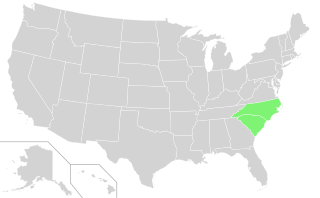
The Carolinas, also known simply as Carolina, are the U.S. states of North Carolina and South Carolina considered collectively. They are bordered by Virginia to the north, Tennessee to the west, and Georgia to the southwest. The Atlantic Ocean is to the east.

The Province of North Carolina, originally known as Albemarle Province, was a proprietary colony and later royal colony of Great Britain that existed in North America from 1712 to 1776.(p. 80) It was one of the five Southern colonies and one of the thirteen American colonies. The monarch of Great Britain was represented by the Governor of North Carolina, until the colonies declared independence on July 4, 1776.

The Anglo-Cherokee War, was also known from the Anglo-European perspective as the Cherokee War, the Cherokee Uprising, or the Cherokee Rebellion. The war was a conflict between British forces in North America and Cherokee bands during the French and Indian War.

WIS is a television station in Columbia, South Carolina, United States, affiliated with NBC and The CW. The station is owned by Gray Television, and maintains studios on Bull and Gervais Streets in downtown Columbia and a transmitter on Rush Road in rural southwestern Kershaw County, outside Lugoff.

North Georgia is the northern hilly/mountainous region in the U.S. state of Georgia. At the time of the arrival of settlers from Europe, it was inhabited largely by the Cherokee. The counties of north Georgia were often scenes of important events in the history of Georgia. It was the site of many American Civil War battles, including the Battle of Lookout Mountain and the Battle of Chickamauga, leading up to the Atlanta Campaign. Today, particularly in the northeast portion of the region, tourism sustains the local economy.
Rougemont is an unincorporated community and census-designated place (CDP) in Durham and Person counties, North Carolina, United States. The population of the CDP was 978 at the 2010 census. An act to incorporate Rougemont as a town was introduced to the North Carolina General Assembly in 2011.

Western North Carolina is the region of North Carolina which includes the Appalachian Mountains; it is often known geographically as the state's Mountain Region. It contains the highest mountains in the Eastern United States, with 125 peaks rising to over 5,000 feet in elevation. Mount Mitchell at 6,684 feet, is the highest peak of the Appalachian Mountains and mainland eastern North America. The population of the 23 most commonly associated counties for the region, as measured by the 2020 U.S. Census, is 1,149,405. The region accounts for approximately 11% of North Carolina's total population.

Keowee was a Cherokee town in the far northwest corner of present-day South Carolina. It was the principal town of what were called the seven Lower Towns, located along the Keowee River. Keowee was situated on the Lower Cherokee Traders' Path, part of the Upper Road through the Piedmont. In 1752 the Cherokee established New Keowee Town nearby, off the traders' path but in a more defensible location.

North Carolina Highway 96 (NC 96) is a 112-mile-long (180 km) primary state highway in the U.S. state of North Carolina. It is a predominantly rural highway that travels north-south, from NC 55, west of Newton Grove, to the Virginia state line near Virgilina, Virginia, where it continues on as Virginia State Route 96. It also connects the cities of Smithfield, Selma, Zebulon, Youngsville and Oxford.

South Carolina Highway 11 (SC 11), also known as the Cherokee Foothills Scenic Highway, is a 119.850-mile (192.880 km) state highway through the far northern part of the U.S. state of South Carolina, following the southernmost peaks of the Blue Ridge Mountains. The route is surrounded by peach orchards, quaint villages, and parks. It is an alternative to Interstate 85 (I-85) and has been featured by such publications as National Geographic, Rand McNally, and Southern Living.

The historic Cherokee settlements were Cherokee settlements established in Southeastern North America up to the removals of the early 19th century. Several settlements had existed prior to and were initially contacted by explorers and colonists of the colonial powers as they made inroads into frontier areas. Others were established later.