Bodie is a ghost town in the Bodie Hills east of the Sierra Nevada mountain range in Mono County, California, United States. It is about 75 miles (121 km) southeast of Lake Tahoe, and 12 mi (19 km) east-southeast of Bridgeport, at an elevation of 8,379 feet (2554 m). Bodie became a boom town in 1876 after the discovery of a profitable vein of gold; by 1879 it had established 2,000 structures with a population of roughly 8,000 people.

Palisade is located in Eureka County in the northeastern section of the state of Nevada, in the western United States. It is about 10 miles (16 km) south of Carlin, and about 33 miles (53 km) southwest of Elko. Although now a virtual ghost town, it had a rich history following construction of the Transcontinental Railroad. The town takes its name from Palisade Canyon, an important obstacle to the construction and operation of the railroad, which lies to the west.

Belmont is a ghost town in Nye County, Nevada, United States along former State Route 82. The town is a historic district listed in the National Register of Historic Places. It is Nevada Historical Marker number 138.

Tuscarora is an unincorporated community in Elko County, Nevada, United States. The community lies on the east side of the Tuscarora Mountains approximately 40 miles north of Carlin. Tuscarora is part of the Elko Micropolitan Statistical Area. Far from being a ghost town, as several websites proclaim, Tuscarora is home to two schools, a library, a post office and a bar and grill, as well as homes for its very much alive residents.

Gold Point, Nevada is a well-preserved historic mining town in Esmeralda County, Nevada. The community was named after the local gold-mining industry. Gold Point is the southern terminus of Nevada State Route 774. Its current population is about seven.

Cherry Creek is a historic mining town located in northern White Pine County, in northeastern Nevada in the western United States. It is a census county division (CCD), with a population at the 2010 census of 72.

Columbus was a borax mining boom town in Esmeralda County. Its remnants are located on the edge of the Columbus Salt Marsh.

Charleston is a ghost town in Cochise County in the southeastern part of the U.S. state of Arizona. It was occupied from the late-1870s through the late-1880s, and was located in what was then known as the Arizona Territory. Located on the west bank of the San Pedro River, Charleston's economy was based on milling silver ore mined from nearby Tombstone in the community of Millville, located directly across the river.
You Bet is a small unincorporated community in Nevada County, California. You Bet is located in the Sierra Nevada foothills, 7 miles (11.3 km) east of Grass Valley and 5.5 miles (8.9 km) northeast of Chicago Park.
French Corral is an unincorporated community approximately five miles west of California State Highway 49 in Nevada County, California, United States.
Alpha was a gold mining town in Nevada County, located about 2 miles southeast of the town of Washington, California and about 15 miles northeast of Nevada City, California. It lay at an elevation of 4120 feet, about 2 miles below the South Yuba River and just west of Scotchman Creek.

Harshaw is a ghost town in Santa Cruz County in the southeastern part of the U.S. state of Arizona. The town was settled in the 1870s, in what was then Arizona Territory. Founded as a mining community, Harshaw is named after the cattleman-turned-prospector David Tecumseh Harshaw, who first successfully located silver in the area. At the town's peak near the end of the 19th century, Harshaw's mines were among Arizona's highest producers of ore, with the largest mine, the Hermosa, yielding approximately $365,455 in bullion over a four-month period in 1880.

Ruby Hill is a ghost town in Eureka County, in the central part of the U.S. state of Nevada, approximately 2.6 mi (4.2 km) west of the town of Eureka, Nevada. In 1910, the Ruby Hill Railroad was washed out, after which there were only three businesses in town.

Dun Glen is a ghost town in Pershing County, Nevada, United States, 9 miles northeast of Mill City. Established in 1862, the mining camp soon became one of the largest towns in northern Nevada. By 1880, mining had declined and the town was abandoned. With a silver discovery in the area in 1908, the settlement attracted people and was re-named Chafey. Chafey was abandoned when mining operations stopped in 1913.

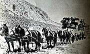
Treasure Hill is an east-jutting spur of the White Pine Range of White Pine County in the east central region of the U.S. state of Nevada. It lies to the east of Mount Hamilton and to the northwest of Mokomoke Hill. It is noted for a silver mining boom in the late 1860s: between 1867 and 1880, the total production from area mines was valued at $20 million. The rush drew thousands to new towns such as Hamilton, situated at the northern base of the hill, and Treasure City, located near its peak, 2.5 miles (4.0 km) from Hamilton.
Rockland is a ghost town in Lyon County, Nevada, in the United States. The town that grew up around the mine was named Rockland, probably for the rocky cliffs that surrounded the area.

Como is a ghost town in Lyon County, Nevada, in the United States.
Maitland, originally called Garden City and sometimes misspelled Midland, is a ghost town in Lawrence County, South Dakota, United States. It was a mining community that boomed during the Black Hills Gold Rush, but was abandoned by about 1915.
Rochford is an unincorporated community in Pennington County, South Dakota, United States. It is not tracked by the U.S. Census Bureau.
Roubaix, formerly known as Perry or Lewisville, is an unincorporated community in Lawrence County, South Dakota, United States. It is not monitored by the U.S. Census Bureau.