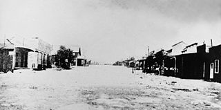
Palisade is located in Eureka County in the northeastern section of the state of Nevada, in the western United States. It is about 10 miles (16 km) south of Carlin, and about 33 miles (53 km) southwest of Elko. Although now a virtual ghost town, it had a rich history following construction of the Transcontinental Railroad. The town takes its name from Palisade Canyon, an important obstacle to the construction and operation of the railroad, which lies to the west.

Hamilton is an abandoned mining town located in the White Pine Range, in western White Pine County, Nevada, United States.

Belmont is a ghost town in Nye County, Nevada, United States along former State Route 82. The town is a historic district listed in the National Register of Historic Places. It is Nevada Historical Marker number 138.

Delamar, Nevada, nicknamed The Widowmaker, is a ghost town in central eastern Nevada, USA along the east side of the Delamar Valley. During its heyday, primarily between 1895 and 1900, it produced $13.5 million in gold.

Gold Point, Nevada is a well preserved ghost town in Esmeralda County, Nevada. The GNIS classifies it as a populated place. The community was named after the local gold-mining industry. Gold Point is the southern terminus of Nevada State Route 774.

Cherry Creek is a historic mining town located in northern White Pine County, in northeastern Nevada in the western United States. It is a census county division (CCD), with a population at the 2010 census of 72.

Vanderbilt was a short-lived gold mining town located in San Bernardino County, California, United States. It existed between 1893 and 1895. At its peak it may have had a population of about 400 people.
You Bet is a small unincorporated community in Nevada County, California. You Bet is located in the Sierra Nevada foothills, 7 miles (11.3 km) east of Grass Valley and 5.5 miles (8.9 km) northeast of Chicago Park.
Gold Hill, in Grass Valley, California, was the site of one of the first discoveries of quartz gold in California. While quartz gold was also found in other areas of Nevada County, California during the same time, it is this find near Wolf Creek that led to quartz-mining frenzy and subsequent creation of the Gold Country quartz-mining industry. The location is honored as a California Historical Landmark.
Hunt's Hill is a former mining camp in Nevada County, California, United States. Hunt's Hill was located in the Sierra Nevada foothills about 6 miles in a straight line southeast of Nevada City and about 2 miles northwest of You Bet, on the north side of Greenhorn Creek, not far from the present intersection of Red Dog and Buckeye Roads. Hunt’s Hill was founded in 1852 by a miner named Hunt. It was located on one of the deepest parts of the rich Blue Lead channel of gold-bearing gravel. In 1855, one of the mining claims established by some French miners, was “jumped". During the fight, one of the French miners lost an eye. Thereafter, that mine, and sometimes the town, were called Gouge Eye. By 1857, the town boasted two saloons, a hotel, a blacksmith and stable, a butcher shop, a boot and shoe store, and several grocery stores. In 1858, a stage line from Nevada City arrived. In 1866, seven cement mills for extracting gold from the “blue cement” were operating in the area. By 1880, the town was reduced to a combined store and saloon and a few houses. In 1895, one directory summed up the state of the community thus: "At the present time there is not much doing there." Since that same directory identified the town's justice of the peace and constable, what little happened must have been interesting. Today, it is just a historic site.
Poeville, also known as Peavine until 1863, is the site of a historical mining town, established in 1864. John Poe, a professional promoter from Michigan allegedly related to Edgar Allan Poe, discovered rich gold and silver veins in 1862 on the slopes of Peavine Mountain. After the discovery of ore, Poe announced that the veins comprised the next Comstock Lode; he presented extracted ore at the state fair of 1864 as rich in content. As a result, the former mining camp, called Poe City (Poeville) or Podunk (Poedunk), grew to 200 people by 1864. Ore production in the mining district and population peaked around 1873-1874 with several hundred people living in town, supported by three hotels and a post office. The post office, named "Poeville", operated between September 1, 1874, and March 24, 1878.
Silver Reef is a ghost town in Washington County, Utah, United States, about 15 miles (24 km) northeast of St. George and 1 mile (1.6 km) west of Leeds. Silver Reef was established after John Kemple, a prospector from Nevada, discovered a vein of silver in a sandstone formation in 1866. At first, geologists were uncertain about Kemple's find because silver is not usually found in sandstone. In 1875, two bankers from Salt Lake City sent William Barbee to the site to stake mining claims. He staked 21 claims, and an influx of miners came to work Barbee's claims and to stake their own. To accommodate the miners, Barbee established a town called Bonanza City. Property values there were high, so several miners settled on a ridge to the north of it and named their settlement "Rockpile". The town was renamed Silver Reef after silver mines in nearby Pioche closed and businessmen arrived.

Dun Glen is a ghost town in Pershing County, Nevada, United States, 9 miles northeast of Mill City. Established in 1862, the mining camp soon became one of the largest towns in northern Nevada. By 1880, mining had declined and the town was abandoned. With a sliver discovery in the area in 1908, the settlement attracted people and was re-named Chafey. Chafey was abandoned when mining operations stopped in 1913.

Gaston is the site of a former mining community in Nevada County, California. Gaston lies at an elevation of 5062 feet on the Gaston Ridge. The Gaston Ridge historically, was often referred to as God’s Country, because of its wild and somewhat inaccessible beauty. Gaston is located 3.25 miles (5.2 km) south of Graniteville and about 4 miles northeast of the town of Washington. It is near the intersection of what are now Gaston and Hoosier Roads, in the Tahoe National Forest.

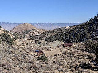
Vanderbilt is a ghost town in Eureka County, in the western state of Nevada, in the United States.

Treasure Hill is an east-jutting spur of the White Pine Range of White Pine County in the easte central of the U.S. states of Nevada. Hamilton is situated at the northern base of the hill while Treasure City is situated on the hill, 2.5 miles (4.0 km) from Hamilton. It lies to the east of Mount Hamilton and to the northwest of Mokomoke Hill. It was noted for its silver mining from 1867 until the late 1880s. Between 1867 and 1880, the total production from the mines of the Treasure Hill was valued at $20 million. By early 1881 the mining activity had collapsed as the mining of the hill was dependent on the deposits and not on the lasting silver bearing geological veins. As a result, by 1888 there were only 24 people living there with the principal towns of Hamilton at the base of the hill, the Treasure City on the hill side and the Shermantown went into oblivion.
Atwood is a former mining settlement located 35 miles (56 km) northeast of Mina in Nye County, Nevada. Founded in 1901, it was the most important mining village in the Fairplay Mining District, that was called "Atwood Mining District" as well. After Atwood was totally deserted in 1908, the settlement revived in 1914. The last resident left the mining settlement in 1959. Currently, only one foundation and fragments of glass remain.

Seven Troughs is a ghost town in Pershing County, Nevada, United States.

Cortez is a ghost town in Lander County, in the U.S. state of Nevada. The GNIS classifies it as a populated place.