Wabuska, Nevada | |
|---|---|
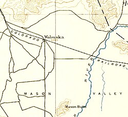 Wabuska site in 1894 | |
 | |
| Coordinates: 39°08′38″N119°11′00″W / 39.14389°N 119.18333°W | |
| Elevation | 1,309 m (4,295 ft) |
| Postal code | 89447 |


Wabuska is an unincorporated community in Lyon County, Nevada, United States. [1] The zip code is 89447, which it shares with nearby Yerington.
Contents
Wabuska (Washo language, White Grass [2] ) was established in the early 1870s. A post office was opened on September 18, 1874. [3] In 1881, the town served as the principal Mason Valley supply center on the newly constructed Carson and Colorado Railroad of a line that went from Hazen to Mina. [3] When copper was discovered in Mason Valley, the town became the northern terminus of the new Nevada Copper Belt Railroad, built 1909–1911. Wabuska waned with declining mining activity in the 1920s. [4]
Several buildings from Wabuska, most notably the Wabuska Railroad Station, were relocated to Carson City and incorporated as the Nevada State Railroad Museum.
