
Ludwig, Nevada is a ghost town in Lyon County, Nevada, United States. [1] Mining for gypsum at the site resumed in 2013. [2]
Ludwig, Nevada is a ghost town in Lyon County, Nevada, United States. [1] Mining for gypsum at the site resumed in 2013. [2]
Ludwig was part of the Yerington mining district known for its copper ore production. [3] The town was named for John D. Ludwig, a "California Indian fighter" affiliated with the Trinity Rangers. [4] The town was big enough from 1911 to 1932 to warrant its own post office. [4] At its peak the town had about 1,000 residents. [2]
The previous post office in the vicinity was called Morningstar. [5]
According to the Nevada Appeal, "The site features several concrete mill structures, many of which were painted with Egyptian symbols since the mines closed...the site is not safe for members of the public, and people should avoid mines whether they are active or closed." [2]
Among other attractions near Ludwig was a stop on the Nevada Copper Belt Railroad that also provided access to the Smith Valley Hot Springs resort. The resort didn't last long but the pool survived; local high school kids regularly visited "the plunge" in the 1940s. [6] In 1968 a newspaper columnist reported that the railroad "built a concrete swimming pool to catch the hot springs waters. Years later, after railroad, accommodations and all are long gone, the hot springs and the pool are still there, although surrounded by a fence that can be outwitted." [7]

Blue Diamond is a census-designated place (CDP) in Clark County, Nevada, United States. The population was 268 at the 2020 census.

Battle Mountain is an unincorporated town in and the county seat of Lander County, Nevada, United States. The population was 3,705 at the 2020 census. Its primary economic base is gold mining and, to a lesser extent, legalized gambling.
Beatty is an unincorporated town along the Amargosa River in Nye County, Nevada, United States. U.S. Route 95 runs through the town, which lies between Tonopah, about 90 miles (140 km) to the north and Las Vegas, about 120 miles (190 km) to the southeast. State Route 374 connects Beatty to Death Valley National Park, about 8 miles (13 km) to the west.

Ely is the largest city and county seat of White Pine County, Nevada, United States. Ely was founded as a stagecoach station along the Pony Express and Central Overland Route. In 1906 copper was discovered. Ely's mining boom came later than the other towns along US 50. The railroads connecting the transcontinental railroad to the mines in Austin, Nevada and Eureka, Nevada have long been removed, but the railroad to Ely is preserved as a heritage railway by the Nevada Northern Railway and known as the Ghost Train of Old Ely. As of the 2020 census, the population was 3,924.

The Black Rock Desert is a semi-arid region of lava beds and playa, or alkali flats, situated in the Black Rock Desert–High Rock Canyon Emigrant Trails National Conservation Area, a silt playa 100 miles (160 km) north of Reno, Nevada that encompasses more than 300,000 acres (120,000 ha) of land and contains more than 120 miles (200 km) of historic trails. It is in the northern Nevada section of the Great Basin with a lakebed that is a dry remnant of Pleistocene Lake Lahontan.
Empire is an unincorporated community and census-designated place (CDP) in Washoe County, Nevada, with a population estimated at 65 (2021). Prior to the 2010 census it was part of the Gerlach–Empire census-designated place, it is now part of the Reno–Sparks Metropolitan Statistical Area. The nearest town, Nixon, is 60 miles (97 km) to the south on a reservation owned by the Pyramid Lake Paiute Tribe.

The Gold Country is a historic region in the northern portion of the U.S. state of California, that is primarily on the western slope of the Sierra Nevada. It is famed for the mineral deposits and gold mines that attracted waves of immigrants, known as the 49ers, during the 1849 California Gold Rush.

Rhyolite is a ghost town in Nye County, in the U.S. state of Nevada. It is in the Bullfrog Hills, about 120 miles (190 km) northwest of Las Vegas, near the eastern boundary of Death Valley National Park.

Mound House is a small unincorporated community in Lyon County, Nevada on U.S. Route 50 that is situated between Nevada's capital, Carson City, and Dayton. Its elevation is 4,974 feet (1,516 m). It is in Lyon County, one of eight Nevada counties that allow for legalized prostitution, and is home to four brothels.

Arden, Nevada was an unincorporated community in Clark County, Nevada. The area is now part of the town of Enterprise. Located about 7 miles (11 km) southwest of Las Vegas, the area is experiencing rapid growth in housing development on land formerly owned by the Bureau of Land Management.
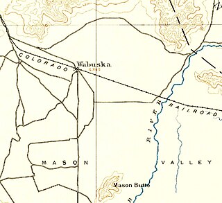
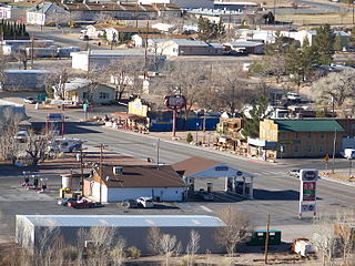
Wabuska is an unincorporated community in Lyon County, Nevada, United States. The zip code is 89447, which it shares with nearby Yerington.

Ivanpah was a short-lived silver mining town located in San Bernardino County, California, United States. It was founded in 1869 and existed until at least the mid-1880s.
Spenceville was a ranching, farming and mining community located in the southwestern part of Nevada County, California, on Spenceville Road just east of Waldo Road, about 17 miles from Grass Valley. Its elevation was about 400 feet. The former townsite is now part of the Spenceville Wildlife Area.

Bennettville is a former settlement and ghost town in Mono County, California. It was located on Mine Creek 4 mi (6.4 km) east-southeast of Mount Conness.
Poeville, also known as Peavine until 1863, is the site of a historical mining town, established in 1864. John Poe, a professional promoter from Michigan allegedly related to Edgar Allan Poe, discovered rich gold and silver veins in 1862 on the slopes of Peavine Mountain. After the discovery of ore, Poe announced that the veins comprised the next Comstock Lode; he presented extracted ore at the state fair of 1864 as rich in content. As a result, the former mining camp, called Poe City (Poeville) or Podunk (Poedunk), grew to 200 people by 1864. Ore production in the mining district and population peaked around 1873-1874 with several hundred people living in town, supported by three hotels and a post office. The post office, named "Poeville", operated between September 1, 1874, and March 24, 1878. As of 2010 the population of the community is 0.
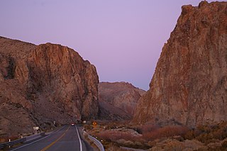
Wilson Canyon is a gorge cut by the Walker River through a series of volcanic cliffs. The canyon is located 13 miles (21 km) west of Yerington, along Nevada State Route 208. It is managed by the U.S. Bureau of Land Management.
Barnwell, originally a rail camp named Summit, then Manvel, was a former railhead serving local mining camps, now a ghost town, in San Bernardino County, California. It lies at an elevation 4806 feet in the New York Mountains.
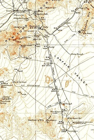
California Eastern Railway, is a defunct 45-mile (72 km) short-line railroad that operated from 1902 - 1911. The railroad ran from Goffs, California, to Ivanpah. It was first a private line operated by a mining company, that was acquired by the Atchison, Topeka and Santa Fe Railway.

Carson Hot Springs is a natural hot spring located in Carson City, Nevada, in the Eagle Valley. The spring emits approximately 60 US gallons (230 L) of 120 °F (49 °C) geothermally heated groundwater per minute, and is the largest hot spring in the Eagle Valley. The groundwater originates at 6.6 miles (10.6 km) below the Earth's surface, and the pools at the site are filled with water pumped from the spring. Today, it is a resort that provides private indoor soaking areas, an outdoor swimming pool, massage and dining.
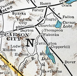
The Nevada Copper Belt Railroad was a railroad in the state of Nevada connecting Nevada-Douglas Copper Company mining facilities to the Southern Pacific's former Carson and Colorado Railway subsidiary at Wabuska, Nevada. The railroad was built south from Wabuska to the Walker River at Mason, Nevada in 1910, and began operations on 1 March. Railroad construction then proceeded up the West Walker River canyon from Mason to leave the river at Hudson reaching the Nevada-Douglas Copper Company mine at Ludwig on 1 November 1911. Rails also extended 2.54 miles (4.09 km) north from Wabuska to a smelter at Thompson. Agricultural products from irrigated ranches along the Walker River provided revenues in addition to the ore traffic.
38°57′20″N119°16′45″W / 38.95556°N 119.27917°W
Municipalities and communities of Lyon County, Nevada, United States | ||
|---|---|---|
| Cities |  | |
| CDPs | ||
| Other communities | ||
| Ghost towns | ||
| Indian reservation | ||
| | This Nevada state location article is a stub. You can help Wikipedia by expanding it. |