Benson, Louisiana

Last updated

Benson, Louisiana
USA Louisiana location map.svg
Red pog.svg
Benson, Louisiana
Usa edcp location map.svg
Red pog.svg
Benson, Louisiana
Coordinates: 31°51′59″N93°41′38″W / 31.86639°N 93.69389°W / 31.86639; -93.69389
Country United States
State Louisiana
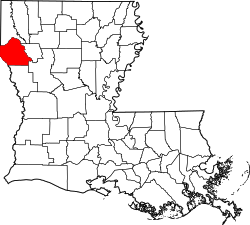
Parish DeSoto
Elevation
256 ft (78 m)
Time zone UTC-6 (Central (CST))
  Summer (DST) UTC-5 (CDT)
Area code 318
GNIS feature ID542982 [1]

Benson is an unincorporated community in DeSoto Parish, Louisiana, United States. [1] [2]

Located approximately halfway between Mansfield and Converse on the Kansas City Southern Railroad, it is an historic sawmill town. [3]

Notes

  1. 1 2 "Benson, Louisiana". Geographic Names Information System . United States Geological Survey, United States Department of the Interior.
  2. Benson Topo Map in De Soto County LA
  3. Benson, Louisiana


Related Research Articles

<span class="mw-page-title-main">Hernando de Soto</span> Spanish explorer and conquistador

Hernando de Soto was a Spanish explorer and conquistador who was involved in expeditions in Nicaragua and the Yucatan Peninsula. He played an important role in Francisco Pizarro's conquest of the Inca Empire in Peru, but is best known for leading the first European expedition deep into the territory of the modern-day United States. He is the first European documented as having crossed the Mississippi River.

<span class="mw-page-title-main">Sabine Parish, Louisiana</span> Parish in Louisiana, United States

Sabine Parish is a parish located in the U.S. state of Louisiana. As of the 2020 census, the population was 22,155. The seat of the parish is Many.

<span class="mw-page-title-main">DeSoto Parish, Louisiana</span> Parish in Louisiana, United States

DeSoto Parish is a parish located in the U.S. state of Louisiana. The parish was formed in 1843. At the 2020 U.S. census, the population was 26,812. Its parish seat is Mansfield. DeSoto Parish is part of the Shreveport–Bossier City metropolitan statistical area.

<span class="mw-page-title-main">Keachi, Louisiana</span> Town in Louisiana, United States

Keachi is a town in DeSoto Parish, Louisiana, United States. The population was 295 at the 2010 census. It is part of the Shreveport–Bossier City Metropolitan Statistical Area.

<span class="mw-page-title-main">Logansport, Louisiana</span> Town in Louisiana, United States

Logansport is a town in western DeSoto Parish adjacent to the Sabine River in western Louisiana, United States. The population was 1,340 in 2020. It is part of the Shreveport–Bossier City metropolitan statistical area.

<span class="mw-page-title-main">Mansfield, Louisiana</span> City in Louisiana, United States

Mansfield is a small city in, and the parish seat of, DeSoto Parish, Louisiana, United States. Mansfield is part of the Shreveport–Bossier City metropolitan statistical area, with a 2020 population of 4,714.

<span class="mw-page-title-main">Stonewall, Louisiana</span> Town in Louisiana, United States

Stonewall is a town in northern DeSoto Parish, Louisiana, United States. The population was 1,814 at the 2010 census, increasing to 2,273 in 2020. It is part of the Shreveport–Bossier City metropolitan statistical area.

DeSoto County is the name of two counties and one parish in the United States of America:

<span class="mw-page-title-main">Joseph Barton Elam</span> American politician

Joseph Barton Elam, Sr., was a two-term Democratic U.S. representative for Louisiana's 4th congressional district, whose service corresponded with the administration of U.S. President Rutherford B. Hayes.

USS <i>De Soto County</i>

USS De Soto County (LST-1171) was a De Soto County-class tank landing ship built for the United States Navy during the late 1950s. The lead ship of her class of seven, she was named after counties in Florida, Louisiana, and Mississippi, the only U.S. Naval vessel to bear the name.

<span class="mw-page-title-main">Newt V. Mills</span> American politician

Newt Virgus Mills was an American educator, businessman, and politician who served three terms as a U.S. Representative in the first half of the 20th century for Louisiana's 5th congressional district, based in Monroe, Louisiana.

USS <i>General Lyon</i> Cargo ship of the United States Navy

USS General Lyon, originally the De Soto, was recaptured from the Confederate States of America and renamed USS De Soto, and then USS General Lyon, after Brigadier General Nathaniel Lyon.

Kingston is an unincorporated community in DeSoto Parish, Louisiana, United States. It is located approximately 16 miles south of Shreveport near the intersection of Louisiana highways 5 and 175.

<span class="mw-page-title-main">Frierson, Louisiana</span> Census-designated place in Louisiana, United States

Frierson is an unincorporated community and census-designated place (CDP) in DeSoto Parish, Louisiana, United States. It is located approximately 3 miles (5 km) north of Interstate 49 along Louisiana State Highway 175.

Grand Bayou is an unincorporated community in west central Red River Parish, Louisiana, United States. It is located near the intersection of Louisiana Highway 1 and U.S. Highway 84. The community can also be reached by using exit 172 of Interstate 49 in De Soto Parish and traveling north into Red River Parish.

<span class="mw-page-title-main">National Register of Historic Places listings in DeSoto Parish, Louisiana</span>

This is a list of the National Register of Historic Places listings in DeSoto Parish, Louisiana.

<span class="mw-page-title-main">Gloster, Louisiana</span> Census-designated place in Louisiana, United States

Gloster is an unincorporated community and census-designated place (CDP) in DeSoto Parish, Louisiana, United States. As of the 2010 census it had a population of 94.

Pelican is an unincorporated community in DeSoto Parish, Louisiana, United States. The community is at the junction of Louisiana Highways 483 and 513, 12.6 miles (20.3 km) south-southeast of Mansfield and 30 miles (48 km) north-northwest of Natchitoches. Pelican has a post office with ZIP code 71063.

<span class="mw-page-title-main">1952 United States presidential election in Louisiana</span> Election in Louisiana

The 1952 United States presidential election in Louisiana took place on November 4, 1952, as part of the 1952 United States presidential election. State voters chose ten representatives, or electors, to the Electoral College, who voted for president and vice president.

Wemple is an unincorporated community in DeSoto Parish, Louisiana, United States. The community is on Louisiana Highway 510 8 miles (13 km) west of Coushatta.