Related Research Articles

Krotz Springs is a town in St. Landry Parish, Louisiana, United States, on the Atchafalaya River. The population was 1,198 at the 2010 census, down from 1,219 in 2000. It is part of the Opelousas–Eunice Micropolitan Statistical Area.

Melville is a town in St. Landry Parish, Louisiana, United States. The population was 1,041 at the 2010 census. It is part of the Opelousas−Eunice Micropolitan Statistical Area. It was founded in 1889 and is known as the Atchafalaya River Catfish Capital of Louisiana.

Paradise Township is a civil township in the south of Grand Traverse County in the U.S. state of Michigan. The population was 4,952 at the 2020 census, an increase from 4,713 at the 2010 census. Paradise Township is home to the village of Kingsley.

Atlantic City is a census-designated place (CDP) in Fremont County, Wyoming, United States. The population was 37 at the 2010 census. The community is a small mining settlement in a gulch near South Pass in southwestern Wyoming. It was founded as a mining camp following the 1867 gold rush in the region. The town declined following the end of the placer gold rush in the early 1870s, but continued to exist as advances in mining technology allowed further extraction of gold. From the 1960s until 1983, it was the location of US Steel iron ore mine. The town is accessible by gravel roads from nearby Wyoming Highway 28.

Seymour is a town in Outagamie County, Wisconsin, United States. The population was 1,216 at the 2000 census. The City of Seymour is located within the town. The unincorporated community of Isaar, Wisconsin is also located in the town. The ghost town of Lime Rock was also located partially in the town.
Bayou Teche is a 125-mile-long (201 km) waterway in south central Louisiana in the United States. Bayou Teche was the Mississippi River's main course when it developed a delta about 2,800 to 4,500 years ago. Through a natural process known as deltaic switching, the river's deposits of silt and sediment cause the Mississippi to change its course every thousand years or so.

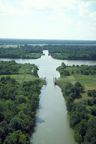
The Atchafalaya River is a 137-mile-long (220 km) distributary of the Mississippi River and Red River in south central Louisiana in the United States. It flows south, just west of the Mississippi River, and is the fifth largest river in North America, by discharge. The name Atchafalaya comes from Choctaw for 'long river', from hachcha, 'river', and falaya, 'long'.

The Atchafalaya Basin, or Atchafalaya Swamp, is the largest wetland and swamp in the United States. Located in south central Louisiana, it is a combination of wetlands and river delta area where the Atchafalaya River and the Gulf of Mexico converge. The river stretches from near Simmesport in the north through parts of eight parishes to the Morgan City southern area.
Berwick Bay is the section of the Lower Atchafalaya River in Louisiana from Morgan City north to Sixmile Lake. U.S. Route 90 crosses Berwick Bay connecting the town of Berwick on the west bank of the Atchafalaya to Morgan City on the east bank. There is also a Southern Pacific vertical lift bridge connecting the two municipalities. This stretch of water lends its name to Vessel Traffic Service Berwick Bay which manages the waters south of 29°45' N., west of 91°10' W., north of 29°37' N., and east of 91°18' W. These waters include the junction of the Gulf Intracoastal Waterway, the Port Allen-Morgan City Alternate Route and several tributary bayous. Narrow bridge openings and a swift river current require one-way traffic flow through the bridges. VTS Berwick Bay is unique among United States Coast Guard Vessel Traffic Services because it maintains direct control of vessel traffic.
Elliot City is a ghost town that was located in Pointe Coupee Parish's 10th Ward, approximately 6 miles west of Livonia, Louisiana United States. The site of the town itself is located at coordinates 30.555942, -91.662475, and is covered or partially covered by the current U.S. Route 190 roadway.
East Krotz Springs is a ghost town that was located in Pointe Coupee Parish's 1st Ward, approximately 12 miles west of Livonia, Louisiana, United States. The site of the town itself is located at coordinates 30°32'12.87"N, 91°44'24.59"W, and is abandoned. United States Geological Survey maps from 1948 show the town to be located on the east bank of the Atchafalaya River at the mouth of Bayou Sherman, directly across from Krotz Springs, south of the railroad bridge.
Torras is the name of a former town in the extreme northeastern corner of Pointe Coupee Parish, Louisiana, United States. The town was located along either side of the Texas & Pacific Railroad at its juncture with Lower Old River. The Mississippi River is located just to the east and the juncture of the Red and Atchafalaya Rivers just to the west.

Betteravia was a community in northern Santa Barbara County, California on Betteravia Road, six miles west of Santa Maria. It is notable as a rare ghost town on the Central Coast of California.
Bayou Chene was previously a small unincorporated community in St. Martin Parish, Louisiana, United States. The community was located in the Atchafalaya Basin.
The Atchafalaya National Wildlife Refuge is located about 30 miles (48 km) west of Baton Rouge, Louisiana, and one mile (1.6 km) east of Krotz Springs, Louisiana, lies just east of the Atchafalaya River. In 1988 under the administration of Governor Foster the "Atchafalaya Basin Master Plan" was implemented that combined the 11,780-acre (4,770 ha) Sherburne Wildlife Management Area (WMA), the 15,220-acre (6,160 ha) Atchafalaya National Wildlife Refuge, and the 17,000-acre (6,900 ha) U.S. Army Corps of Engineers' Bayou Des Ourses into the Sherburne Complex Wildlife Management Area.
The Sherburne Complex is a joint land management venture of the U.S. Fish and Wildlife Service, the Louisiana Department of Wildlife and Fisheries (LDWF), and the U.S. Army Corps of Engineers that began in 1983. The area consists of 44,000 acres (180 km2), and is managed by the Louisiana Department of Wildlife and Fisheries. The complex is located in the Morganza Flood way system of the Atchafalaya Basin about 30 miles (48 km) west of Baton Rouge, Louisiana and actually extends a little south of the I-10 Atchafalaya Basin Bridge at Whiskey Bay, Louisiana. The bridge crosses the Whiskey Bay Pilot Channel. Located on the graveled LA 975, the west boundary is on the east side of the Atchafalaya River with the east boundary being the East Protection Levee. The complex stretches just north of old highway 190, and a short distance to the south of I-10. The nearest town is Krotz Springs to the north off US 190.
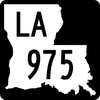
Louisiana Highway 975 (LA 975) is a gravel state highway in central Louisiana. It runs north–south for 18.4 miles (29.6 km). The southern terminus is at Whiskey Bay in Iberville Parish, and the northern terminus is east of Krotz Springs at a junction with U.S. Route 190 (US 190) and the north, south LA 973, in Pointe Coupee Parish. The entire route traverses the Sherburne Complex WMA, which is a combined Sherburne WMA, Atchafalaya National Wildlife Refuge, and Bayou Des Ourse, managed by the Louisiana Department of Wildlife and Fisheries. The road runs between the Atchafalaya River and Whiskey Bay Pilot Channel on the west and the East Protection Levee on the east.

The West Atchafalaya Floodway is a flood control structure of the Mississippi River and Tributaries Project located in the Lower Atchafalaya Basin in south-central Louisiana. It has a project design flood flow capacity of 250,000 cu ft/s (7,100 m3/s).
Atchafalaya is a ghost town that was located in St. Martin Parish, approximately 6 miles north of Butte La Rose, Louisiana, United States and just north of I-10 on the Atchafalaya River. The site of the town itself is located at coordinates 30°20'40.9"N 91°43'26.8"W, and is abandoned. United States Geological Survey maps from 1935 show the town to be located on the east bank of the Atchafalaya River at the Southern Pacific Railroad crossing, which was built in 1908. After the bridge was damaged due to the Great Mississippi Flood of 1927, the railroad from Lafayette to Baton Rouge was abandoned a few years later. With no transportation in and out, the town population began to dwindle, with the last resident leaving in 1959. There is no visible trace of the town left today.
Red Cross is a ghost town that was located in Pointe Coupee Parish's 1st Ward, approximately 12 miles west of Morganza, Louisiana, United States. The site of the town itself is located at coordinates 30°32'12.87"N, 91°44'24.59"W, at the intersection of the southern terminus of Louisiana Highway 417 and Louisiana Highway 10. The town is now abandoned. United States Geological Survey maps from 1948 show the town to be located on the east bank of the Atchafalaya River, directly across from Melville, Louisiana, slightly north of the railroad bridge.
References
- ↑ "Sherburne - Ghost Town". www.ghosttowns.com. Retrieved 2016-02-11.