New Idria, California

Last updated

New Idria
Idria
New Idria grounds.jpg
New Idria grounds, 2004
USA California location map.svg
Red pog.svg
New Idria
Location within the state of California
Usa edcp location map.svg
Red pog.svg
New Idria
New Idria (the United States)
Coordinates: 36°25′1″N120°40′28″W / 36.41694°N 120.67444°W / 36.41694; -120.67444 [1]
Country United States
State California
County San Benito County
Elevation
[1]
2,648 ft (807 m)
Time zone UTC−8 (Pacific)
  Summer (DST) UTC−7 (PDT)
ZIP codes
95027 (discontinued)
Area code 831
FIPS code06-36182
GNIS feature ID 1660786
Official nameNew Idria Mine [2]
Reference no.324

New Idria was an unincorporated town in San Benito County, California. It was named after the New Idria Mercury Mine, which closed in 1972, resulting in a ghost town.

Contents

Geography

The area is inside Area code 831. It is included in the Monterey Bay Unified Air Pollution Control District and the Panoche Elementary School District. [3] San Benito Mountain, elevation 5,241 feet (1,597 m), is located 3.6 miles (5.8 km) southeast. The nearest city is King City along U.S. Route 101.

The New Idria Mercury Mine was named in honor of the world's then second largest quicksilver mine in what was then Idria, Austria, now Idrija, Slovenia; (Slovene pronunciation [ĭdrija], California English pronunciation [īdria].) [4] The town grew to support the mining operations, but the mine closed in the 1970s. The town is currently an abandoned ghost town with more than 100 standing buildings, though vandalism has contributed to their deterioration in recent years. According to the US Geological Survey, both Idria (primary) and New Idria (variant) are recognized for federal use in describing the community. [1]

A part of a mercury extraction plant of the New Idria Quicksilver Mining Company New Idria fsa 8d35762.jpg
A part of a mercury extraction plant of the New Idria Quicksilver Mining Company

History

The community was established to support the mine, which mainly extracted mercury, since cinnabar was abundant in the local rock formations. Mercury mining at the location began in 1854. At one time, the New Idria mines were America's second most productive mines, with the New Almaden mines in the vicinity of San Jose, about 82 miles (132 km) northwest, being the first. [5]

The discovery of mercury ore at New Idria came soon after the discovery of gold in the Sierra foothills, which began the California gold rush. At that time, mercury was important in extracting gold from gold ore. Before the New Idria and New Almaden Quicksilver Mines, the mercury came almost exclusively from Europe. [5]

The New Idria Mining Company was formed soon after the discovery of cinnabar (quicksilver ore) in the southern Diablo Range of central California in 1854. The town of New Idria began around 1857 and about 300 men were employed at the mine by 1861. The first school opened in 1867 and the New Idria Post Office opened in 1869, with Edward A. Morse as the first postmaster. [6] In 1894, the New Idria Post Office dropped the word "New" and the town become known as Idria. [7] The New Idria Quicksilver Mining Company closed in 1972.

In an 1871 report to the United States House of Representatives, the surveyor general of California, Sherman Day, noted "...that the country about the mine is a series of rough and precipitous mountains and hills, intersected by deep canons; that the greater portion of it is barren and unsuited for agricultural purposes; it is essentially a minieral region..." [8]

On May 30, 1974, the town and surrounding 2,000 acres were auctioned by Wershow Auctioneers, in So. San Francisco. [9]

The town has since become a ghost town. [5]

The United States Postal Service operated a post office, going by the name Idria, with the ZIP Code 95027. The post office closed on January 2, 1974. [10]

New Idria is a California Historical Landmark (#324) [2] [5] and home of the world's first Gould Rotary Furnace, which revolutionized ore processing technology worldwide. [11]

On July 30, 2010, a fire destroyed 13 buildings on the north side of town. [12]

Superfund Site

In 2011, New Idria was re-listed as a U.S. Environmental Protection Agency (EPA) Superfund site, owing to unchecked mercury run-off and contamination. [13] As of June, 2012, the entire section of the former town site on the south side of New Idria/Clear Creek road is fenced-off.

Environmental concerns in the area

The New Idria Mercury Mine was initially investigated in the 1990s by the EPA, for possible inclusion on the EPA's National Priorities List, but the site did not rank high enough at that time to be listed. A site reassessment was begun in 2002, and an expanded site assessment begun in 2009, which was concluded in October 2010. [14] In March 2011, the EPA proposed New Idria to its National Priority List. [15] Elevated levels of mercury were found downstream of the town, as well as significant levels of mercury and other heavy metals found within tailings piles on the site. The region has a long history of mining, with asbestos and chromium being mined in addition to mercury; the EPA's 2004 Risk Assessment for the nearby Clear Creek Management Area identified 86 separate abandoned mines in the vicinity. [16] The natural rock formations in the area have been shedding asbestos-rich debris into stream valleys for millions of years [17] The average New Idria rock contains 5-15% by volume short fiber asbestos. [17] The 2010 edition of Rand McNally's The Road Atlas labels the area immediately south of New Idria as an "Asbestos Hazard Area".

A polluted stream near the mine New Idria Mercury Mine Polluted Water 2013.jpg
A polluted stream near the mine

Mineral collecting

The New Idria Mining District is known for its abundance of rare minerals such as benitoite, named after the San Benito River. Gem quality benitoite is only found in this area of the world. New Idria is also home to serpentinite rock. Many thousands of tectonic events acting on the serpentinite have produced extensive deposits of short-fiber asbestos. [17]

New-Idria-ghost-town-360-pano-b+w.jpg
360° in the center of the New Idria ghost town.

Climate

Climate data for Idria, California
MonthJanFebMarAprMayJunJulAugSepOctNovDecYear
Record high °F (°C)83
(28)
85
(29)
90
(32)
94
(34)
99
(37)
111
(44)
113
(45)
112
(44)
111
(44)
96
(36)
87
(31)
86
(30)
113
(45)
Mean daily maximum °F (°C)55.7
(13.2)
57.2
(14.0)
60.1
(15.6)
65.9
(18.8)
76.1
(24.5)
85.1
(29.5)
92.5
(33.6)
91.2
(32.9)
85.1
(29.5)
75.4
(24.1)
59.7
(15.4)
55.5
(13.1)
71.6
(22.0)
Mean daily minimum °F (°C)37.2
(2.9)
38.5
(3.6)
39.5
(4.2)
43.7
(6.5)
49.8
(9.9)
57.6
(14.2)
64.9
(18.3)
64.4
(18.0)
58.6
(14.8)
51.1
(10.6)
41.0
(5.0)
37.1
(2.8)
48.6
(9.2)
Record low °F (°C)14
(−10)
18
(−8)
18
(−8)
21
(−6)
30
(−1)
34
(1)
40
(4)
41
(5)
36
(2)
29
(−2)
21
(−6)
14
(−10)
14
(−10)
Average precipitation inches (mm)2.77
(70)
2.96
(75)
2.42
(61)
1.36
(35)
0.44
(11)
0.06
(1.5)
0.02
(0.51)
0.07
(1.8)
0.22
(5.6)
0.58
(15)
1.63
(41)
2.65
(67)
15.18
(384.41)
Average snowfall inches (cm)0.1
(0.25)
0.0
(0.0)
0.3
(0.76)
0.0
(0.0)
0.0
(0.0)
0.0
(0.0)
0.0
(0.0)
0.0
(0.0)
0.0
(0.0)
0.0
(0.0)
0.0
(0.0)
0.0
(0.0)
0.4
(1.01)
Source: WRCC [18]

See also

Related Research Articles

<span class="mw-page-title-main">Cinnabar</span> Red mercury(II) sulfide mineral, HgS

Cinnabar, or cinnabarite, also known as mercurblende is the bright scarlet to brick-red form of mercury(II) sulfide (HgS). It is the most common source ore for refining elemental mercury and is the historic source for the brilliant red or scarlet pigment termed vermilion and associated red mercury pigments.

<span class="mw-page-title-main">San Benito County, California</span> County in California, United States

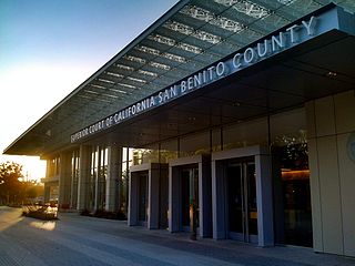
San Benito County, officially the County of San Benito, is a county located in the Coast Range Mountains of the U.S. state of California. As of the 2020 census, the population was 64,209. The county seat is Hollister.

<span class="mw-page-title-main">Almadén</span> Municipality in Castile-La Mancha, Spain

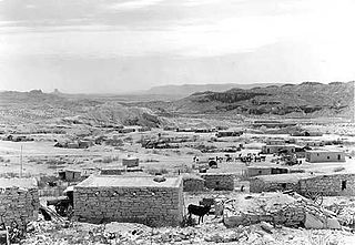
Almadén is a town and municipality in the spanish province of Ciudad Real, within the autonomous community of Castile-La Mancha. The town is located at 4° 49' W and 38° 46' N and is 589 meters above sea level. Almadén is approximately 300 km south of Madrid in the Sierra Morena. The name Almadén is from the Arabic: المعدن, romanized: al-maʻdin, lit. 'the metal', 'the mineral' or 'lode', and so by extension, the place where these are excavated, 'the mine'. Originally a Roman, and later, a Moorish mining settlement when taken from the Visigoths, the town was captured by the Christians in 1151 under king Alfonso VII and given to the Knights of the Order of Calatrava.

<span class="mw-page-title-main">Idrija</span> Place in Slovene Littoral, Slovenia

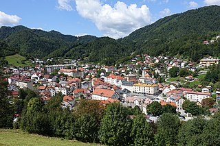
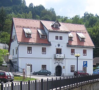
Idrija is a town in western Slovenia. It is the seat of the Municipality of Idrija. Located in the traditional region of the Slovene Littoral and in the Gorizia Statistical Region, it is notable for its mercury mine with stores and infrastructure, as well as miners' living quarters, and a miners' theatre. Together with the Spanish mine at Almadén, it has been a UNESCO World Heritage Site since 2012. In 2011, Idrija was given the Alpine Town of the Year award.

<span class="mw-page-title-main">Almaden Valley, San Jose</span> Neighborhood of San Jose, California, U.S.

Almaden Valley, commonly known simply as Almaden, is a valley and neighborhood of San Jose, California, located in South San Jose. It is nestled between the Santa Cruz Mountains to the west and the Santa Teresa Hills to the east, bordering the town of Los Gatos and West San Jose neighborhood.

<span class="mw-page-title-main">Almaden Quicksilver County Park</span> Former mercury mines adjacent to San Jose, California

Almaden Quicksilver County Park is a 4,163 acres (17 km2) park that includes the grounds of former mercury ("quicksilver") mines adjacent to south San Jose, California, USA. The park's elevation varies greatly: the most used entrances are less than 600 feet above sea level, while the highest point in the park is over 1,700 feet above sea level.

<span class="mw-page-title-main">Terlingua, Texas</span> Census-designated place in Texas, United States

Terlingua is a mining district and census-designated place (CDP) in southwestern Brewster County, Texas, United States. It is located near the Rio Grande and the villages of Lajitas and Study Butte, Texas, as well as the Mexican state of Chihuahua. The discovery of cinnabar, from which the metal mercury is extracted, in the mid-1880s brought miners to the area, creating a city of 2,000 people. The only remnants of the mining days are a ghost town of the Howard Perry-owned Chisos Mining Company and several nearby capped and abandoned mines: the California Hill, the Rainbow, the 248, and the Study Butte mines. The mineral terlinguaite was first found in the vicinity of California Hill.

<span class="mw-page-title-main">Diablo Range</span> Mountain range in the California Coastal Ranges

The Diablo Range is a mountain range in the California Coast Ranges subdivision of the Pacific Coast Ranges in northern California, United States. It stretches from the eastern San Francisco Bay Area at its northern end to the Salinas Valley area at its southern end.

<span class="mw-page-title-main">Sulphur Bank Mine</span> Mercury mine in California

The Sulphur Bank Mine is located near Clearlake Oaks and Clear Lake in Lake County, California. The 150-acre (0.61 km2) mine became one of the most noted mercury producers in the world.

<span class="mw-page-title-main">New Almaden</span> Neighborhood of San Jose in Santa Clara, California, United States

New Almaden, known in Spanish as Nueva Almadén, is a historic community and former mercury mine in the Capitancillos Hills of San Jose, California, located at the southwestern point of Almaden Valley in South San Jose. New Almaden is divided into two parts: the mines and much of their immediate surroundings, including historic ghost town settlements in the Capintancillas, which together form the Almaden Quicksilver County Park, and the largely residential historic district surrounding the Casa Grande.

<span class="mw-page-title-main">San Benito Mountain</span>

San Benito Mountain is the highest mountain in the Diablo Range of California. The summit is at an elevation of 5,267 feet (1,605 m). The rock is composed of asbestos (chrysotile), an ultramafic rock. It weathers to produce serpentine soils with characteristically low levels of nutrients like nitrogen, phosphorus, potassium, and calcium, and high levels of magnesium and heavy metals including nickel and chromium. This means little vegetation grows in the area though there are some plants that only grow on such soils like the local endemic San Benito evening primrose. The Clear Creek Management Area includes the San Benito Mountain Research Natural Area, recognized for its unique pine and incense cedar forest assemblage. The Mediterranean climate is punctuated by cool, wet winters and hot, dry summers.

<i>Camissonia benitensis</i> Species of flowering plant

Camissonia benitensis is a species of evening primrose known by the common names San Benito suncup and San Benito evening primrose. It is endemic to the Diablo Range of the South Coast Ranges of California, where its range includes far southern San Benito County, far western Fresno County, and far eastern Monterey County.

José de los Reyes Berreyesa, also spelled Berrelleza, was born at Mission Santa Clara de Asís in Las Californias province of the Spanish Viceroyalty of New Spain.

Clearcreekite is a carbonate mineral, polymorphous with peterbaylissite. The chemical formula of clearcreekite is Hg(1+)3CO3(OH)∙2H2O. It has a pale greenish yellow color and streak with tabular subhedral crystals and good cleavage on {001}. It is transparent with vitreous luster and uneven fracture. Its density (calculated from the idealized formula) is 6.96 g/cm3. The mineral is monoclinic with the space group P2/c. Clearcreekite is an extremely rare mineral from the Clear Creek mercury mine, New Idria district, San Benito County, California. It was probably formed after the alteration of other mercury minerals such as cinnabar. The mineral is named after the locality where it was found.

Almaden Mine can refer to:

<span class="mw-page-title-main">Mariscal Mine</span>

The Mariscal Mine, also known as the Lindsey Mine and the Ellis Mine, was a source of cinnabar ore that was refined at the Texas site into mercury. The mine is located in what is now Big Bend National Park. The mine produced a total of 1400 flasks of mercury, each weighing 76 pounds (34 kg), accounting for almost a quarter of the mercury production in the United States between 1900 and 1943.

<span class="mw-page-title-main">Heritage of Mercury. Almadén and Idrija</span> UNESCO World Heritage Site

Heritage of Mercury. Almadén and Idrija is a joint UNESCO World Heritage Site in Almadén, Castile-La Mancha, Spain, and Idrija, Slovenia. The property encompasses two mercury mining sites. In Almadén mercury has been extracted since Antiquity, while in Idrija it was first found in 1490.

The Atlas Asbestos Mine Superfund Site is located within the Clear Creek Management Area near Fresno County, eighteen miles northwest of Coalinga, California. The mine started operating in 1963, covering 435 acres of a large naturally occurring asbestos deposit. The mine closed in 1979 and was placed in the EPA's National Priorities List (NPL) in 1983 due to the pollution of asbestos in the surrounding soil, air and water creating potential health hazards for local populations and environment.

<span class="mw-page-title-main">New Idria Mercury Mine</span> Quicksilver Mine in California, United States

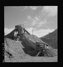
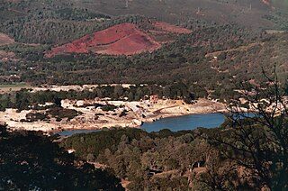
The New Idria Mercury Mine encompasses 8,000 acres of land in the Diablo Mountain range, incorporating the town of Idria in San Benito County, California. Idria, initially named New Idria, is situated at 36°25′01″N120°40′24″W and 2440 feet (680m) above mean sea level. The area was, in the past, recorded in the US Census Bureau as a rural community; however, Idria has become a ghost town since the closing of once lucrative mining operations in the early 1970s.

The Klau/Buena Vista Mine is a Superfund site located approximately 12 miles west of Paso Robles, San Luis Obispo County, California. It consists of two abandoned mercury mine sites that are located on adjacent properties on a northwest–southeast ridge of the Santa Lucia Range in the California coastal mountains. Mercury mining and ore processing operations occurred at these mines between 1868 and 1970.

References

  1. 1 2 3 "Idria". Geographic Names Information System . United States Geological Survey, United States Department of the Interior . Retrieved February 25, 2015.
  2. 1 2 "New Idria Mine". Office of Historic Preservation, California State Parks. Retrieved October 11, 2012.
  3. Area Code and school information was derived from US Department of Education files.
  4. "How do you pronounce Idria". Archived from the original on August 21, 2006. Retrieved September 24, 2006.{{cite web}}: CS1 maint: unfit URL (link)
  5. 1 2 3 4 "New Idria". Archived from the original on October 24, 2005. Retrieved July 28, 2005.{{cite web}}: CS1 maint: unfit URL (link)
  6. Salley, Harold E. (1991) History of California Post Offices, 1849-1990, p. 99. The Depot, ISBN   0-943645-27-1
  7. "The New Idria Time Line". Archived from the original on April 1, 2010. Retrieved December 2, 2009.{{cite web}}: CS1 maint: unfit URL (link)
  8. Peters. "H.Rept 41-24 - William McGarrahan. February 1, 1871. -- Recommitted to the Committee on the Judiciary and ordered to be printed". GovInfo.gov. U.S. Government Printing Office. Retrieved June 17, 2023.
  9. "Advertisement". The Fresno Bee. May 12, 1974. pp. B9.
  10. "United States Postal Bulletin, Vol. 95, Issue 20973" (PDF). United States Postal Service. March 14, 1974. p. 6.
  11. "Gould Rotary Furnace". Archived from the original on September 26, 2007. Retrieved May 6, 2007.{{cite web}}: CS1 maint: unfit URL (link)
  12. "Fire destroys 13 buildings in abandoned New Idria - Gilroy Dispatch: Crime Fire Courts". www.gilroydispatch.com. Archived from the original on January 24, 2013. Retrieved February 5, 2022.
  13. Historic 'New Idria' listed as Superfund site, Thursday, September 15, 2011, KGO TV, San Francisco
  14. "New Idria superfund status at U.S. EPA". Cfpub.epa.gov.
  15. "EPA – New Idria Mercury Mine". Epa.gov. January 29, 2013.
  16. "Search for Superfund Sites Where You Live". Epa.gov. September 4, 2015.
  17. 1 2 3 Ross, M (2003). "History of asbestos discovery and use and asbestos related disease in context with the occurrence of asbestos within ophiolite complexes." Geological Society of America, special paper 373
  18. "Period of Record Monthly Climate Summary". Western Regional Climate Center. Retrieved September 17, 2022.