Related Research Articles
San Joaquin County, officially the County of San Joaquin, is a county located in the U.S. state of California. As of the 2020 census, the population was 779,233. The county seat is Stockton.

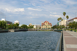
Lodi is a city located in San Joaquin County, California, United States, in the center portion of California's Central Valley. The population was 66,348 at the 2020 census.
California's 9th congressional district is a congressional district in the U.S. state of California. Josh Harder, a Democrat, has represented the district since January 2023.

Area codes 209 and 350 are telephone area codes in the North American Numbering Plan (NANP) for the U.S. state of California. Their service area includes Stockton, Modesto, Turlock, Merced, Winton, Atwater, Livingston, Manteca, Ripon, Tracy, Lodi, Galt, Sonora, Los Banos, San Andreas, Mariposa, and Yosemite, the northern San Joaquin Valley, and the Sierra Foothills.

The San Joaquin County Historical Society and Museum is located at Micke Grove Regional Park, between Lodi, California and Stockton, California. It was established in 1966 by San Joaquin County and the San Joaquin County Historical Society.
Acampo is a small census-designated place (CDP) just north of Lodi in San Joaquin County, California, United States. In the 1870s, Acampo was named as a Southern Pacific Railroad station. Acampo's population was 341 at the 2010 census.
The Jahant AVA is an American Viticultural Area located within the Lodi AVA. Most of the AVA is located within San Joaquin County, California, with a small part in Sacramento County. At 28,000 acres (11,331 ha), Jahant is the smallest of the Lodi sub-appellations. The area is known for its distinctive pink colored Rocklin-Jahant loam soil with the AVA's boundaries being delineated by the extent and reaches of the soil. This low-lying AVA is affected by its close proximity to the Mokelumne River and the Sacramento-San Joaquin River Delta which keeps the climate cool and dry.
The Borden Ranch AVA is an American Viticultural Area located in both Sacramento County and San Joaquin County, California. It is part of the larger Lodi AVA. Located in the east central portion of the Lodi area, Borden Ranch vineyards are located at altitudes between 73 feet (22 m) and 520 feet (158 m) above sea level. The northern edge of the AVA is defined by Laguna Creek and the southern edge is defined by Dry Creek, both of which flow out of the foothills of the Sierra Nevada Mountains into the San Joaquin Valley. The soils in Borden Ranch is alluvial with cobbles, clay pan, and clay loam. Red wine grape varietals are the most commercially important grapes in the area.

The Mokelumne River AVA is an American Viticultural Area located in San Joaquin County, California. It is located in the southwest part of the larger Lodi AVA, and includes the city of Lodi and the towns of Woodbridge and Acampo. The AVA is named after the Mokelumne River, which drains out of the Sierra Nevada Mountains into the San Joaquin River and passes through the heart of the appellation. The wine region includes a portion of the lower Mokelumne River and the Cosumnes River, a tributary. The Mokelumne River AVA covers 87,500 acres (35,410 ha), of which 42,000 acres (16,997 ha) are planted to wine grapes. The soil in the area is alluvial fan deposits of sand and loam. Ample rainfall and soil moisture retention allows most grape growers to farm without the use of irrigation.
The Clements Hills AVA is an American Viticultural Area located in San Joaquin County, California. It is located in the southeast part of the larger Lodi AVA. The Mokelumne River flows through the wine region, which is composed of rolling hills between 90 feet (27 m) and 400 feet (122 m) in elevation. A variety of microclimates exist within the hills of the region. The soils in the area includes loams, clay loams, and clays. Below the alluvial top soil are areas of granite and volcanic soils.
The Lodi News-Sentinel is a daily newspaper based in Lodi, California, United States, and serving northern San Joaquin and southern Sacramento counties.
Burson is an unincorporated community in Calaveras County, California. It lies at an elevation of 98 feet. Although unincorporated, Burson has the ZIP code of 95225.
Clements is an unincorporated community in San Joaquin County, California, United States. Clements is located on California State Route 12 and California State Route 88, 11 miles (18 km) east-northeast of Lodi. Clements has a post office with ZIP code 95227.
Thornton is a census-designated place (CDP) in San Joaquin County, California, United States. Thornton is located along Interstate 5 7 miles (11 km) west-southwest of Galt. Thornton has a post office with ZIP code 95686.
Rancho Sanjon de los Moquelumnes was a 35,508-acre (143.70 km2) Mexican land grant in present-day Sacramento County and San Joaquin County, California given in 1844 by Governor Manuel Micheltorena to Anastasio Chaboya. Sanjon is Spanish for ditch or deep slough. The grant stretched from the Cosumnes River on the north to the Mokelumne River on the south, and encompassed present-day Galt.
Mokelumne City is a ghost town in San Joaquin County, California, United States. Mokelumne, established in 1850, was the second largest town in San Joaquin County until it was destroyed by the floods of 1862.

San Joaquin City is a former settlement in San Joaquin County, California. It was established in 1849, during the California Gold Rush. It was located on the west bank of the San Joaquin River just below the point where Airport Way crosses the river today. It was an important settlement along the old River Road between Banta and Grayson's Ferry (now the community of Grayson in Stanislaus County.
Elliott is a ghost town in San Joaquin County, in the U.S. state of California.

Ward Island is a small island in the Sacramento–San Joaquin River Delta. It is part of San Joaquin County, California. Its coordinates are 38°02′30″N121°30′09″W, and the United States Geological Survey measured its elevation as 7 ft (2.1 m) in 1981. It appears on a 1952 USGS map of the area.

The Atlas Tract is an island in the Sacramento–San Joaquin River Delta, in San Joaquin County, California. It has been used for agriculture since it was first reclaimed in the late 19th century.
References
- 1 2 "Older towns dot valley when Lodi established". Lodi News-Sentinel. Sep 9, 1969. pp. 8C. Retrieved 28 October 2015.
- ↑ "San Joaquin County". Jim Forte Postal History. Retrieved 28 October 2015.
Municipalities and communities of San Joaquin County, California, United States | ||
|---|---|---|
| Cities |  | |
| Census-designated places | ||
| Unincorporated communities | ||
| Ghost towns | ||
38°14′25″N121°17′24″W / 38.2402°N 121.2900°W
| | This San Joaquin County, California–related article is a stub. You can help Wikipedia by expanding it. |