Linden, California

Last updated
Linden
Linden, California 2.jpg
San Joaquin County California Incorporated and Unincorporated areas Linden Highlighted.svg
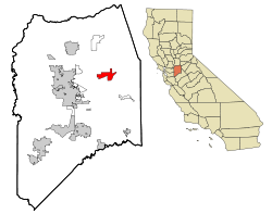
Location in San Joaquin County and the state of California
Usa edcp location map.svg
Red pog.svg
Linden
Location in the United States
Coordinates: 38°1′12″N121°5′29″W / 38.02000°N 121.09139°W / 38.02000; -121.09139 Coordinates: 38°1′12″N121°5′29″W / 38.02000°N 121.09139°W / 38.02000; -121.09139
Country Flag of the United States.svg  United States
State Flag of California.svg  California
County San Joaquin
Government
   State senator Susan Eggman (D) [1]
   Assemblymember Heath Flora (R) [1]
   U. S. rep. Jerry McNerney (D) [2]
Area
[3]
  Total7.461 sq mi (19.324 km2)
  Land7.409 sq mi (19.189 km2)
  Water0.052 sq mi (0.135 km2)  0.70%
Elevation
[4]
92 ft (28 m)
Population
 (2010)
  Total1,784
  Density240/sq mi (92/km2)
Time zone UTC-8 (Pacific Time Zone)
  Summer (DST) UTC-7 (PDT)
ZIP code
95236
Area code 209
FIPS code 06-41670
GNIS feature ID 277540

Linden is a census-designated place (CDP) in San Joaquin County, California, United States. The population was 1,784 at the 2010 census, up from 1,103 at the 2000 census. The city is host of the Linden Cherry Festival each spring.

Contents

Geography

Linden is located at 38°1′12″N121°5′29″W / 38.02000°N 121.09139°W / 38.02000; -121.09139 (38.019989, -121.091450), [5] along California Highway 26 and is approx 13 miles ENE of Stockton.

According to the United States Census Bureau, the CDP has a total area of 7.5 square miles (19 km2), 99.30% of it land and 0.70% of it water.

Demographics

Historical population
CensusPop.
U.S. Decennial Census [6]

2010

At the 2010 census Linden had a population of 1,784. The population density was 239.1 inhabitants per square mile (92.3/km2). The racial makeup of Linden was 1,541 (86.4%) White, 6 (0.3%) African American, 10 (0.6%) Native American, 25 (1.4%) Asian, 1 (0.1%) Pacific Islander, 127 (7.1%) from other races, and 74 (4.1%) from two or more races. Hispanic or Latino of any race were 385 people (21.6%). [7]

The census reported that 1,784 people (100% of the population) lived in households, no one lived in non-institutionalized group quarters and no one was institutionalized.

There were 631 households, 275 (43.6%) had children under the age of 18 living in them, 389 (61.6%) were opposite-sex married couples living together, 76 (12.0%) had a female householder with no husband present, 36 (5.7%) had a male householder with no wife present. There were 32 (5.1%) unmarried opposite-sex partnerships, and 4 (0.6%) same-sex married couples or partnerships. 106 households (16.8%) were one person and 41 (6.5%) had someone living alone who was 65 or older. The average household size was 2.83. There were 501 families (79.4% of households); the average family size was 3.18.

The age distribution was 516 people (28.9%) under the age of 18, 118 people (6.6%) aged 18 to 24, 468 people (26.2%) aged 25 to 44, 461 people (25.8%) aged 45 to 64, and 221 people (12.4%) who were 65 or older. The median age was 36.9 years. For every 100 females, there were 98.2 males. For every 100 women age 18 and over, there were 99.4 men.

There were 673 housing units at an average density of 90.2 per square mile, of the occupied units 490 (77.7%) were owner-occupied and 141 (22.3%) were rented. The homeowner vacancy rate was 2.0%; the rental vacancy rate was 6.0%. 1,339 people (75.1% of the population) lived in owner-occupied housing units and 445 people (24.9%) lived in rental housing units.

2000

At the 2000 census there were 1,103 people, 384 households, and 316 families in the CDP. The population density was 146.8 inhabitants per square mile (56.7/km2). There were 400 housing units at an average density of 53.3 per square mile (20.6/km2). The racial makeup of the CDP was 88.03% White, 0.27% African American, 1.63% Native American, 0.82% Asian, 5.62% from other races, and 3.63% from two or more races. Hispanic or Latino of any race were 14.05%. [8]

Of the 384 households 42.4% had children under the age of 18 living with them, 68.8% were married couples living together, 9.9% had a female householder with no husband present, and 17.7% were non-families. Of all households 15.4% were one person and 8.1% were one person aged 65 or older. The average household size was 2.87 and the average family size was 3.21.

The age distribution was 30.8% under the age of 18, 6.8% from 18 to 24, 25.7% from 25 to 44, 25.0% from 45 to 64, and 11.6% 65 or older. The median age was 38 years. For every 100 females, there were 100.5 males. For every 100 females age 18 and over, there were 95.1 males.

The median household income was $51,250 and the median family income was $57,813. Males had a median income of $56,164 versus $39,750 for females. The per capita income for the CDP was $21,094. About 9.5% of families and 7.1% of the population were below the poverty line, including 8.5% of those under age 18 and 16.7% of those age 65 or over.

Notable people and events

The 1974 film Dirty Mary, Crazy Larry was filmed in and around Linden. [9]

Pavement, a band hailing from nearby Stockton, immortalizes the town in "Feed 'Em to the (Linden) Lions", song three on their 1992 EP, Watery, Domestic .

The Speed Freak Killers, a serial killer duo, are from Linden. [10]

Ervin Zádor, gold medalist at 1956 Summer Olympics in water polo and famous for being brutally punched in the Blood in the Water match, spent the last years of his life in Linden. [11]

Aaron Judge, a professional baseball player and the 2017 AL Rookie of the Year and 2022 AL Most Valuable Player, is from Linden. [12]

Related Research Articles

<span class="mw-page-title-main">Meadow Vista, California</span> Census-designated place in California, United States

Meadow Vista is a census-designated place (CDP) in Placer County, California, United States. It is part of the Sacramento–Arden-Arcade–Roseville Metropolitan Statistical Area. The population was 3,217 at the 2010 census, up from 3,096 at the 2000 census.

<span class="mw-page-title-main">North Auburn, California</span> Census-designated place in California, United States

North Auburn is a census-designated place (CDP) in Placer County, California, United States. It is part of the Sacramento–Arden-Arcade–Roseville Metropolitan Statistical Area. The population was 13,452 at the 2020 census.

<span class="mw-page-title-main">East Shore, California</span> Census-designated place in California, United States

East Shore is a census-designated place (CDP) in Plumas County, California, United States. The population was 156 at the 2010 census, down from 177 at the 2000 census.

<span class="mw-page-title-main">Hamilton Branch, California</span> Census-designated place in California, United States

Hamilton Branch is a census-designated place (CDP) in Plumas County, California, United States. The population was 587 at the 2000 census.

<span class="mw-page-title-main">Lake Almanor Country Club, California</span> Census-designated place in California, United States

Lake Almanor Country Club is a census-designated place (CDP) in Plumas County, California, United States. The population was 419 at the 2010 census, down from 847 at the 2000 census. The ZIP code for the CDP is 96137.

<span class="mw-page-title-main">Lake Almanor Peninsula, California</span> Census-designated place in California, United States

Lake Almanor Peninsula is a census-designated place (CDP) in Plumas County, California, United States. The population was 356 at the 2010 census, up from 336 at the 2000 census.

<span class="mw-page-title-main">Lake Almanor West, California</span> Census-designated place in California, United States

Lake Almanor West is a census-designated place (CDP) in Plumas County, California, United States. The population was 270 at the 2010 census, down from 329 at the 2000 census.

<span class="mw-page-title-main">Prattville, California</span> Census-designated place in California, United States

Prattville is a census-designated place (CDP) in Plumas County, California, United States. The population was 33 at the 2010 census, up from 28 at the 2000 census.

<span class="mw-page-title-main">Tobin, California</span> Census-designated place in California, United States

Tobin is a census-designated place (CDP) in Plumas County, California, United States. The population was 12 at the 2010 census, up from 11 at the 2000 census.

<span class="mw-page-title-main">Foothill Farms, California</span> Census-designated place in California, United States

Foothill Farms is a census-designated place (CDP) and unincorporated community in Sacramento County, California, USA. It is part of the Sacramento–Arden-Arcade–Roseville Metropolitan Statistical Area. The population was 33,121 at the 2010 census, up from 17,426 at the 2000 census. Foothill Farms is part of the greater North Highlands-Foothill Farms community, and comprises the zip codes 95841 and 95842. Susan Ual services as President of the New Foothill Farms Community Association while Michael Baker services as the President of the Old Foothill Farms Community Association

www.oldfoothillfarms.org
<span class="mw-page-title-main">Garden Acres, California</span> Census-designated place in California, United States

Garden Acres is a census-designated place (CDP) in San Joaquin County, California, United States. The population was 10,648 at the 2010 census, up from 9,747 at the 2000 census. It is the most populous CDP in San Joaquin County.

<span class="mw-page-title-main">Kennedy, California</span> Census-designated place in California, United States

Kennedy is a census-designated place (CDP) in San Joaquin County, California, United States. The population was 3,356, at the 2020 census, up from 3,254 at the 2000 census.

<span class="mw-page-title-main">Morada, California</span> Census-designated place in California, United States

Morada is a census-designated place (CDP) in San Joaquin County, California, United States. The population was 3,166 at the 2020 census, down from 3,828 at the 2010 census.

<span class="mw-page-title-main">East Foothills, San Jose</span> Census designated place in California, United States

East Foothills is a census-designated place (CDP) in Santa Clara County, California, United States and a neighborhood of San Jose. The population was 8,269 at the 2010 census and it is located about 4 miles east of downtown San Jose.

<span class="mw-page-title-main">Fruitdale, San Jose</span> Place in California, United States

Fruitdale is a district of San Jose, California, located in West San Jose, though some portions are still unincorporated as a census-designated place. The population of the CDP was 935 at the 2010 census.

<span class="mw-page-title-main">Amesti, California</span> Census-designated place in California, United States

Amesti is a census-designated place (CDP) in Santa Cruz County, California, United States. The population was 2,637 as of the 2020 United States census.

<span class="mw-page-title-main">Corralitos, California</span> Census-designated place in California, United States

Corralitos is a census-designated place (CDP) in Santa Cruz County, California, United States. It is a rural area known for its agriculture of apples and strawberries, and its notable Corralitos Market and Sausage Co. Moreover, its location near the Pacific Ocean optimizes viticulture.

<span class="mw-page-title-main">Lakeside, Montana</span> Unincorporated community in Montana, United States

Lakeside is an unincorporated area and census-designated place (CDP) in Flathead County, Montana, United States. The population was 2,669 at the 2010 census, up from 1,679 in 2000.

<span class="mw-page-title-main">Challenge–Brownsville, California</span> Census-designated place in California, United States

Challenge–Brownsville is a census-designated place (CDP) in Yuba County, California, United States. The population was 1,148 at the 2010 census, up from 1,069 at the 2000 census.

<span class="mw-page-title-main">Indian Hills, Nevada</span> Census-designated place in Nevada, United States

Indian Hills is a census-designated place (CDP) in Douglas County, Nevada, United States. It lies on the south side of the Carson City metropolitan area. The population was 5,627 at the 2010 census.

References

  1. 1 2 "Statewide Database". UC Regents. Archived from the original on February 1, 2015. Retrieved January 30, 2015.
  2. "California's 9th Congressional District - Representatives & District Map". Civic Impulse, LLC. Retrieved March 12, 2013.
  3. "2010 Census U.S. Gazetteer Files – Places – California". United States Census Bureau.
  4. "Linden". Geographic Names Information System . United States Geological Survey, United States Department of the Interior . Retrieved February 10, 2015.
  5. "US Gazetteer files: 2010, 2000, and 1990". United States Census Bureau. 2011-02-12. Retrieved 2011-04-23.
  6. "Census of Population and Housing". Census.gov. Retrieved June 4, 2016.
  7. "2010 Census Interactive Population Search: CA - Linden CDP". U.S. Census Bureau. Archived from the original on July 15, 2014. Retrieved July 12, 2014.
  8. "U.S. Census website". United States Census Bureau . Retrieved 2008-01-31.
  9. Movies Divorce, Disillusion......hard times hit the easy rider Shevey, Sandra. Chicago Tribune 17 Feb 1974: e14.
  10. "Speed Freak Killers cast spotlight on small town Linden". The Mercury News. February 18, 2012. Retrieved January 30, 2021.
  11. Cortez, Joe (August 5, 2017). "A rebel to the Soviets, a hero in Hungary, now his children bring his ashes home". The Modesto Bee. Retrieved January 29, 2021.
  12. Ken Davidoff; George A. King III (June 15, 2017). "What Aaron Judge means to his hometown". New York Post. Retrieved October 27, 2017.