August, California

Last updated
August
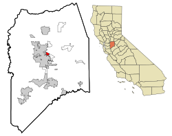
San Joaquin County California Incorporated and Unincorporated areas August Highlighted.svg
Location in San Joaquin County and the state of California
Usa edcp location map.svg
Red pog.svg
August
Location in the United States
Coordinates: 37°58′48″N121°15′50″W / 37.98000°N 121.26389°W / 37.98000; -121.26389 Coordinates: 37°58′48″N121°15′50″W / 37.98000°N 121.26389°W / 37.98000; -121.26389
Country Flag of the United States.svg  United States
State Flag of California.svg  California
County San Joaquin
Government
   State Senator Susan Eggman (D) [1]
   Assemblymember Carlos Villapudua (D) [1]
   U. S. Rep. Jerry McNerney (D) [2]
Area
[3]
  Total1.26 sq mi (3.25 km2)
  Land1.26 sq mi (3.25 km2)
  Water0.00 sq mi (0.00 km2)  0%
Elevation
[4]
26 ft (8 m)
Population
 (2020)
  Total8,628
  Density6,869.43/sq mi (2,652.67/km2)
Time zone UTC-8 (PST)
  Summer (DST) UTC-7 (PDT)
ZIP code
95231
Area code 209
FIPS code 06-03209
GNIS feature ID 1866996

August is a census-designated place (CDP) in San Joaquin County, California, United States. The population was 8,628 at the 2020 census, up from 8,390 at the 2010 census.

Contents

Geography

August is located at 37°58′48″N121°15′50″W / 37.98000°N 121.26389°W / 37.98000; -121.26389 (37.979890, -121.263984). [5]

According to the United States Census Bureau, the CDP has a total area of 1.3 square miles (3.4 km2), all of it land.

Demographics

Historical population
CensusPop.
1970 6,735
1980 5,445−19.2%
1990 6,37617.1%
2000 7,80822.5%
2010 8,3907.5%
2020 8,6282.8%
source: [6]

2010

At the 2010 census August had a population of 8,390. The population density was 6,705.8 inhabitants per square mile (2,589.1/km2). The racial makeup of August was 3,914 (46.7%) White, 224 (2.7%) African American, 183 (2.2%) Native American, 358 (4.3%) Asian, 20 (0.2%) Pacific Islander, 3,110 (37.1%) from other races, and 581 (6.9%) from two or more races. Hispanic or Latino of any race were 5,897 persons (70.3%). [7]

The census reported that 8,287 people (98.8% of the population) lived in households, 10 (0.1%) lived in non-institutionalized group quarters, and 93 (1.1%) were institutionalized.

There were 2,298 households, 1,234 (53.7%) had children under the age of 18 living in them, 1,040 (45.3%) were opposite-sex married couples living together, 485 (21.1%) had a female householder with no husband present, 249 (10.8%) had a male householder with no wife present. There were 234 (10.2%) unmarried opposite-sex partnerships, and 28 (1.2%) same-sex married couples or partnerships. 391 households (17.0%) were one person and 134 (5.8%) had someone living alone who was 65 or older. The average household size was 3.61. There were 1,774 families (77.2% of households); the average family size was 4.01.

The age distribution was 2,852 people (34.0%) under the age of 18, 957 people (11.4%) aged 18 to 24, 2,385 people (28.4%) aged 25 to 44, 1,605 people (19.1%) aged 45 to 64, and 591 people (7.0%) who were 65 or older. The median age was 28.0 years. For every 100 females, there were 107.1 males. For every 100 females age 18 and over, there were 107.6 males.

There were 2,560 housing units at an average density of 2,046.1 per square mile, of the occupied units 1,148 (50.0%) were owner-occupied and 1,150 (50.0%) were rented. The homeowner vacancy rate was 3.6%; the rental vacancy rate was 10.7%. 3,966 people (47.3% of the population) lived in owner-occupied housing units and 4,321 people (51.5%) lived in rental housing units.
2000

At the 2000 census there were 7,808 people, 2,412 households, and 1,736 families in the CDP. The population density was 6,034.9 inhabitants per square mile (2,330.1/km2). There were 2,614 housing units at an average density of 2,020.4 per square mile (780.1/km2). The racial makeup of the CDP was 51.33% White, 1.32% African American, 3.04% Native American, 3.24% Asian, 0.54% Pacific Islander, 34.13% from other races, and 6.40% from two or more races. Hispanic or Latino of any race were 55.97%. [8]

Of the 2,412 households 41.0% had children under the age of 18 living with them, 45.1% were married couples living together, 18.2% had a female householder with no husband present, and 28.0% were non-families. 21.6% of households were one person and 9.2% were one person aged 65 or older. The average household size was 3.23 and the average family size was 3.78.

The age distribution was 33.4% under the age of 18, 11.2% from 18 to 24, 29.6% from 25 to 44, 16.7% from 45 to 64, and 9.1% 65 or older. The median age was 29 years. For every 100 females, there were 104.6 males. For every 100 females age 18 and over, there were 103.2 males.

The median household income was $25,222 and the median family income was $26,676. Males had a median income of $25,922 versus $20,317 for females. The per capita income for the CDP was $11,037. About 28.0% of families and 29.8% of the population were below the poverty line, including 34.9% of those under age 18 and 11.3% of those age 65 or over.

Related Research Articles

North Auburn, California Census-designated place in California, United States

North Auburn is a census-designated place (CDP) in Placer County, California, United States. It is part of the Sacramento–Arden-Arcade–Roseville Metropolitan Statistical Area. The population was 13,022 at the 2010 census, up from 11,847 at the 2000 census.

East Shore, California Census-designated place in California, United States

East Shore is a census-designated place (CDP) in Plumas County, California, United States. The population was 156 at the 2010 census, down from 177 at the 2000 census.

Hamilton Branch, California Census-designated place in California, United States

Hamilton Branch is a census-designated place (CDP) in Plumas County, California, United States. The population was 587 at the 2000 census.

Indian Falls, California Census-designated place in California, United States

Indian Falls is a census-designated place (CDP) in Plumas County, California, United States. The population was 54 at the 2010 census, up from 37 at the 2000 census.

Lake Almanor Country Club, California Census-designated place in California, United States

Lake Almanor Country Club is a census-designated place (CDP) in Plumas County, California, United States. The population was 419 at the 2010 census, down from 847 at the 2000 census. The ZIP code for the CDP is 96137.

Lake Almanor Peninsula, California Census-designated place in California, United States

Lake Almanor Peninsula is a census-designated place (CDP) in Plumas County, California, United States. The population was 356 at the 2010 census, up from 336 at the 2000 census.

Lake Almanor West, California Census-designated place in California, United States

Lake Almanor West is a census-designated place (CDP) in Plumas County, California, United States. The population was 270 at the 2010 census, down from 329 at the 2000 census.

Prattville, California Census-designated place in California, United States

Prattville is a census-designated place (CDP) in Plumas County, California, United States. The population was 33 at the 2010 census, up from 28 at the 2000 census.

Tobin, California Census-designated place in California, United States

Tobin is a census-designated place (CDP) in Plumas County, California, United States. The population was 12 at the 2010 census, up from 11 at the 2000 census.

Kennedy, California Census-designated place in California, United States

Kennedy is a census-designated place (CDP) in San Joaquin County, California, United States. The population was 3,356, at the 2020 census, up from 3,254 at the 2000 census.

Morada, California Census-designated place in California, United States

Morada is a census-designated place (CDP) in San Joaquin County, California, United States. The population was 3,166 at the 2020 census, down from 3,828 at the 2010 census.

Taft Mosswood, California Census-designated place in California, United States

Taft Mosswood is a census-designated place (CDP) in San Joaquin County, California, United States. The population was 1,530 at the 2010 census, up from 1,388 at the 2000 census. It comprises an unincorporated "island" within the City of Stockton.

East Foothills, San Jose Census designated place in California, United States

East Foothills is a census-designated place (CDP) in Santa Clara County, California, United States and a neighborhood of San Jose. The population was 8,269 at the 2010 census and it is located about 4 miles east of downtown San Jose.

Fruitdale, San Jose Place in California, United States

Fruitdale is a district of San Jose, California, located in West San Jose, though some portions are still unincorporated as a census-designated place. The population of the CDP was 935 at the 2010 census.

Corralitos, California Census-designated place in California, United States

Corralitos is a census-designated place (CDP) in Santa Cruz County, California, United States. It is a rural area known for its agriculture of apples and strawberries, and its notable Corralitos Market and Sausage Co. Moreover, its location near the Pacific Ocean optimizes viticulture.

Freedom, California Census-designated place in California, United States

Freedom is a census-designated place (CDP) in Santa Cruz County, California, United States. The population was 3,070 at the 2010 census.

Oak Grove, South Carolina Census-designated place in South Carolina, United States

Oak Grove is a census-designated place (CDP) in Lexington County, South Carolina, United States. The population was 10,291 at the 2010 census. It is part of the Columbia Metropolitan Statistical Area.

Canyon Creek, Washington CDP in Washington, United States

Canyon Creek is a census-designated place (CDP) in Snohomish County, Washington, United States. The population was 3,200 at the 2010 census. Prior to the 2010 census, the CDP was known as Jordan Road-Canyon Creek.

Union Center, Wisconsin Village in Wisconsin, United States

Union Center is a village in Juneau County, Wisconsin, United States, along the Baraboo River. The population was 200 at the 2010 census.

Hawk Springs, Wyoming CDP in Wyoming, United States

Hawk Springs is a census-designated place (CDP) in Goshen County, Wyoming, United States. The population was 45 at the 2010 census.

References

  1. 1 2 "Statewide Database". UC Regents. Archived from the original on February 1, 2015. Retrieved December 10, 2014.
  2. "California's 9th Congressional District - Representatives & District Map". Civic Impulse, LLC. Retrieved October 7, 2014.
  3. "2020 U.S. Gazetteer Files". United States Census Bureau. Retrieved October 30, 2021.
  4. "August". Geographic Names Information System . United States Geological Survey . Retrieved December 29, 2014.
  5. "US Gazetteer files: 2010, 2000, and 1990". United States Census Bureau. 2011-02-12. Retrieved 2011-04-23.
  6. "CENSUS OF POPULATION AND HOUSING (1790–2000)". U.S. Census Bureau . Retrieved 2021-04-24.
  7. "2010 Census Interactive Population Search: CA - August CDP". U.S. Census Bureau. Archived from the original on December 28, 2016. Retrieved July 12, 2014.
  8. "U.S. Census website". United States Census Bureau . Retrieved 2008-01-31.