
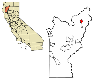
Caribou is a census-designated place located in Plumas County, California, United States. As of the 2010 Census, the town had a population of 0, however, as of 2020, the population had risen to 1. Caribou is located on the North Fork Feather River, 9.5 miles (15.3 km) south of Almanor. The closest communities are Belden to the southwest, Twain to the southeast, Canyondam to the north, and Greenville to the east.

Weitchpec is an unincorporated village and CDP within the Yurok reservation in Humboldt County, California, United States. It is located 35 miles (56 km) northeast of Eureka, at an elevation of 361 feet. The ZIP Code is 95546.
Brooks is an unincorporated community and census-designated place (CDP) in Yolo County, California, located in the Capay Valley in the northwest of the county. Brooks' ZIP Code is 95606 and its area code 530. The Yocha Dehe Wintun Nation is headquartered in Brooks. The town is home to a large casino Cache Creek Casino Resort. It lies at an elevation of 341 feet.
Trinity Center is a census-designated place (CDP) in Trinity County, California, United States. Trinity Center is located 29 miles (47 km) north of Weaverville. It is home to Trinity Lake, a popular summer tourist destination. It is home to a store, Trinity Center Airport, a marina, a community church, several campgrounds, and several small resorts.
Salyer is an unincorporated community and census-designated place (CDP) in Trinity County, California. Salyer is located on State Highway 299, 52 miles (84 km) east of Eureka and 93 miles (150 km) west of Redding. Its population is 389 as of the 2020 census. For statistical purposes, the United States Census Bureau has defined Salyer as a census-designated place (CDP). The census definition of the area may not precisely correspond to local understanding of the area with the same name.
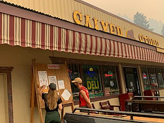
Coffee Creek is a census-designated place located within Trinity County in the U.S. state of California. It is located just north of where Coffee Creek flows into the Trinity River along Highway 3 and is the most northern community in Trinity County. It contains the Coffee Creek elementary school. Coffee Creek Road originates at Highway 3 offering access to the interior of the Trinity Alps; the road is 20 miles long, dirt and only for high clearance vehicles. Coffee Creek sits at an elevation of 2,495 feet (760 m). Its population is 152 as of the 2020 census, down from 217 from the 2010 census.

Castella is a small, unincorporated community and census-designated place (CDP) in the upper Sacramento Canyon of Shasta County, California. It is located 46 miles north of Redding on Interstate 5, and is home to Castle Crags State Park. Its population is 214 as of the 2020 census. It has a Chevron gas station/store and a post office. The ZIP Code is 96017. The community is inside area code 530.

Edison is an unincorporated community and census designated place (CDP) in the Tehachapi mountains of Kern County, California. It is located 7.5 miles (12 km) east-southeast of downtown Bakersfield, at an elevation of 571 feet (174 m).
Alta Sierra is an unincorporated community and census-designated place (CDP) in Kern County, California.

Old River is an unincorporated community and census-designated place (CDP) in Kern County, California. It is located 9.5 miles (15 km) southwest of Bakersfield, at an elevation of 341 feet (104 m).
Sugarloaf Mountain Park is a former census-designated place (CDP) in Tulare County, California. Sugarloaf Mountain Park sits at an elevation of 5,991 feet (1,826 m). The CDP was first listed in the 2010 U.S. Census although with zero population. The CDP was deleted prior to the 2020 U.S. Census.
Sage is an unincorporated community and census-designated place (CDP) in Riverside County, California, United States. It has a population of 3,370 according to the 2020 census. Its elevation is 2,313 feet (705 m).
Millerton is an unincorporated community and census-designated place (CDP) in Fresno County, California, United States. It is located 3 miles (5 km) east of Friant and 23 miles (37 km) north-northeast of Fresno.
Canon City, California is a ghost town in Trinity County, California.
Wautec is an unincorporated community and census-designated place (CDP) in Humboldt County, California, United States. It is located within the Yurok Indian Reservation, in the valley of the Klamath River 20 miles (32 km) northeast (downstream) of Weitchpec.
Cedar Flat is a census-designated place (CDP) in eastern Placer County, California, United States. It is located on the northwest shore of Lake Tahoe, between Carnelian Bay to the northeast and Dollar Point to the southwest. It was first listed as a CDP prior to the 2020 census.
Post Mountain is an unincorporated community and census-designated place (CDP) in Trinity County, California, United States. It is on the north side of California State Route 36, 68 miles (109 km) west of Red Bluff and 69 miles (111 km) east of U.S. Route 101 near Fortuna. Hayfork, the nearest post office, is 14 miles (23 km) to the north on California State Route 3. Its population is 3,032 as of the 2020 census.
Hypericum is an unincorporated community and census-designated place (CDP) in Tulare County, California, United States. It is on the north side of Avenue 256, 9 miles (14 km) southeast of Visalia, the county seat.
Jovista is an unincorporated community and census-designated place (CDP) in Tulare County, California, United States. It is on the southern border of the county, 5 miles (8 km) northeast of Delano, a city in Kern County. Jovista was first listed as a CDP prior to the 2020 census. It had a population of 41 at the 2020 census.
El Adobe is an unincorporated community and census-designated place in Kern County, California. The population was 391 at the 2020 census. El Adobe is 9 miles south of Bakersfield.


