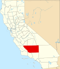
Joe Walker Town | |
---|---|
Coordinates: 35°25′20″N118°29′35″W / 35.42222°N 118.49306°W Coordinates: 35°25′20″N118°29′35″W / 35.42222°N 118.49306°W | |
Country | United States |
State | California |
County | Kern County |
Joe Walker Town is a former settlement in Kern County, California. [1] It was located in the Walker Basin near Joe Walker Mine. [1] The place was named after Joe Walker (as was the mine and basin). [1] At least 100 single miners lived in the town, along with 12 families. [2] The town largely existed to support operations at the Joe Walker Mine. [3]
The Joe Walker gold mine was founded on 20 March 1866 by Hamp Williams, father of another Hamp Williams who discovered silver at Randsburg. Williams sold the mine for $2,000 to investors who could properly equip it. A 20-stamp mill was hauled in from San Francisco. The mine quickly proved to be one of the most profitable in the area, netting $12,000 in six days and a total production over its lifetime of $600,000. However, the mine began to flood faster than it could be pumped out, despite a Cornish engine being shipped in from England. [3]
After several changes of ownership and attempts to restart operations, ending with senator John P. Jones of Nevada in 1873, the mine was mothballed. It was acquired by the Phoebe Hearst estate in lieu of a debt but remained unused for sixty years. It was bought by Tom Duffin in 1939 and reopened in 1941. However, flooding remained a problem and the mine was again abandoned. The mine is now used as a reservoir of water to irrigate crops. [3]
The Sacramento River is the principal river of Northern California in the United States and is the largest river in California. Rising in the Klamath Mountains, the river flows south for 400 miles (640 km) before reaching the Sacramento–San Joaquin River Delta and San Francisco Bay. The river drains about 26,500 square miles (69,000 km2) in 19 California counties, mostly within the fertile agricultural region bounded by the Coast Ranges and Sierra Nevada known as the Sacramento Valley, but also extending as far as the volcanic plateaus of Northeastern California. Historically, its watershed has reached as far north as south-central Oregon where the now, primarily, endorheic (closed) Goose Lake rarely experiences southerly outflow into the Pit River, the most northerly tributary of the Sacramento.
The Bridgwater and Taunton Canal is a canal in the south-west of England between Bridgwater and Taunton, opened in 1827 and linking the River Tone to the River Parrett. There were a number of abortive schemes to link the Bristol Channel to the English Channel by waterway in the 18th and early 19th centuries. These schemes followed the approximate route eventually taken by the Bridgwater and Taunton Canal, but the canal was instead built as part of a plan to link Bristol to Taunton by waterway.
The Colorado River is one of the principal rivers in the Southwestern United States and northern Mexico. The 1,450-mile-long (2,330 km) river drains an expansive, arid watershed that encompasses parts of seven U.S. states and two Mexican states. The name Colorado derives from the Spanish language for "colored reddish" due to its heavy silt load. Starting in the central Rocky Mountains of Colorado, it flows generally southwest across the Colorado Plateau and through the Grand Canyon before reaching Lake Mead on the Arizona–Nevada border, where it turns south toward the international border. After entering Mexico, the Colorado approaches the mostly dry Colorado River Delta at the tip of the Gulf of California between Baja California and Sonora.
The San Joaquin River is the longest river of Central California. The 366-mile (589 km) long river starts in the high Sierra Nevada, and flows through the rich agricultural region of the northern San Joaquin Valley before reaching Suisun Bay, San Francisco Bay, and the Pacific Ocean. An important source of irrigation water as well as a wildlife corridor, the San Joaquin is among the most heavily dammed and diverted of California's rivers.
The Klamath River flows 257 miles (414 km) through Oregon and northern California in the United States, emptying into the Pacific Ocean. By average discharge, the Klamath is the second largest river in California after the Sacramento River. It drains an extensive watershed of almost 16,000 square miles (41,000 km2) that stretches from the arid country of south-central Oregon to the temperate rainforest of the Pacific coast. Unlike most rivers, the Klamath begins in the high desert and flows toward the mountains – carving its way through the rugged Cascade Range and Klamath Mountains before reaching the sea. The upper basin, today used for farming and ranching, once contained vast freshwater marshes that provided habitat for abundant wildlife, including millions of migratory birds. Most of the lower basin remains wild, with much of it designated wilderness. The watershed is known for this peculiar geography, and the Klamath has been called "a river upside down" by National Geographic magazine.
The Truckee River is a river in the U.S. states of California and Nevada. The river flows northeasterly and is 121 miles (195 km) long. The Truckee is the sole outlet of Lake Tahoe and drains part of the high Sierra Nevada, emptying into Pyramid Lake in the Great Basin. Its waters are an important source of irrigation along its valley and adjacent valleys.
Lake Elsinore is a natural freshwater lake in Riverside County, California, located east of the Santa Ana Mountains and fed by the San Jacinto River. Originally named Laguna Grande by Spanish explorers, it was renamed for the town of Elsinore, established on its northeastern shore on April 9, 1888.
The Santa Ana River is the largest river entirely within Southern California in the United States. It rises in the San Bernardino Mountains and flows for most of its length through San Bernardino and Riverside Counties, before cutting through the northern Santa Ana Mountains via Santa Ana Canyon and flowing southwest through urban Orange County to drain into the Pacific Ocean. The Santa Ana River is 96 miles (154 km) long, and its drainage basin is 2,650 square miles (6,900 km2) in size.
The Sevier River is a 400-mile (640 km)-long river in the Great Basin of southwestern Utah in the United States. Originating west of Bryce Canyon National Park, the river flows north through a chain of high farming valleys and steep canyons along the west side of the Sevier Plateau, before turning southwest and terminating in the endorheic basin of Sevier Lake in the Sevier Desert. It is used extensively for irrigation along its course, with the consequence that Sevier Lake is usually dry.
The Walker River is a river in west-central Nevada in the United States, approximately 62 miles (100 km) long. Fed principally by snowmelt from the Sierra Nevada of California, it drains an arid portion of the Great Basin southeast of Reno and flows into the endorheic basin of Walker Lake. The river is an important source of water for irrigation in its course through Nevada; water diversions have reduced its flow such that the level of Walker Lake has fallen 160 feet (49 m) between 1882 and 2010. The river was named for explorer Joseph Reddeford Walker, a mountain man and experienced scout who is known for establishing a segment of the California Trail.
The Kern River, previously Rio de San Felipe, later La Porciuncula, is a Wild and Scenic river in the U.S. state of California, approximately 165 miles (270 km) long. It drains an area of the southern Sierra Nevada mountains northeast of Bakersfield. Fed by snowmelt near Mount Whitney, the river passes through scenic canyons in the mountains and is a popular destination for whitewater rafting and kayaking. It is the southernmost major river system in the Sierra Nevada, and is the only major river in the Sierra that drains in a southerly direction.
Malakoff Diggins State Historic Park is a state park unit preserving the largest hydraulic mining site in California, United States. The mine was one of several hydraulic mining sites at the center of the 1882 landmark case Woodruff v. North Bloomfield Mining and Gravel Company. The mine pit and several Gold Rush-era buildings are listed on the National Register of Historic Places as the Malakoff Diggins-North Bloomfield Historic District. The "canyon" is 7,000 feet (2,100 m) long, as much as 3,000 feet (910 m) wide, and nearly 600 feet (180 m) deep in places. Visitors can see huge cliffs carved by mighty streams of water, results of the mining technique of washing away entire mountains of gravel to wash out the gold. The park is a 26-mile (42 km) drive north-east of Nevada City, California, in the Gold Rush country. The 3,143-acre (1,272 ha) park was established in 1965.
The San Gabriel River is a mostly urban waterway flowing 58 miles (93 km) southward through Los Angeles and Orange Counties, California in the United States. It is the central of three major rivers draining the Greater Los Angeles Area, the others being the Los Angeles River and Santa Ana River. The river's watershed stretches from the rugged San Gabriel Mountains to the heavily developed San Gabriel Valley and a significant part of the Los Angeles coastal plain, emptying into the Pacific Ocean between the cities of Long Beach and Seal Beach.
The Kaweah River is a river draining the southern Sierra Nevada in Tulare County, California in the United States. Fed primarily by high elevation snowmelt along the Great Western Divide, the Kaweah begins as four forks in Sequoia National Park, where the watershed is noted for its alpine scenery and its dense concentrations of giant sequoias, the largest trees on Earth. It then flows in a southwest direction to Lake Kaweah – the only major reservoir on the river – and into the San Joaquin Valley, where it diverges into multiple channels across an alluvial plain around Visalia. With its Middle Fork headwaters starting at almost 13,000 feet (4,000 m) above sea level, the river has a vertical drop of nearly two and a half miles (4.0 km) on its short run to the San Joaquin Valley, making it one of the steepest river drainages in the United States. Although the main stem of the Kaweah is only 33.6 miles (54.1 km) long, its total length including headwaters and lower branches is nearly 100 miles (160 km).
The Bowen Basin contains the largest coal reserves in Australia. This major coal-producing region contains one of the world's largest deposits of bituminous coal. The Basin contains much of the known Permian coal resources in Queensland including virtually all of the known mineable prime coking coal. It was named for the Bowen River, itself named after Queensland's first Governor, Sir George Bowen.
The Bradshaw Mountains are a mountain range in central Arizona, United States, named for brothers Isaac and William D. Bradshaw after their deaths, having been formerly known in English as the Silver Mountain Range.
The Coalinga Oil Field is a large oil field in western Fresno County, California, in the United States. It surrounds the town of Coalinga, about halfway between Los Angeles and San Francisco, to the west of Interstate 5, at the foot of the Diablo Range. Discovered in the late 19th century, it became active around 1890, and is now the eighth-largest oil field in California, with reserves totaling approximately 58 million barrels (9,200,000 m3), and over 1,600 active oil wells. The principal operators on the field, as of 2008, were Chevron Corp. and Aera Energy LLC.
The Juneau mining district is a gold mining area in the U.S. state of Alaska.
The case of Woodruff v. North Bloomfield Gravel Mining Company was a lawsuit brought to California courts in 1882 where a group of local farmers sued North Bloomfield Mining and Gravel Company over damages caused to farmland in the Central Valley. The farmers who brought the suit claimed that the company's hydraulic mining operations resulted in the disposal of excess sediment, debris, and chemicals in local rivers. Prosecutors argued that the debris raised river beds and restricted flow in the rivers leading to heavy man-made flooding. In the years prior, flooding of debris and chemicals had destroyed a large portion of the valley's agriculture.
The Copper Basin, also known as the Ducktown Basin, is a geological region located primarily in Polk County, Tennessee that contains deposits of copper ore and covers approximately 60,000 acres. Located in the southeastern corner of Tennessee, small portions of the basin extend into Fannin County, Georgia and Cherokee County, North Carolina. The basin is surrounded by the Cherokee National Forest and the cities of Ducktown and Copperhill, Tennessee and McCaysville, Georgia are located in the basin.