Rexland Acres, California

Last updated
Rexland Acres
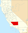
USA California location map.svg
Red pog.svg
Rexland Acres
Location in California
Coordinates: 35°18′18″N118°49′42″W / 35.30500°N 118.82833°W / 35.30500; -118.82833
CountryUnited States
StateFlag of California.svg  California
County Kern
Area
[1]
  Total0.52 sq mi (1.3 km2)
  Land0.52 sq mi (1.3 km2)
  Water0 sq mi (0 km2)
Elevation
[2]
367 ft (112 m)
Population
 (2020)
  Total3,563
  Density6,900/sq mi (2,600/km2)
Time zone UTC-8 (Pacific (PST))
  Summer (DST) UTC-7 (PDT)
ZIP Code
93307
Area code 661
GNIS feature ID2804428 [2]

Rexland Acres is an unincorporated community and census-designated place in Kern County, California.

Geography

Rexland Acres is almost entirely enclaved within the city of Bakersfield, except for a small unincorporated area to the northwest. It is located adjacent to Union Avenue, about 5 miles south of downtown Bakersfield.

Related Research Articles

<span class="mw-page-title-main">Kern County, California</span> County in California, United States

Kern County is a county located in the U.S. state of California. As of the 2020 census, the population was 909,235. Its county seat is Bakersfield.

<span class="mw-page-title-main">San Joaquin County, California</span> County in California, United States

San Joaquin County, officially the County of San Joaquin, is a county located in the U.S. state of California. As of the 2020 census, the population was 779,233. The county seat is Stockton.

<span class="mw-page-title-main">San Luis Obispo County, California</span> County in California, United States

San Luis Obispo County, officially the County of San Luis Obispo, is a county on the Central Coast of California. As of the 2020 census, the population was 282,424. The county seat is San Luis Obispo.

<span class="mw-page-title-main">Bay Point, California</span> CDP in California, United States

Bay Point, formerly West Pittsburg and originally Bella Vista is a census-designated place located in the East Bay region of the San Francisco Bay Area in Contra Costa County, California. Bay Point is just west of Pittsburg, California, and northeast of Concord, California, on the southern shore of Suisun Bay. The population of Bay Point was 21,349 as of 2010. The Pittsburg/Bay Point Station of the Bay Area Rapid Transit (BART) rail system is located adjacent to Bay Point in Pittsburg. The community is traversed by a freeway, State Route 4, the California Delta Highway. Being unincorporated, Bay Point does not have its own police department. The community is policed by the California Highway Patrol and the Contra Costa County Sheriff's Office. The ZIP code is 94565, and the area code is 925.

<span class="mw-page-title-main">Bakersfield, California</span> City in California, United States

Bakersfield is a city in Kern County, California, United States. Bakersfield is the county seat of Kern County and is the largest city and the capital of Kern County. The city covers about 151 sq mi (390 km2) near the southern end of the San Joaquin Valley, which is located in the Central Valley region.

<span class="mw-page-title-main">Lake of the Woods, California</span> Census-designated place in California, United States

Lake of the Woods is an unincorporated area and census-designated place (CDP) in southwestern Kern County, California. As of the 2020 census, the population was 790.

<span class="mw-page-title-main">Mettler, California</span> Census-designated place in California, United States

Mettler, or Mettler Station, is a heavily Hispanic, low-income unincorporated area and census-designated place in Kern County, California. The population was 90 at the 2020 census, down from 136 at the 2010 census. It is the place where motion picture actor James Dean received a traffic ticket on the last day of his life.

<span class="mw-page-title-main">Oildale, California</span> Census-designated place in California, United States

Oildale is a census-designated place (CDP) in Kern County, California, United States. Oildale is located 3.5 miles (5.6 km) north-northwest of downtown Bakersfield, at an elevation of 469 feet (143 m). The population was 32,684 at the 2010 census, up from 27,885 at the 2000 census. It is an unincorporated suburban town just north of Bakersfield across the Kern River, west of the Kern River Oil Field, and east of Highway 99.

<span class="mw-page-title-main">Pine Mountain Club, California</span> Census-designated place in California, United States

Pine Mountain Club is an unincorporated area and census-designated place in southwestern Kern County, California. As of the 2010 census it had a population of 2,315.

<span class="mw-page-title-main">Weedpatch, California</span> Census-designated place in California, United States

Weedpatch is an unincorporated community and census-designated place (CDP) in Kern County, California, United States. Weedpatch is 10 miles (16 km) south-southeast of Bakersfield. It is considered to be one of the poorest areas in Kern County. As of the 2010 census it had a population of 2,658.

<span class="mw-page-title-main">Bakersfield, Vermont</span> Town in Vermont, United States

Bakersfield is a town in Franklin County, Vermont, United States. The population was 1,273 at the 2020 census.

<span class="mw-page-title-main">San Joaquin Valley</span> Area of the Central Valley in California

The San Joaquin Valley is the area of the Central Valley of the U.S. state of California that lies south of the Sacramento–San Joaquin River Delta and is drained by the San Joaquin River. It comprises eight counties of Northern and one of Southern California, including, in the north, all of San Joaquin and Kings counties, most of Stanislaus, Merced, and Fresno counties, and parts of Madera and Tulare counties, along with a majority of Kern County, in Southern California. Although the valley is predominantly rural, it has densely populated urban centers: Fresno, Bakersfield, Stockton, Modesto, Porterville, Tulare, Visalia, and Merced.

<span class="mw-page-title-main">Lake Isabella</span> Reservoir in California, United States

Lake Isabella also called Isabella Lake, is a reservoir in Kern County, California, United States created by the earthen Isabella Dam. At 11,000 acres (4,500 ha), it is one of the larger reservoirs in California. Lake Isabella is located about 40 miles (64 km) northeast of Bakersfield, and is the main water supply for that city. It was formed in 1953 when the U.S. Army Corps of Engineers dammed the Kern River at the junction of its two forks. The area is in the southern end of the Sierra Nevada range and the lake itself is located in low mountains at an elevation of approximately 2,500 ft (760 m) where summer temperatures reach over 100 °F (38 °C) but low enough to avoid winter snows on the surrounding ridges. The former towns of Isabella and Kernville were flooded when the reservoir was created.

East Bakersfield is a region in Bakersfield, California directly east of downtown. The region was formerly known as the town of Sumner, which was later incorporated and renamed Kern City. It is primarily a mixture of residential and commercial developments. It also contains a small business district centered on the intersection of Baker and Sumner streets. Census data is provided on the right for the time period when the region was an independent town and city. It is part of the Bakersfield urban area of almost 500,000 people.

Alameda is an unincorporated community in Kern County, California. It is located 9 miles (14 km) south of Bakersfield, at an elevation of 331 feet (101 m).

<span class="mw-page-title-main">Fuller Acres, California</span> Census-designated place in California, United States

Fuller Acres is a census-designated place in Kern County, California. It is located 7.25 miles (12 km) southeast of downtown Bakersfield, at an elevation of 420 feet (128.02 m). The population was 991 at the 2010 census.

Hilmar is an unincorporated community in Merced County, California, United States. It is located 4.25 miles (6.8 km) west-southwest of Delhi, spanning 3.9 sq mi (10 km2) and at an elevation of 92 ft (28 m) above sea level. For census purposes, Hilmar is aggregated with a nearby community into the Hilmar-Irwin census-designated place, which had 5,164 residents as of the 2020 census.

Bakersfield Country Club is an 18-hole private golf course located in Bakersfield, California. The course is 6,819 yards on hilly terrain, designed by William P. Bell. Being located in the foothills of northeast Bakersfield makes this one of the few courses within Kern County that is naturally hilly. The club has reciprocating privileges to all private golf clubs in the Greater Bakersfield area. It is a championship course, which has hosted the Bakersfield Open Invitational between 1961 and 1962, which was a tournament on the PGA Tour.

References