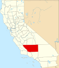
Choctaw Valley, California

Last updated
Choctaw Valley, California
Country United States
State California
County Kern County

Choctaw Valley is the name of multiple neighborhoods and a census-designated place (CDP) in Kern County, California.

Contents

Choctaw Valley sits mostly on the north bank of the Kern River, [1] or straddles the river until it abuts the Alfred Harrell Hwy. [2]

The area is in the Bakersfield CCD and ZIP Code Tabulation Area 93308.

The neighborhoods belong to the nearby communities of Bakersfield and Rivergrove. [3]

Census-designated place

The CDP of Choctaw Valley was first listed in the 2020 census, [4] at which time it had a population of 237 in 48 households. [5]

93308

In the larger ZIP Code Tabulation Area that encompasses the area, there was a population of 52,447 at the 2020 census and 54,857 for the 2021 American Community Survey 5-Year estimate. [6]

Related Research Articles

<span class="mw-page-title-main">Kern County, California</span> County in California, United States

Kern County is a county located in the U.S. state of California. As of the 2020 census, the population was 909,235. Its county seat is Bakersfield.

<span class="mw-page-title-main">Bakersfield, California</span> City in California, United States

Bakersfield is a city in Kern County, California, United States. It is the county seat and largest city of Kern County. The city covers about 151 sq mi (390 km2) near the southern end of the San Joaquin Valley and the Central Valley region. Bakersfield's population as of the 2020 census was 403,455, making it the 48th most populous city in the United States of America and the 9th most populous city in California. The Bakersfield–Delano Metropolitan Statistical Area, which includes all of Kern County, had a 2020 census population of 909,235, making it the 62nd largest metropolitan area in the United States. The urban area that includes Bakersfield and areas immediately around the city, such as East Bakersfield, Oildale, and Rosedale, has a population of 570,235.

<span class="mw-page-title-main">Inyokern, California</span> Census designated place in California, United States

Inyokern is a census-designated place (CDP) in Kern County, California, United States. Its name derives from its location near the border between Inyo and Kern Counties. Inyokern is located 8 miles (13 km) west of Ridgecrest, at an elevation of 2,434 feet (742 m). It is on the western side of the Indian Wells Valley. The population was 988 in the 2020 census, down from 1,099 in the 2010 census. It was a railroad town established along the Southern Pacific railroad's Lone Pine Branch and with WWII became site of the Naval Air Weapons Station China Lake.

<span class="mw-page-title-main">Lake Isabella, California</span> Census-designated place in California, United States

Lake Isabella is a census-designated place (CDP) in the southern Sierra Nevada, in Kern County, California, United States. It is named after the Lake Isabella reservoir and located at its southwestern edge, 6 miles (9.7 km) south of Wofford Heights in the Kern River Valley.

<span class="mw-page-title-main">Lake of the Woods, California</span> Census-designated place in California, United States

Lake of the Woods is an unincorporated area and census-designated place (CDP) in southwestern Kern County, California. As of the 2020 census, the population was 790.

<span class="mw-page-title-main">Mojave, California</span> Unincorporated community in California, United States

Mojave is an unincorporated community in Kern County, California, United States. Mojave is located 50 miles (80 km) east of Bakersfield, and 100 miles (161 km) north of Los Angeles, at an elevation of 2,762 feet (842 m). The town is located in the western region of the Mojave Desert, below and east of Oak Creek Pass and the Tehachapi Mountains. Mojave is on the Pacific Crest Trail.

<span class="mw-page-title-main">Weedpatch, California</span> Census-designated place in California, United States

Weedpatch is an unincorporated community and census-designated place (CDP) in Kern County, California, United States. Weedpatch is 10 miles (16 km) south-southeast of Bakersfield. It is considered to be one of the poorest areas in Kern County. As of the 2010 census it had a population of 2,658.

<span class="mw-page-title-main">Del Aire, California</span> Census-designated place in California, United States

Del Aire is a census-designated place (CDP) in the inland South Bay, Los Angeles County, California, United States, between El Segundo and Hawthorne. The population was 10,001 at the 2010 census, up from 9,012 at the 2000 census.

<span class="mw-page-title-main">West Athens, California</span> Unincorporated community in California, United States

West Athens is a census-designated place (CDP) in Los Angeles County, California. The population was 9,393 at the 2020 census. It is an unincorporated community within the 2nd Supervisorial District of Los Angeles County. West Athens is served by the Los Angeles County Sheriff's Department, operating out of the South Los Angeles Station. The approximate boundaries for West Athens are: 87th Street to the north, Vermont Avenue to the east, El Segundo Boulevard to the south, and approximately Western Avenue to Van Ness Avenue to the west. West Athens is predominantly residential, with commercial uses along its main corridors. Los Angeles Southwest Community College lies within the West Athens neighborhood and city limits.

<span class="mw-page-title-main">West Carson, California</span> Place in California, United States

West Carson is an unincorporated community in Los Angeles County, California. The population was 21,699 at the 2010 census, up from 21,138 at the 2000 census. For statistical purposes, the United States Census Bureau has defined West Carson as a census-designated place (CDP).

<span class="mw-page-title-main">Glenvar Heights, Florida</span> Census-designated place in Florida, United States

Glenvar Heights is a census-designated place (CDP) and neighborhood in Miami-Dade County, Florida, United States. The population was 20,786 at the 2020 census, up from 16,898 in 2010. The community is served by the Miami ZIP codes 33143 and 33155.

<span class="mw-page-title-main">Alviso, San Jose</span> Neighborhood of San Jose in San Francisco Bay Area, California, United States

Alviso is a district of San Jose, California, located in North San Jose on the southern shores of San Francisco Bay. Originally an independent town, founded in 1852, today Alviso is San Jose's only waterfront district, primarily residential in nature, with several Silicon Valley tech companies and recreation-oriented businesses. Alviso is named after 19th-century Californio ranchero Ignacio Alviso, who owned the area as part of his Rancho Rincón de Los Esteros.

<span class="mw-page-title-main">Redwood Valley, California</span> Census-designated place in California, United States

Redwood Valley is a census-designated place (CDP) in Mendocino County, California, United States. It is located 9 miles (14 km) north of Ukiah, the county seat, at an elevation of 722 feet (220 m), and comprises the northern portion of the Ukiah Valley. It is about 15 miles (24 km) southeast of Willits. Potter Valley is to the east and Calpella to the south. The ZIP Code is 95470, and the community is in area code 707. The population of the CDP was 1,843 at the 2020 census.

<span class="mw-page-title-main">Havilah, California</span> Unincorporated community in California, United States

Havilah is an unincorporated community in Kern County, California. It is located in the mountains between Walker Basin and the Kern River Valley, 5 miles (8.0 km) south-southwest of Bodfish at an elevation of 3,136 feet (956 m).

<span class="mw-page-title-main">Fuller Acres, California</span> Census-designated place in California, United States

Fuller Acres is a census-designated place in Kern County, California. It is located 7.25 miles (12 km) southeast of downtown Bakersfield, at an elevation of 420 feet (128.02 m). The population was 991 at the 2010 census.

Red Rock is an unincorporated community and census-designated place (CDP) in Apache County, Arizona, United States. Red Rock is located on the Navajo Nation near the New Mexico border, 16 miles (26 km) northeast of Lukachukai. Red Rock has a post office with ZIP code 86544; the post office uses the Red Valley name. As of the 2010 census, the Red Rock CDP had a population of 169.

Olde Stockdale is a neighborhood and census-designated place in Kern County, California. The population was 568 at the 2020 census.

Benton Park is a census-designated place (CDP) in Kern County, California. Although it is designated by the census as its own place, it is functionally a neighborhood of Bakersfield.

Casa Loma is a census-designated place (CDP) in Kern County, California. Although it is designated by the census as its own place, it is functionally a neighborhood of Bakersfield.

Rivergrove is a census-designated place (CDP) in Kern County, California. Although it is designated by the census as its own place, it is functionally a neighborhood of Bakersfield.

References

  1. "Choctaw Valley Homes for Sale: Choctaw Valley, CA Real Estate". Redfin . Retrieved 2023-03-10.
  2. "Choctaw Valley, Bakersfield, CA". realtor.com®. Retrieved 2023-03-10.
  3. "Choctaw Valley, Rivergrove, CA Real Estate & Homes for Sale". RE/MAX . Retrieved 2023-03-10.
  4. "Choctaw Valley CDP, California". Explore Census Data. U.S. Census Bureau . Retrieved 2023-02-27.
  5. "Choctaw Valley CDP, California". Explore Census Data. U.S. Census Bureau . Retrieved 2023-02-27.
  6. "ZCTA5 93308". Explore Census Data. U.S. Census Bureau . Retrieved 2023-02-27.

Coordinates: 35°26′18″N118°52′52″W / 35.43833°N 118.88111°W / 35.43833; -118.88111