Spring Valley Lake, California

Last updated

Spring Valley Lake
Spring Valley Lake, Victor Valley, California.jpg
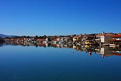
Homes surrounding the Spring Valley Lake
USA California location map.svg
Red pog.svg
Spring Valley Lake
Position in California.
Coordinates: 34°29′50″N117°16′08″W / 34.49722°N 117.26889°W / 34.49722; -117.26889
Country Flag of the United States.svg  United States
State Flag of California.svg  California
County San Bernardino
Area
[1]
  Total3.533 sq mi (9.149 km2)
  Land2.969 sq mi (7.689 km2)
  Water0.564 sq mi (1.460 km2)  15.95%
Elevation
[2]
2,779 ft (847 m)
Population
 (2010)
  Total8,220
  Density2,300/sq mi (900/km2)
Time zone UTC-8 (Pacific (PST))
  Summer (DST) UTC-7 (PDT)
GNIS feature ID2583150
U.S. Geological Survey Geographic Names Information System: Spring Valley Lake, California

Spring Valley Lake is a census-designated place in the Victor Valley of the Mojave Desert, within San Bernardino County, California. [2] It is located along the Mojave River.

Contents

Geography

Spring Valley Lake sits at an elevation of 2,779 feet (847 m). [2]

According to the United States Census Bureau, the CDP covers an area of 3.5 square miles (9.1 km2), 3.0 square miles (7.7 km2) of it land, and 0.6 square miles (1.5 km2) of it (15.95%) water.

Demographics

At the 2010 census Spring Valley Lake had a population of 8,220. The population density was 2,327.0 inhabitants per square mile (898.5/km2). The racial makeup of Spring Valley Lake was 6,450 (78.5%) White (68.1% Non-Hispanic White), [3] 403 (4.9%) African American, 55 (0.7%) Native American, 381 (4.6%) Asian, 23 (0.3%) Pacific Islander, 481 (5.9%) from other races, and 427 (5.2%) from two or more races. Hispanic or Latino of any race were 1,528 persons (18.6%). [4]

The whole population lived in households, no one lived in non-institutionalized group quarters, and no one was institutionalized.

There were 3,072 households, 1,054 (34.3%) had children under the age of 18 living in them, 1,808 (58.9%) were opposite-sex married couples living together, 347 (11.3%) had a female householder with no husband present, 159 (5.2%) had a male householder with no wife present. There were 149 (4.9%) unmarried opposite-sex partnerships, and 22 (0.7%) same-sex married couples or partnerships. 596 households (19.4%) were one person and 294 (9.6%) had someone living alone who was 65 or older. The average household size was 2.68. There were 2,314 families (75.3% of households); the average family size was 3.06.

The age distribution was 1,932 people (23.5%) under the age of 18, 712 people (8.7%) aged 18 to 24, 1,842 people (22.4%) aged 25 to 44, 2,375 people (28.9%) aged 45 to 64, and 1,359 people (16.5%) who were 65 or older. The median age was 41.3 years. For every 100 females, there were 95.2 males. For every 100 females age 18 and over, there were 92.2 males.

There were 3,478 housing units at an average density of 984.6 per square mile, of the occupied units 2,273 (74.0%) were owner-occupied and 799 (26.0%) were rented. The homeowner vacancy rate was 3.2%; the rental vacancy rate was 7.7%. 5,694 people (69.3% of the population) lived in owner-occupied housing units and 2,526 people (30.7%) lived in rental housing units.

According to the 2010 United States Census, Spring Valley Lake had a median household income of $58,317, with 9.5% of the population living below the federal poverty line. [3]

Related Research Articles

<span class="mw-page-title-main">Shaver Lake, California</span> Census-designated place in California, United States

Shaver Lake is a census-designated place (CDP) in Fresno County, California, United States. The population was 634 at the 2010 census, down from 705 at the 2000 census. Shaver Lake is on the southwest end of the lake of the same name, 10 miles (16 km) east of New Auberry, at an elevation of 5,627 ft (1,715 m). The name honors C.B. Shaver, founder of the Fresno Flume and Irrigation Company that built the dam, creating the lake. The lake served as a mill pond for the Shaver Sawmill and the source for a flume that ran 65 miles (105 km) to Clovis. The original town of Shaver was buried under the lake when the Thomas A. Edison Company purchased and enlarged the lake in 1919.

<span class="mw-page-title-main">Lake Isabella, California</span> Census-designated place in California, United States

Lake Isabella is a census-designated place (CDP) in the southern Sierra Nevada, in Kern County, California, United States. It is named after the Lake Isabella reservoir and located at its southwestern edge, 6 miles (9.7 km) south of Wofford Heights in the Kern River Valley.

<span class="mw-page-title-main">Rosamond, California</span> Unincorporated community in Kern County, California

Rosamond is an unincorporated community in Kern County, California, US, near the Los Angeles county line. Rosamond is part of Greater Los Angeles and is located in the Mojave Desert just north of Lancaster and Palmdale, two of the largest cities in Antelope Valley. As of the 2010 Census, Rosamond's population was 18,150. For statistical purposes, the United States Census Bureau has defined Rosamond as a census-designated place (CDP).

<span class="mw-page-title-main">Squirrel Mountain Valley, California</span> Census-designated place in California, United States

Squirrel Mountain Valley is a census-designated place (CDP) in the southern Sierra Nevadas, in Kern County, California, United States. Squirrel Mountain Valley is located in the Lake Isabella area 5 miles (8 km) northeast of Bodfish, at an elevation of 2,900 feet (883.9 m). The population was 547 at the 2010 census, up from 498 at the 2000 census.

<span class="mw-page-title-main">Hidden Valley Lake, California</span> Census-designated place in California, United States

Hidden Valley Lake is a census-designated place (CDP) and gated subdivision in Lake County, California, United States. The population was 6,235 at the 2020 census, up from 5,579 at the 2010 census. Today, it is a CID known as Hidden Valley Lake Association (HVLA).

<span class="mw-page-title-main">Upper Lake, California</span> Census-designated place in California, United States

Upper Lake is a census-designated place (CDP) in Lake County, California, United States. Upper Lake is located 8 miles (13 km) north of Lakeport, at an elevation of 1,345 feet (410 m). The population was 1,052 at the 2010 census, up from 989 at the 2000 census. The Habematolel Pomo of Upper Lake are headquartered here.

<span class="mw-page-title-main">Lake Davis, California</span> Census-designated place in California, United States

Lake Davis is a census-designated place (CDP) in Plumas County, California, United States, located on Lake Davis. The population was 45 at the 2010 census.

<span class="mw-page-title-main">Lenwood, California</span> Census-designated place in California, United States

Lenwood is a census-designated place (CDP) in the Mojave Desert near Barstow, in San Bernardino County, California.

<span class="mw-page-title-main">Mountain View Acres, California</span> Census-designated place in California, United States

Mountain View Acres is a census-designated place (CDP) in the Victor Valley of the Mojave Desert, within San Bernardino County, California.

<span class="mw-page-title-main">La Presa, California</span> Census-designated place in California, United States

La Presa is a census-designated place (CDP) in the East County region of San Diego County, California, United States. The population was 34,169 at the 2010 census, up from 32,721 at the 2000 census.

<span class="mw-page-title-main">Spring Valley, San Diego County, California</span> Census-designated place in California, United States

Spring Valley is a census-designated place (CDP) in the East County region of San Diego County, California. The population was 28,205 at the time of the 2010 census.

<span class="mw-page-title-main">Stallion Springs, California</span> Census-designated place in California, United States

Stallion Springs is a census-designated place (CDP) in the Tehachapi Mountains, in Kern County, California, USA. The population was 2,488 at the 2010 census, up from 1,522 at the 2000 census. Stallion Springs is located in Cummings Valley within the Greater Tehachapi area.

<span class="mw-page-title-main">Helendale, California</span> Unincorporated community in California, United States

Helendale or Silver Lakes is an unincorporated community and census-designated place located in the Victor Valley of the Mojave Desert, within San Bernardino County, California.

<span class="mw-page-title-main">Elizabeth Lake, California</span> Census-designated place in California, United States

Elizabeth Lake is a census-designated place (CDP) and unincorporated community on Elizabeth Lake (lake), in Los Angeles County, California, United States. As of the 2010 census it had a population of 1,756.

Oak Hills is a census-designated place in the Victor Valley of the Mojave Desert, within San Bernardino County, California.

<span class="mw-page-title-main">Searles Valley, California</span> Census-designated place in California, United States

Searles Valley is a census-designated place (CDP) in the Searles Valley of the Mojave Desert, in northwestern San Bernardino County, California.

<span class="mw-page-title-main">Aspen Springs, California</span> Census-designated place in California, United States

Aspen Springs is an unincorporated community and census-designated place (CDP) in Mono County, California, United States. It lies at an elevation of 7,109 feet (2,167 m). The population was 70 at the 2020 census.

Spring Valley is a census-designated place in Lake County, California. Spring Valley sits at an elevation of 1,581 feet (482 m). The 2010 United States census reported Spring Valley's population was 845.

<span class="mw-page-title-main">Lake Mathews, California</span> Census-designated place in California, United States

Lake Mathews is a census-designated place in Riverside County, California. Lake Mathews sits at an elevation of 1,775 feet (541 m). The 2010 United States census reported Lake Mathews's population was 5,890.

<span class="mw-page-title-main">Lake California, California</span> Census-designated place in California, United States

Lake California is a census-designated place (CDP) in Tehama County, California. Lake California sits at an elevation of 597 feet (182 m). The 2010 United States census reported Lake California's population was 3,054.

References

  1. U.S. Census Archived 2012-01-25 at the Wayback Machine
  2. 1 2 3 U.S. Geological Survey Geographic Names Information System: Spring Valley Lake, California
  3. 1 2 "QuickFacts". United States Census Bureau . Archived from the original on April 18, 2012. Retrieved July 8, 2023.{{cite web}}: CS1 maint: unfit URL (link)
  4. "2010 Census Interactive Population Search: CA - Spring Valley Lake CDP". U.S. Census Bureau. Archived from the original on July 15, 2014. Retrieved July 12, 2014.