Searles Valley | |
---|---|
Coordinates: 35°45′55″N117°22′58″W / 35.76528°N 117.38278°W | |
Country | United States |
State | California |
County | San Bernardino |
Area | |
• Total | 10.494 sq mi (27.180 km2) |
• Land | 10.494 sq mi (27.180 km2) |
• Water | 0 sq mi (0 km2) 0% |
Population (2010) | |
• Total | 1,739 |
• Density | 170/sq mi (64/km2) |
Time zone | UTC-8 (PST) |
• Summer (DST) | UTC-7 (PDT) |
ZIP code | 93562 |
Area code | 760 |
FIPS code | 06-70728 |
GNIS feature ID | 2409296 |
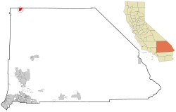
Searles Valley is a census-designated place (CDP) in the Searles Valley of the Mojave Desert, in northwestern San Bernardino County, California.
Searles Valley includes the unincorporated communities of Argus, Pioneer Point, Searles Valley (town), and Trona. Searles Valley is located at 35°45′55″N117°22′58″W / 35.765181°N 117.382803°W (35.765181, -117.382803). [2]
Searles Valley CDP is at the western edge of Searles Lake, a dry lakebed in the lowest part of the Searles Valley.
Searles Valley CDP is about 170 miles northeast of Los Angeles, on State Route 178. It is southwest of Death Valley and the Panamint Range. Ridgecrest and China Lake are to the west.
According to the United States Census Bureau, Searles Valley has a total area of 27.2 km2 (10.5 sq mi), all land. The population was 1,739 at the 2010 census. The ZIP code is 93562 and the area code 760.
The Searles Lake is an endorheic dry lake formed by the evaporation of lakes during the late Quaternary period. It contains rich deposits of chemicals, including borax and rock salt. [3]
Searles Valley is known for its isolation and desolation, [4] as well as the nearby Trona Pinnacles a few miles to the south. The Trona Pinnacles are an unusual landscape of more than 500 tufa spires, some as high as 140 feet, rising from the bed of the Searles Lake basin.
The name Trona is derived from the mineral trona, abundant in the lake. The local school plays on a dirt football field because the high level of salt kills grass.
In July 2019, Searles Valley was impacted by a series of earthquakes, the principal events (with magnitudes of 6.4, 5.4, and 7.1 Mw ) occurring from 12 to 18 kilometers west on the Naval Air Weapons Station China Lake. [5] The earthquake series started at 10:02 AM on July 4 with a Mw 4.0 earthquake 4 kilometers southwest of Searles Valley. At 10:33 AM a second and much stronger earthquake struck – a 6.4 magnitude quake 12 kilometers southwest of Searles Valley. [6] The earthquake was felt throughout the area and Southern California, including Los Angeles, and in Nevada, including Las Vegas. The earthquake was 10.5 kilometers deep. [7] Over 100 aftershocks impacted Searles Valley and nearby Ridgecrest, California.[ citation needed ] This second quake was followed by an even larger 7.1 magnitude quake, subsequently designated the main quake in the series, on Friday, July 5, 2019, at approximately 8:18 PM.
Approximately 6:36 PM on July 22, 2019, the valley received a 3.9 magnitude quake.
In the state legislature Searles Valley is located in California's 16th State Senate district, represented by Republican Roy Ashburn, and in California's 33rd State Assembly district, represented by Republican Tim Donnelly.
The 2010 United States Census [8] reported that Searles Valley had a population of 1,739. The population density was 165.7 inhabitants per square mile (64.0/km2). The racial makeup of Searles Valley was 1,405 (80.8%) White (72.3% Non-Hispanic White), [9] 69 (4.0%) African American, 56 (3.2%) Native American, 16 (0.9%) Asian, 6 (0.3%) Pacific Islander, 83 (4.8%) from other races, and 104 (6.0%) from two or more races. Hispanic or Latino of any race were 293 persons (16.8%).
The Census reported that 1,739 people (100% of the population) lived in households, 0 (0%) lived in non-institutionalized group quarters, and 0 (0%) were institutionalized.
There were 722 households, out of which 215 (29.8%) had children under the age of 18 living in them, 309 (42.8%) were opposite-sex married couples living together, 92 (12.7%) had a female householder with no husband present, 52 (7.2%) had a male householder with no wife present. There were 48 (6.6%) unmarried opposite-sex partnerships, and 3 (0.4%) same-sex married couples or partnerships. 223 households (30.9%) were made up of individuals, and 80 (11.1%) had someone living alone who was 65 years of age or older. The average household size was 2.41. There were 453 families (62.7% of all households); the average family size was 3.01.
The population was spread out, with 436 people (25.1%) under the age of 18, 171 people (9.8%) aged 18 to 24, 342 people (19.7%) aged 25 to 44, 515 people (29.6%) aged 45 to 64, and 275 people (15.8%) who were 65 years of age or older. The median age was 40.7 years. For every 100 females, there were 104.1 males. For every 100 females age 18 and over, there were 101.4 males.
There were 961 housing units at an average density of 91.6 units per square mile (35.4 units/km2), of which 439 (60.8%) were owner-occupied, and 283 (39.2%) were occupied by renters. The homeowner vacancy rate was 1.5%; the rental vacancy rate was 8.4%. 1,041 people (59.9% of the population) lived in owner-occupied housing units and 698 people (40.1%) lived in rental housing units.
According to the 2010 United States Census, Searles Valley had a median household income of $32,448, with 21.7% of the population living below the federal poverty line. [10]
As of the 2000 United States Census [11] of 2000, there were 1,885 people, 738 households, and 495 families residing in the CDP. The population density was 61.9 people/km2 (160 people/sq mi). There were 1,051 housing units at an average density of 34.5 units/km2 (89 units/sq mi). The racial makeup of the CDP was 86.3% White, 1.5% African American, 2.4% Native American, 0.7% Asian, 0.4% Pacific Islander, 5.0% from other races, and 3.7% from two or more races. Hispanic or Latino of any race were 16.2% of the population.
There were 738 households, out of which 33.2% had children under the age of 18 living with them, 49.3% were married couples living together, 12.9% had a female householder with no husband present, and 32.9% were non-families. 29.3% of all households were made up of individuals, and 10.6% had someone living alone who was 65 years of age or older. The average household size was 2.55 and the average family size was 3.16.
In the CDP, the population was spread out, with 30.9% under the age of 18, 8.2% from 18 to 24, 25.3% from 25 to 44, 24.9% from 45 to 64, and 10.7% who were 65 years of age or older. The median age was 36 years. For every 100 females, there were 104.2 males. For every 100 females age 18 and over, there were 99.1 males.
The median income for a household in the CDP was $35,833, and the median income for a family was $37,143. Males had a median income of $44,397 versus $35,625 for females. The per capita income for the CDP was $16,861. About 18.2% of families and 21.4% of the population were below the poverty line, including 33.0% of those under age 18 and 10.1% of those age 65 or over.
Mentone is a town in DeKalb County, Alabama, United States. It is located atop Lookout Mountain.
Shaver Lake is a census-designated place (CDP) in Fresno County, California, United States. The population was 634 at the 2010 census, down from 705 at the 2000 census. Shaver Lake is on the southwest end of the lake of the same name, 10 miles (16 km) east of New Auberry, at an elevation of 5,627 ft (1,715 m). The name honors C.B. Shaver, founder of the Fresno Flume and Irrigation Company that built the dam, creating the lake. The lake served as a mill pond for the Shaver Sawmill and the source for a flume that ran 65 miles (105 km) to Clovis. The original town of Shaver was buried under the lake when the Thomas A. Edison Company purchased and enlarged the lake in 1919.
Big Pine is a census-designated place (CDP) in Inyo County, California, United States. Big Pine is located approximately 15 miles (24 km) south-southeast of Bishop. The population was 1,756 at the 2010 census, up from 1,350 at the 2000 census. The Big Pine Band of Owens Valley Paiute Shoshone Indians of the Big Pine Reservation operates their tribal headquarters from here.
Inyokern is a census-designated place (CDP) in Kern County, California, United States. Its name derives from its location near the border between Inyo and Kern Counties. Inyokern is located 8 miles (13 km) west of Ridgecrest, at an elevation of 2,434 feet (742 m). It is on the western side of the Indian Wells Valley. The population was 988 in the 2020 census, down from 1,099 in the 2010 census. It was a railroad town established along the Southern Pacific railroad's Lone Pine Branch and with WWII became site of the Naval Air Weapons Station China Lake.
Johannesburg is a census-designated place (CDP) in Kern County, California, in a mining district of the Rand Mountains. Johannesburg is located 1 mile (1.6 km) east-northeast of Randsburg, at an elevation of 3,517 feet (1,072 m). The terminus of the Randsburg Railway was here from 1897 to 1933. The population was 172 at the 2010 census, down from 176 at the 2000 census. Johannesburg is divided from the neighboring community of Randsburg by a ridge. The town is frequently referred to as "Jo-burg" by locals and frequent visitors to the northwest Mojave.
Ridgecrest is a city in Kern County, California, United States, along U.S. Route 395 in the Indian Wells Valley in northeastern Kern County, adjacent to the Naval Air Weapons Station China Lake. It was incorporated as a city in 1963. The population was 27,959 at the 2020 census, up slightly from 27,616 at the 2010 census.
Rosamond is an unincorporated community in Kern County, California, US, near the Los Angeles county line. Rosamond is part of Greater Los Angeles and is located in the Mojave Desert just north of Lancaster and Palmdale, two of the largest cities in Antelope Valley. As of the 2010 Census, Rosamond's population was 18,150. For statistical purposes, the United States Census Bureau has defined Rosamond as a census-designated place (CDP).
Squirrel Mountain Valley is a census-designated place (CDP) in the southern Sierra Nevadas, in Kern County, California, United States. Squirrel Mountain Valley is located in the Lake Isabella area 5 miles (8 km) northeast of Bodfish, at an elevation of 2,900 feet (883.9 m). The population was 547 at the 2010 census, up from 498 at the 2000 census.
Hidden Valley Lake is a census-designated place (CDP) and gated subdivision in Lake County, California. It is a common-interest development managed by the Hidden Valley Lake Association (HVLA). Its population was 6,235 at the 2020 census, up from 5,579 at the 2010 census.
Tamalpais-Homestead Valley is a census-designated place (CDP) in Marin County, California, United States. The population was 11,492 at the 2020 census.
Tomales is a census-designated place (CDP) on State Route 1 in Marin County, California, United States. The population was 187 at the 2020 census.
Crestline is a census-designated place in the San Bernardino Mountains of San Bernardino County, California, USA. The population was 10,770 at the 2010 census, up from 10,218 at the 2000 census.
Valley Center is a census-designated place (CDP) in San Diego County, California, United States. The population was 9,277 at the 2010 census.
Moodus is a village in the town of East Haddam, Connecticut, United States. The village is the basis of a census-designated place (CDP) of the same name. The population of the CDP was 1,982 as of the census of 2020.
Ridgecrest is a census-designated place (CDP) in Pinellas County, Florida, United States. The population was 2,558 at the 2010 census.
Chalfant is an unincorporated community and census-designated place (CDP) in Mono County, California, United States. It is located on the abandoned Southern Pacific Railroad 22 miles (35 km) south-southeast of Benton, at an elevation of 4,258 feet (1,298 m). The population was 660 at the 2020 census.
Trona is an unincorporated community in San Bernardino County, California. In 2015 it had a population of approximately 1,900. Trona is at the western edge of Searles Lake, a dry lake bed in Searles Valley, southwest of Death Valley. The town takes its name from the mineral trona, abundant in the lakebed. It is about 170 miles (274 km) northeast of Los Angeles, on State Route 178. The ZIP code is 93562.
Trona is a census-designated place in Inyo County, California, adjacent to the unincorporated community of Trona, San Bernardino County, California. The 2010 United States census reported Trona's population was 18.
Spring Valley Lake is a census-designated place in the Victor Valley of the Mojave Desert, within San Bernardino County, California. It is located along the Mojave River.
The 2019 Ridgecrest earthquakes of July 4 and 5 occurred north and northeast of the town of Ridgecrest, California located in Kern County and west of Searles Valley. They included three initial main shocks of Mw magnitudes 6.4, 5.4, and 7.1, and many perceptible aftershocks, mainly within the area of the Naval Air Weapons Station China Lake. Eleven months later, a Mw 5.5 aftershock took place to the east of Ridgecrest. The first main shock occurred on Thursday, July 4 at 10:33 a.m. PDT, approximately 18 km (11.2 mi) ENE of Ridgecrest, and 13 km (8.1 mi) WSW of Trona, on a previously unnoticed NE-SW trending fault where it intersects the NW-SE trending Little Lake Fault Zone. This quake was preceded by several smaller earthquakes, and was followed by more than 1,400 detected aftershocks. The M 5.4 and M 7.1 quakes struck on Friday, July 5 at 4:08 a.m. and 8:19 p.m. PDT approximately 10 km (6 miles) to the northwest. The latter, now considered the mainshock, was the most powerful earthquake to occur in the state in 20 years. Subsequent aftershocks extended approximately 50 km (~30 miles) along the Little Lake Fault Zone.