
San Bernardino County, officially the County of San Bernardino, is a county located in the southern portion of the U.S. state of California, and is located within the Inland Empire area. As of the 2010 U.S. Census, the population was 2,035,210, making it the fifth-most populous county in California and the 14th-most populous in the United States. The county seat is San Bernardino.

Rancho Cucamonga was a 13,045-acre (52.79 km2) Mexican land grant in present-day San Bernardino County, California, given in 1839 to the dedicated soldier, smuggler and politician Tiburcio Tapia by Mexican governor Juan Bautista Alvarado. The grant formed parts of present-day Rancho Cucamonga and Upland. It extended easterly from San Antonio Creek to what is now Hermosa Avenue, and from today's Eighth Street to the mountains.

Caliente is an unincorporated community in Kern County, California. It is located 22 miles (35 km) east-southeast of Bakersfield, at an elevation of 1,312 feet (400 m).

Old Las Vegas Mormon Fort State Historic Park is a state park of Nevada, containing the Old Mormon Fort, the first structure built by people of European heritage in what would become Las Vegas fifty years later. In present-day Las Vegas, the site is at the southeast corner of Las Vegas Boulevard and Washington Avenue, less than one mile north of the downtown area and Fremont Street. This is the only U.S. state park located in a city that houses the first building ever built in that city. The fort was listed on the National Register of Historic Places on February 1, 1972. The site is memorialized with a tablet erected by The Church of Jesus Christ of Latter-day Saints in 1997, along with Nevada Historical Marker #35, and two markers placed by the Daughters of Utah Pioneers.
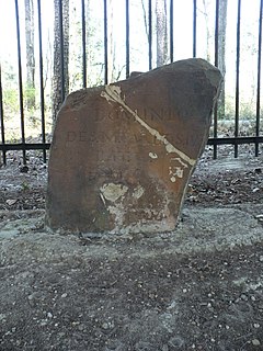
Ellicott's Stone, also known as the Ellicott Stone, is a boundary marker in northern Mobile County, Alabama. It was placed on April 10, 1799 by a joint U.S.-Spanish survey party headed by Andrew Ellicott. It was designated as a National Historic Civil Engineering Landmark in 1968 and was added to the National Register of Historic Places on April 11, 1973.

State Route 83, also or primarily known as Euclid Avenue, is a state highway and city street in the U.S. state of California. Officially, SR 83 runs from the Chino Valley Freeway in Chino Hills north to the San Bernardino Freeway in Upland. Euclid Avenue then continues north through Upland to the unincorporated community of San Antonio Heights.

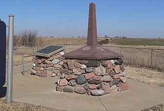
The San Bernardino meridian, established in 1852, is one of three principal meridians in the state of California. Because of the state's shape, three meridian–baseline sets are required for surveys in all parts of the state. The San Bernardino meridian is used for Southern California, and some townships in Arizona are also referenced to it.

San Bernardino Ranch is an historic ranch house in the southern San Bernardino Valley near the San Bernardino National Wildlife Refuge in extreme southeast Cochise County, Arizona, United States. It is significant for its association with the beginning of cattle ranching in southern Arizona and northern Mexico. The ranchland and valley are part of the headwaters region of the Yaqui River.

The Beginning Point of the U.S. Public Land Survey is the point from which the United States in 1786 began the formal survey of the lands known then as the Northwest Territory, now making up all or part of Ohio, Indiana, Illinois, Michigan, and Wisconsin. The survey is claimed to be the first major cadastral survey undertaken by any nation. The point now lies underwater on the state line between Ohio and Pennsylvania. Because it is submerged, a monument commemorating the point is adjacent to the nearest roadway and located on the state line between East Liverpool, Ohio and Ohioville, Pennsylvania. The area around the marker was designated a National Historic Landmark in 1965.

San Timoteo Canyon is a river valley canyon southeast of Redlands, in the far northwestern foothills of the San Jacinto Mountains in the Inland Empire region of Southern California.
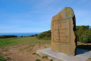
The San Francisco Bay Discovery Site is a marker commemorating the first recorded European sighting of San Francisco Bay. In 1769, the Portola expedition traveled north by land from San Diego, seeking to establish a base at the Port of Monterey described by Sebastian Vizcaino in 1602. When they reached Monterey, however, they were not sure it was the right place and decided to continue north. The party reached San Pedro Creek on October 31 and camped there for four nights, while scouts led by José Francisco Ortega climbed Sweeney Ridge, where they could see over the ridge toward the east, and so became the first Europeans to see San Francisco Bay on November 1.

Riverside County is a county located in the southern portion of the U.S. state of California. As of the 2010 census, the population was 2,189,641, making it the fourth-most populous county in California and the 10th-most populous in the United States. The name was derived from the city of Riverside, which is the county seat.
Agua Mansa is a former settlement in an unincorporated area of San Bernardino County, near Colton, California, United States. Once the largest settlement in San Bernardino County, it is now a ghost town. Only the cemetery remains.
The Brow Monument is a monument listed in the National Register of Historic Places for Coconino County, Arizona, located in the Kaibab National Forest. The site contains one of the few remaining survey markers used by the expedition of John Wesley Powell in 1872 It is accessible via the Brow Monument Trail.
The Yorba–Slaughter Adobe is a historic adobe house located at 17127 Pomona Rincon Road near Chino, California. Built in the early 1850s, the adobe is typical of the building style prevalent during and around California's period of Mexican governance. Raimundo Yorba built the adobe on land thought to be part of Rancho El Rincon, a land grant owned by his father, Bernardo Yorba; however, a later survey determined the adobe was not part of the rancho. The younger Yorba lived in the adobe until 1868, when Forty-Niner and Mexican–American War veteran Fenton M. Slaughter bought the house. Slaughter, who later served in the California State Assembly, lived in the house until his 1897 death.
Site No. JF00-072 is a survey monument located at the quadripoint of Republic and Washington counties in Kansas and Jefferson and Thayer counties in Nebraska. The monument marks the intersection of the sixth principal meridian and its baseline, the 40th parallel north; it serves as the initial point of all land surveys in Kansas and Nebraska, as well as most of Wyoming and Colorado, and part of South Dakota. The original sandstone monument was 6 feet (1.8 m) tall. U.S. Deputy Surveyor Charles A. Manners set the monument in 1856. The monument was later buried under a county roadbed; it was unearthed and reburied twice before being dug up for good in 1986, though its middle section is now missing.

The Redlands Central Railway Company car barn is a historic car barn located at 746 East Citrus Avenue in Redlands, California, United States. The building was used to house electric railway cars, first for the Redlands Central Railway and later for the Pacific Electric Railway. It is the only extant Pacific Electric car barn, and one of only two trolley barns remaining in Southern California.

The Santa Fe And Salt Lake Trail Monument was designated a California Historic Landmark (No.576) on May 17, 1957. Santa Fe And Salt Lake Trail Monument marks the place two Historic trail merged in Cajon Pass in San Bernardino County, California. The Old Spanish Trail and the Mohave Trail-Mojave Road merged in Cajon Pass. The large white marker is just off the Interstate 15 in Cajon Pass, was U.S. Route 66 in the past. It was built by the Pioneer Society of San Bernardino to remember and honor the pioneers that came west. The marker is 12 feet tall and 7 feet square at the base. Cajon Pass was home to the Serrano Indian, Native Californians that lived in the nearby Atongaibit village, in what is now Hesperia. In Summit Valley lived the Guapiabit, and in Cajon Canyon lived the Amuscopiabit. The pass was used by native in prehistory. The San Andreas Fault runs through and made the 3,777 ft (1,151 m) mountain pass between the San Bernardino Mountains and the San Gabriel Mountains in Southern California. One side in the Mojave Desert and the other the Los Angeles Basin. The Monument is specially dedicated to those that cross the pass on June 20, 1851 as part of the '49s. Sheldon Stoddard and Sydney P. Waite are two of the pioneers that crossed the pass in 1851. They were part of what is now called the Death Valley '49ers that crossed the pass after surviving a wrong detour though Death Valley in 1949. In addition to building the monument, the Pioneer Society of San Bernardino built a log cabin, picnic tables and benches in the mountains and San Bernardino for the public to use.

The Von Schmidt State Boundary Monument was designated a California Historic Landmark (No.859) on April 26, 1973. In 1873 San Francisco civil engineer Allexey W. Von Schmidt built the State Boundary Monument in San Bernardino County, California near Needles, California. In 1872 and 1873 Von Schmidt did a survey of the border between California and Nevada/Arizona. The California Historic marker is on the dirt road, Pew Road, also called River Road, 2.6 Miles South of the State Line; 14 Miles North of Needles. The marker is not at the current state boundary, as Von Schmidt made an error in his survey. A new survey in 1893 showed that the Von Schmidt line was 1,600 to 1,800 feet off to the west. The marker is at the southern end of the California-Arizona State boundary. In 1872, a dispute arose between Nevada and California about the location of the state's boundary. Nevada wanted the state divide to be the same as the Sierra Nevada mountain range divide. California wanted the line to the east of the mountain range. When California attained statehood in 1850, it adopted 120 degrees west longitude as its eastern border. Between 1855 and 1900 there were six surveys to locate 120 degrees, with each locating 120 degrees of longitude differently. Von Schmidt applied for and was granted the contract to survey the state's frontier border east of the Sierra Nevada. In 1872 Von Schmidt using only a compass, a sextant and dead reckoning process set out with his crew to define the boundary. Von Schmidt was charged to measure and mark the boundary. Von Schmidt and his crew built stone markers and installed cast iron markers about one mile apart on the length of the state's boundary. Not many of the markers had foundations, so fewer remain today. A new survey in 1893 showed that the Von Schmidt line was 1,600 to 1,800 feet west of the actual 120 degrees. However, California and Nevada both recognize the 1872 Von Schmidt survey and the 1893 survey as the state line. Later the 1893 line was used. The exact location of the north-south California-Nevada border, between Lake Tahoe and the intersection of the southern boundary of Oregon at the 42nd parallel, was contentious and was surveyed and re-surveyed many time. One of the few iron markers that has survived is a near Verdi, Nevada this is a National Historic Landmark called the 1872 California-Nevada State Boundary Marker.


