
Rock Creek Park is a large urban park that bisects the Northwest quadrant of Washington, D.C. Created by Act of Congress in 1890, the park comprises 1,754 acres, generally along Rock Creek, a tributary of the Potomac River.

Redlands is a city in San Bernardino County, California, United States. As of the 2020 census, the city had a population of 73,168, up from 68,747 at the 2010 census. The city is located approximately 45 miles (72 km) northwest of Palm Springs and 63 miles (101 km) east of Los Angeles.

The Great Falls of the Passaic River is a prominent waterfall, 77 feet (23 m) high, on the Passaic River in the city of Paterson in Passaic County, New Jersey. One of the United States' largest waterfalls, it played a significant role in the early industrial development of New Jersey starting in the earliest days of the nation. The falls and surrounding area are protected as part of the Paterson Great Falls National Historical Park, administered by the National Park Service. Congress authorized its establishment in 2009.

The Espada Acequia, or Piedras Creek Aqueduct, was built by Franciscan friars in 1731 in what is now San Antonio, Texas, United States. It was built to supply irrigation water to the lands near Mission San Francisco de la Espada, today part of San Antonio Missions National Historical Park. The acequia is still in use today and is an National Historic Civil Engineering Landmark and a National Historic Landmark.
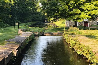
The Morris Canal (1829–1924) was a 107-mile (172 km) common carrier anthracite coal canal across northern New Jersey that connected the two industrial canals in Easton, Pennsylvania across the Delaware River from its western terminus at Phillipsburg, New Jersey to New York Harbor and New York City through its eastern terminals in Newark and on the Hudson River in Jersey City. The canal was sometimes called the Morris and Essex Canal, in error, due to confusion with the nearby and unrelated Morris and Essex Railroad.

The James River and Kanawha Canal was a partially built canal in Virginia intended to facilitate shipments of passengers and freight by water between the western counties of Virginia and the coast. Ultimately its towpath became the roadbed for a rail line following the same course.

The Dismal Swamp Canal is a canal located along the eastern edge of the Great Dismal Swamp in Virginia and North Carolina in the United States. Opened in 1805, it is the oldest continually operating man-made canal in the United States. It is part of the Intracoastal Waterway.

The Augusta Canal is a historic canal located in Augusta, Georgia, United States. The canal is fed by the Savannah River and passes through three levels in suburban and urban Augusta before the water returns to the river at various locations. It was devised to harness the water power at the fall line of the Savannah River to drive mills, to provide transportation of goods, and to provide a municipal water supply. It is the only canal in the US in continuous use for its original purposes of providing power, transport, and municipal water.
The Croton Aqueduct or Old Croton Aqueduct was a large and complex water distribution system constructed for New York City between 1837 and 1842. The great aqueducts, which were among the first in the United States, carried water by gravity 41 miles (66 km) from the Croton River in Westchester County to reservoirs in Manhattan. It was built because local water resources had become polluted and inadequate for the growing population of the city. Although the aqueduct was largely superseded by the New Croton Aqueduct, which was built in 1890, the Old Croton Aqueduct remained in service until 1955.

Ridley Creek State Park is a 2,606-acre (1,055 ha) Pennsylvania state park in Edgmont, Middletown, and Upper Providence Townships, Delaware County, Pennsylvania in the United States. The park, about 5 miles (8 km) north of the county seat of Media, offers many recreational activities, such as hiking, biking, fishing, and picnicking. Ridley Creek passes through the park. Highlights include a 5-mile (8 km) paved multi-use trail, a formal garden designed by the Olmsted Brothers, and Colonial Pennsylvania Plantation, which recreates daily life on a pre-Revolutionary farm. The park is adjacent to the John J. Tyler Arboretum. Ridley Creek State Park is just over 16 miles (26 km) from downtown, Philadelphia between Pennsylvania Route 352 and Pennsylvania Route 252 on Gradyville Road.

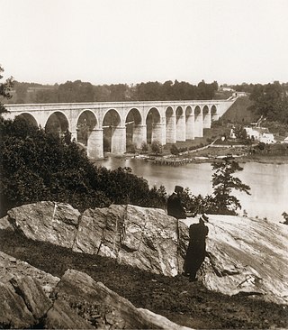
The Thomas Viaduct spans the Patapsco River and Patapsco Valley between Relay, Maryland and Elkridge, Maryland, USA. It was commissioned by the Baltimore and Ohio Railroad (B&O); built between July 4, 1833, and July 4, 1835; and named for Philip E. Thomas, the company's first president. Some claim it to be the world's oldest multiple arched stone railroad bridge. However, the Sankey Viaduct on the Liverpool and Manchester Railway was opened in 1830 and finally completed in 1833.

The Zanja Madre is the original aqueduct that brought water to the Pueblo de Los Angeles from the Río Porciúncula. The original open, earthen ditch, or zanja was completed by community laborers within a month of founding the pueblo. This water system was used for both domestic uses and irrigation to fields west of town. The main zanja ultimately fed eight branch zanjas. This availability of water was essential to the survival and growth of the community founded here. Brick conduits 3 to 3.5 feet in diameter were built to improve the system after 1884. Eventually the system did not supply enough water to keep pace with population growth and irrigation demand. The system was abandoned by 1904 though portions were still used for storm water purposes. It was maintained by the Zanjero of Los Angeles.

Mill Creek is a 17.8-mile-long (28.6 km) stream, originating in the San Bernardino Mountains, in San Bernardino County, California. It is a major tributary of the Santa Ana River. Their confluence occurs just downstream of the upper Santa Ana Canyon mouth. Part of the upper creek flows through San Bernardino National Forest, with the headwaters, being in the San Gorgonio Wilderness.
The Whitewater Canal, which was built between 1836 and 1847, spanned a distance of 76 miles (122 km) and stretched from Lawrenceburg, Indiana on the Ohio River to Hagerstown, Indiana near the West Fork of the White River.

Tinkers Creek Aqueduct is an aqueduct that was constructed to bridge the Ohio and Erie Canal over Tinkers Creek near its confluence with the Cuyahoga River in Valley View, Ohio. It is a relatively rare surviving example of an Ohio and Erie Canal aqueduct. It was originally constructed in 1825-1827 by, and re-built due to flood damage in 1845 and 1905. Tinkers Creek Aqueduct was included in a National Historic Landmark district established in 1966, and it was separately listed on the National Register of Historic Places in 1979. The original Tinkers Creek Aqueduct was a wood plank, steel truss, and Ashlar-sandstone structure constructed in 1827, south of the present aqueduct's location. Cuyahoga River and Tinkers Creek flooding caused continual damage to the original aqueduct, so successive structures were built in 1845 and 1905 in the present location. Today, Tinkers Creek Aqueduct is the only aqueduct which remains of the four original aqueducts in the Cuyahoga Valley. Of Furnace Run Aqueduct, Mill Creek Aqueduct, Peninsula Aqueduct, and Aqueduct; Mill Creek Aqueduct, of newer construction, is the only aqueduct which still carries Ohio and Erie Canal water. After 102 years of flooding, weathering, and deterioration, Tinkers Creek Aqueduct was removed in 2007. The National Park Service is currently working on Phase II of the project to reconstruct it from newer materials.

Crafton is an unincorporated community in San Bernardino County, California, United States, located east of Redlands, south of Mentone and west of Yucaipa, California.

Arthur De Wint Foote (1849–1933) was an American civil engineer and mining engineer who impacted the development of the American West with his innovative engineering works and entrepreneurial ventures. In Northern California in the late 1890s, he designed and built the North Star Mine Powerhouse, the highest capacity impulse-turbine power-plant of the time, and now a California historic landmark; within that plant he designed and installed the then-largest Pelton wheel turbine. Later, he designed and built Foote's Crossing, a high bridge, and Foote's Crossing Road, both now memorialized as California and U.S. landmarks.

The historical buildings and structures of Zion National Park represent a variety of buildings, interpretive structures, signs and infrastructure associated with the National Park Service's operations in Zion National Park, Utah. Structures vary in size and scale from the Zion Lodge to road culverts and curbs, nearly all of which were designed using native materials and regional construction techniques in an adapted version of the National Park Service Rustic style. A number of the larger structures were designed by Gilbert Stanley Underwood, while many of the smaller structures were designed or coordinated with the National Park Service Branch of Plans and Designs. The bulk of the historic structures date to the 1920s and 1930s. Most of the structures of the 1930s were built using Civilian Conservation Corps labor.

Little Sugar Creek Greenway is a linear park and stream restoration project in Mecklenburg County, North Carolina. When completed it will consist of twenty miles of trails and paved walkways running from Cordelia Park just north of uptown Charlotte, then south through midtown Charlotte, and continuing all the way to the South Carolina state line. The Little Sugar Creek Greenway is a key part of the Cross Charlotte Trail (XCLT) and a segment in the Carolina Thread Trail, a regionwide network of trails that pass through 15 counties.

Kaawchama, alternatively referred to as Wa’aachnga, was a significant Tongva village in the San Bernardino Valley located in what is now west Redlands, California. The village became referred to by the Spanish as the Guachama Rancheria in 1810 after a supply station was constructed at the village for Mission San Gabriel, which then became part of Rancho San Bernardino following the secularization of the missions in 1833.


