
Pipe Spring National Monument is a United States National Monument located in the U.S. state of Arizona, rich with American Indian, early explorer, and Mormon pioneer history. Administered by the National Park Service, Pipe Spring was listed on the National Register of Historic Places on October 15, 1966, and the boundaries of the Pipe Spring National Monument Historic District were expanded in October 2000.
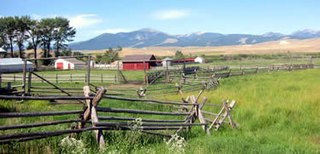
The Grant–Kohrs Ranch National Historic Site, created in 1972, commemorates the Western cattle industry from its 1850s inception through recent times. The original ranch was established in 1862 by a Canadian fur trader, Johnny Grant, at Cottonwood Creek, Montana, along the banks of the Clark Fork river. The ranch was later expanded by a cattle baron, Conrad Kohrs (1866–1920). The 1,618 acres (6.55 km2) historic site is maintained today as a working ranch by the National Park Service.

Kentucky Camp is a ghost town and former mining camp along the Arizona Trail in Pima County, Arizona, United States, near the community of Sonoita. The Kentucky Camp Historic District is listed on the National Register of Historic Places and has been since 1995. As it is located within Coronado National Forest, the United States Forest Service is responsible for the upkeep of the remaining buildings within the Kentucky Camp Historic District.
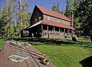
Drakesbad Guest Ranch, also known simply as Drakesbad, is a resort near Chester, California. It is located on Hot Springs Creek at the head of Warner Valley, inside Lassen Volcanic National Park.

White Oaks is a ghost town in Lincoln County, New Mexico, United States. Located on the outskirts of the Lincoln National Forest, it became a boomtown in 1879 following the discovery of gold and coal in the nearby Jicarilla Mountains.

Joshua Tree National Park is a national park of the United States in southeastern California, east of San Bernardino and Los Angeles and north of Palm Springs. It is named after the Joshua trees native to the Mojave Desert. Originally declared a national monument in 1936, Joshua Tree was redesignated as a national park in 1994 when the U.S. Congress passed the California Desert Protection Act. Encompassing a total of 795,156 acres – slightly larger than the state of Rhode Island – the park includes 429,690 acres of designated wilderness. Straddling San Bernardino and Riverside Counties, the park includes parts of two deserts, each an ecosystem whose characteristics are determined primarily by elevation: the higher Mojave Desert and the lower Colorado Desert. The Little San Bernardino Mountains traverse the southwest edge of the park.

The Desert Queen Mine in the Colorado Desert was one of the more long-lived gold mines of Southern California's high desert region. The abandoned mine is located in Riverside County, California within the boundaries of the Joshua Tree National Park and is included on the National Register of Historic Places. A hiking trail leads to the mine.

The Keys Ranch is the prime example of early settlement in the Joshua Tree National Park area. Bill Keys was the area's leading character, and his ranch is a symbol of the resourcefulness of early settlers. The ranch is an extensive complex of small frame buildings built between 1910 and Keys' death in 1964. Keys pursued both ranching and mining to make a living in the desert.
The Wall Street Mill in Joshua Tree National Park was a complete and operable gold ore crushing mill featuring late-19th century two-stamp mill machinery. Consequently, the significance encompasses the mill machinery, the building which houses it, the well which supplied water for the mill's operation, and the well pump. It is the only gold ore crushing mill in the region that retains integrity.
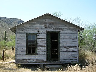
The Bates Well Ranch, also known as the Bates Well, Growler Well, Gray Ranch and El Veit, was one of the fifteen ranches and line camps in the Gray family cattle business in the Sonoran Desert country north of the US-Mexico border in Pima County, Arizona. Operating for nearly 60 years, the ranch is now part of Organ Pipe Cactus National Monument.

The Dos Lomitas Ranch, also known as the Rattlesnake Ranch, Blankenship Well and the Gray Ranch, was the first of fifteen ranches and line camps in the Gray family cattle business in the Sonoran Desert country north of the US-Mexico border in Arizona. The ranch is now part of Organ Pipe Cactus National Monument. The period of significance begins for the district with the purchase of the water rights for the ranch in 1919 and ends with the death with the last of the three Gray sons, Robert, Jr., in 1976, and the subsequent removal of the last of the Gray's cattle from the monument.

The McGraw Ranch, also known as the Indian Head Ranch, the =Y Ranch and the =X Ranch, was established in the Cow Creek valley near Estes Park, Colorado by Peter J. Pauley, Jr., who built a barn at his 160-acre (0.65 km2) =Y Ranch in 1884, running 2500 head of cattle on the land. The land was sold in 1897 to Hugo S. Miller, who worked with Henry C. Rouse to expand the property to a thousand acres (4 km²). In 1907 Miller and his wife inherited the lands from Rouse and were visited by Joh J. and Irene McGraw, who leased the property the next summer and purchased it in 1909, changing the brand to =X.

The P Ranch is a historic ranch in Harney County in southeastern Oregon, United States. The remaining ranch structures are located on the west bank of the Donner und Blitzen River in the Malheur National Wildlife Refuge. The ranch was built by Peter French, a well known 19th-century cattle baron. The P Ranch became headquarters for the French-Glenn Livestock Company, which eventually covered over 140,000 acres (570 km2). After French was murdered in 1897, the French-Glenn Livestock Company slowly sold off the P Ranch property. In 1935, the United States Government purchased the remaining P Ranch property to add to an adjacent wildlife refuge. The Civilian Conservation Corps demolished most of the original ranch buildings in the 1930s, and a fire destroyed the main ranch house in 1947. The few remaining P Ranch structures are now listed on the National Register of Historic Places.

The Sod House Ranch is a historic ranch in Harney County in southeastern Oregon, United States. The remaining ranch structures are located south of Malheur Lake in the Malheur National Wildlife Refuge. The ranch was built by Peter French, a well known 19th-century cattle baron. The Sod House Ranch became the headquarters for the northern operating division of the French-Glenn Livestock Company, which eventually covered over 140,000 acres (570 km2). After French was murdered in 1897, the French-Glenn Livestock Company slowly sold off its ranch property. In 1935, the United States Government purchased the Sod House Ranch property to add to an adjacent wildlife refuge. The eight remaining Sod House Ranch buildings are now listed on the National Register of Historic Places.

The David L. Shirk Ranch is a historic ranch located in the Guano Valley of eastern Lake County, Oregon, United States. The ranch was originally homesteaded in 1881. It was purchased by David L. Shirk in 1883. He operated the ranch until 1914. The property was acquired by the United States Government in 1942. The ranch is now administered by the Bureau of Land Management. The remaining historic ranch buildings are listed on the National Register of Historic Places.

The historical buildings and structures of Grand Teton National Park include a variety of buildings and built remains that pre-date the establishment of Grand Teton National Park, together with facilities built by the National Park Service to serve park visitors. Many of these places and structures have been placed on the National Register of Historic Places. The pre-Park Service structures include homestead cabins from the earliest settlement of Jackson Hole, working ranches that once covered the valley floor, and dude ranches or guest ranches that catered to the tourist trade that grew up in the 1920s and 1930s, before the park was expanded to encompass nearly all of Jackson Hole. Many of these were incorporated into the park to serve as Park Service personnel housing, or were razed to restore the landscape to a natural appearance. Others continued to function as inholdings under a life estate in which their former owners could continue to use and occupy the property until their death. Other buildings, built in the mountains after the initial establishment of the park in 1929, or in the valley after the park was expanded in 1950, were built by the Park Service to serve park visitors, frequently employing the National Park Service Rustic style of design.
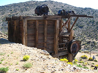
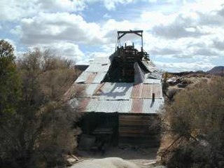
Lost Horse Mine is a historic gold and silver mine in the Lost Horse Valley of Joshua Tree National Park. Between 1894 and 1931, it produced 10,000 ounces of gold and 16,000 ounces of silver. It was first developed by Johnny Lang, then by J.D. Ryan. Scarce resources for steam powered pumps and mining equipment, led to denuding the local mountains of trees, which is still clearly visible in 2014.

