El Castillo de Monterey

Last updated

El Castillo de Monterey
El Castillo
El Castillo site.jpg
El Castillo site
Location map Monterey Peninsula.png
Red pog.svg
USA California location map.svg
Red pog.svg
Location Monterey, California
Coordinates 36°36′22″N121°53′43″W / 36.60611°N 121.89528°W / 36.60611; -121.89528
Built1792;232 years ago (1792)
NRHP reference No. 71000167 [1]
Added to NRHPNovember 23, 1971

El Castillo de Monterey (Spanish for "The Castle of Monterey") was a fortification in Monterey, California, founded in 1792 by the Spanish Empire. The fort was constructed to protect the Monterey port and the Presidio of Monterey from invaders. [2] The site was officially listed on the National Register of Historic Places on November 23, 1971.

Contents

History

Spanish period (1770–1821)

Recognizing the significance of Monterey Bay, the Spanish sought to establish a firm presence in Alta California. The fort, initiated in 1792, started as a rudimentary log parapet with seven mounted and four unmounted cannons positioned behind it, aiming to safeguard the nearby Presidio of Monterey. Positioned on present-day Presidio Hill, the site sits on a level plain at an elevation of 60 ft (18 m), with views of the Monterey Harbor. [2] [3]

By 1796, enhancements were made to the Castillo, strengthening it with the addition of a new 60 ft (18 m) earthen V-shape embankment, 4 ft (1.2 m) high, on the side facing the Monterey Bay. The upgrades comprised a wooden gun platform supported by adobe bricks, casemates, and a barracks for the artillerymen. Despite these improvements, the Castillo did not attain sufficient fortification, and people visiting the area commonly criticized its capabilities. [2] [4]

The initial trial for the Castillo occurred on November 20, 1818, when two Argentine pirate ships, led by Commander Hippolyte Bouchard, launched an assault on Monterey. The pirates were unsuccessful in a frontal assault on the town and opted to disembark a command on Point Pinos. From there, they initiated their first attack on the Castillo, overpowering the defenders. Subsequently, they redirected the cannons towards the town, launching an assault that overwhelmed the defenders, prompting them to flee. The pirates went on to ransack the town, demolishing the Castillo's cannons and buildings. Before departing, they set the town on fire. [2] [3] [4]

Mexican period (1822–1846)

Mexico gained independence from Spain in 1821. On November 3, 1836, Jose Castro, alongside a coalition of disgruntled ranchers, Indigenous people, and Americans, successfully captured the Castillo. The cannons were once again directed towards the town, compelling Governor Nicolás Gutiérrez to surrender after a single cannon shot. [4] [2]

On October 19, 1842, Commodore Thomas Catesby Jones of the United States Navy erroneously thought that the United States and Mexico were at war, leading him to take control of the fort on October 20, 1842. After realizing his mistake, Jones offered an apology and reinstated Mexican rule. [3] [4] [2]

American period (1846–present)

Batalla de Monterey Batalla de Monterey.jpg
Batalla de Monterey
The U.S. Capture of Monterey by Commodore Sloat The U.S. Capture of Monterey by Commodore Sloat.jpg
The U.S. Capture of Monterey by Commodore Sloat

The U.S. Congress proclaimed the Mexican–American War on May 11, 1846, following a Mexican assault on U.S. forces in Texas. This declaration paved the way for the American occupation of California. The commencement of the American period occurred in Monterey, marked by the entry of U.S. naval ships into Monterey Bay. While in command of the Savannah, Navy Captain William Mervine led a detachment of sailors and United States Marines against Monterey, California. [3] [4]

Early on July 7, 1846, the frigate USS Savannah and the two sloops, USS Cyane and USS Levant of the United States Navy, commanded by Commodore John D. Sloat, engaged in a skirmish called the Battle of Monterey. Sloat raised the American flag atop the Customs House at Monterey, and issued a proclamation announcing that California was now part of the United States. [5] [3]

Recognizing the susceptibility of old El Castillo site to land attacks from the raised ground behind it, the U.S. troops opted not to utilize it for their gun batteries. Instead, they built the initial U.S. fortification, Fort Mervine, on Presidio Hill behind the old Castillo. [3] Little was left of El Castillo by 1880. In 1967, via National Park Service, a team of archaeologists, led by William E. Pritchard, was employed by the Central California Archaeological Foundation to conduct the excavation. the archeological excavations found stone foundations, two gun platforms, several stone storerooms and an adobe wall. [2] [4]

In 1934, the site was declared a California Historical Landmark. In 1970, it was included on the National Register of Historic Places. A historical marker reads: "Site of Spanish fort constructed in 1792 to protect the port and presidio of Monterey from inverse. This is one of only three forts constructed by the Spanish in California." [4]

See also

Related Research Articles

<span class="mw-page-title-main">Presidio of San Francisco</span> Place in California, United States

The Presidio of San Francisco is a park and former U.S. Army post on the northern tip of the San Francisco Peninsula in San Francisco, California, and is part of the Golden Gate National Recreation Area.

<span class="mw-page-title-main">John D. Sloat</span> Military Governor of California

John Drake Sloat was a commodore in the United States Navy who, in 1846, claimed California for the United States.

<span class="mw-page-title-main">Battle of Monterey</span>

The Battle of Monterey, at Monterey, California, occurred on 7 July 1846, during the Mexican–American War. The United States captured the town unopposed.

<span class="mw-page-title-main">Mariano Guadalupe Vallejo</span> Early State of California politician (1807–1890)

Don Mariano Guadalupe Vallejo was a Californio general, statesman, and public figure. He was born a subject of Spain, performed his military duties as an officer of the Republic of Mexico, and shaped the transition of Alta California from a territory of Mexico to the U.S. state of California. He served in the first session of the California State Senate. The city of Vallejo, California, is named after him, and the nearby city of Benicia is named after his wife.

<span class="mw-page-title-main">Presidio</span> Fort type

A presidio was a fortified base established by the Spanish Empire between the 16th and 18th centuries in areas under their control or influence. The term is derived from the Latin word praesidium meaning protection or defense.

<span class="mw-page-title-main">Castillo San Felipe del Morro</span> 16th-century fortress and citadel in Puerto Rico

Castillo San Felipe del Morro, most commonly known as El Morro(The Promontory), is a large fortress and citadel in the historic district of Old San Juan in Puerto Rico. Commissioned by King Charles I of Spain in 1539, it was first built as a fortified tower in honor of King Philip II, who oversaw its expansion into a hornwork fort by 1595. Over the next 200 years, especially in the reign of King Charles III, El Morro continued to be developed to reach its current form in 1787. Rising 140 ft from the Atlantic shoreline with 18 to 25 ft thick walls, the six-leveled edifice stands on a steep, rocky headland promontory on San Juan Islet guarding the entry to San Juan Bay, the harbor of Old San Juan. El Morro, alongside La Fortaleza, San Cristóbal, El Cañuelo, and other forts part of the Walls of Old San Juan, protected strategically and militarily important Puerto Rico, or La Llave de las Indias, from invasion by competing world powers during the Age of Sail. It was designated a World Heritage Site by UNESCO in 1983.

<span class="mw-page-title-main">Fort Point National Historic Site</span> Fort in San Francisco, California

Fort Point, known historically as the Castillo de San Joaquín is a masonry seacoast fortification located on the southern side of the Golden Gate at the entrance to San Francisco Bay. It is also the geographic name of the promontory upon which the fort and the southern approach of the Golden Gate Bridge were constructed.

<span class="mw-page-title-main">Presidio of Monterey, California</span> US Army military base

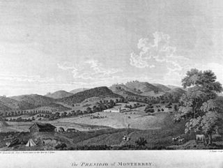
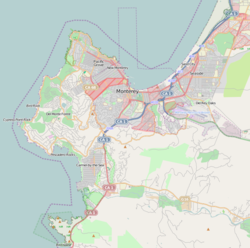
The Presidio of Monterey (POM), located in Monterey, California, is an active US Army installation with historic ties to the Spanish colonial era. Currently, it is the home of the Defense Language Institute Foreign Language Center (DLI-FLC). It is the last and only presidio in California to have an active military installation.

USS <i>Cyane</i> (1837) Sloops-of-war of the United States Navy

The second USS Cyane was a sloop-of-war in the United States Navy during the Mexican–American War.

<span class="mw-page-title-main">Presidio of Santa Barbara</span> United States historic place

El Presidio Real de Santa Bárbara, also known as the Royal Presidio of Santa Barbara, is a former military installation in Santa Barbara, California, United States. The presidio was built by Spain in 1782, with the mission of defending the Second Military District in California. In modern times, the Presidio serves as a significant tourist attraction, museum and an active archaeological site as part of El Presidio de Santa Barbara State Historic Park.

<span class="mw-page-title-main">Archibald H. Gillespie</span>

Major Archibald H. Gillespie was an officer in the United States Marine Corps during the Mexican–American War.

The Forts of Texas include a number of historical and operational military installations. For over 200 years, various groups fought over access to or control over the region that is now Texas. Possession of the region was claimed and disputed by the European powers of Spain and France, and the continental countries of Mexico, the United States, the Republic of Texas, and the Confederate States of America. Ownership of specific lands was claimed and disputed by different ethnic groups, including numerous Native American tribes, Mexican residents, Anglo- and African-American settlers, and European immigrants. Access to and control of resources were claimed and disputed by various economic groups, including indigenous hunter/gatherers, farmers, herders, ranchers, colonists, settlers, buffalo hunters, traders, bandits, smugglers, pirates, and revolutionaries. Over the centuries, claims and disputes were enforced by Native American warriors, Spanish conquistadors, French cavaliers, Texas Rangers, local militias, and uniformed regular army regiments of Spain, Mexico, Texas, the United States, and the Confederacy.

<span class="mw-page-title-main">Yerba Buena, California</span> Original name of the Spanish settlement which became San Francisco, California, US

Yerba Buena was the original name of the settlement that later became San Francisco. Located near the northeastern end of the San Francisco Peninsula, between the Presidio of San Francisco and the Mission San Francisco de Asís, it was originally intended as a trading post for ships visiting San Francisco Bay. The settlement was arranged in the Spanish style around a plaza that remains as the present day Portsmouth Square.

<span class="mw-page-title-main">Fort Guijarros</span> Historic site in San Diego, California

Fort Guijarros was a Spanish fort in what is now San Diego, California, United States. Its name means "Fort Cobblestones" in English. It was built in 1797 on Ballast Point as the first defensive fortifications for San Diego Bay. It was involved in the Battle of San Diego, a naval battle between the fort and an American trading vessel. The site is registered as California Historical Landmark #69.

<span class="mw-page-title-main">Old Custom House (Monterey, California)</span> United States historic place

The Old Custom House is the oldest surviving government building in California, built in 1827 by Mexican authorities in Monterey, then the capital of Alta California. The former custom house is the first designated California Historical Landmark, marking the site where U.S. Commodore John Drake Sloat raised the American flag and declared California part of the United States in 1846 during the American Conquest of California.

<span class="mw-page-title-main">Architecture of San Francisco</span>

The architecture of San Francisco is not so much known for defining a particular architectural style; rather, with its interesting and challenging variations in geography and topology and tumultuous history, San Francisco is known worldwide for its particularly eclectic mix of Victorian and modern architecture. Bay windows were identified as a defining characteristic of San Francisco architecture in a 2012 study that had a machine learning algorithm examine a random sample of 25,000 photos of cities from Google Street View.

<span class="mw-page-title-main">Presidio San Ignacio de Tubac</span> Historic former fort in southern Arizona

The Presidio of San Ignacio de Túbac or Fort Tubac was a Spanish built fortress. The fortification was established by the Spanish Army in 1752 at the site of present-day Tubac, Arizona. Its ruins are preserved in the Tubac Presidio State Historic Park.

<span class="mw-page-title-main">Sonoma Barracks</span> 19th century adobe barracks in California

The Sonoma Barracks is a two-story, wide-balconied, adobe building facing the central plaza of the City of Sonoma, California. It was built by order of Mariano Guadalupe Vallejo to house the Mexican soldiers that had been transferred from the Presidio of San Francisco in 1835. The Presidio Company and their commander, Vallejo, were also responsible for controlling the Native Americans living on the northern border of Mexican California.

<span class="mw-page-title-main">Murphy's Corral</span> Historical Landmark in Elk Grove, United States

Murphy's Ranch, also called Murphy's Corral, is a historical site in Elk Grove, Sacramento County, California. The site of Murphy's Ranch is a California Historical Landmark No. 680 listed on May 11, 1959. At Murphy's Ranch on June 10, 1846, was the start of the Bear Flag Revolt and Bear Flag Rebellion.

<span class="mw-page-title-main">Fort Stockton (San Diego, California)</span> Historical Landmark in San Diego, California, United States

Fort Stockton, later called Fort Dupont, was a historical fortress in San Diego, California, built in 1828. The Fort Stockton site is a California Historical Landmark No. 54, listed on December 6, 1932.

References

  1. "National Register Information System". National Register of Historic Places . National Park Service. July 9, 2010.
  2. 1 2 3 4 5 6 7 Spencer-Hancock, Diane; Pritchard, William E. (1922). California Historical Society quarterly. California Historical Society. pp. 230–231. Retrieved February 20, 2024.
  3. 1 2 3 4 5 6 Roberts, Robert B (1988). Encyclopedia of historic forts : the military, pioneer, and trading posts of the United States. Macmillan. pp. 78–79. ISBN   978-0-02-926880-3 . Retrieved February 22, 2024.
  4. 1 2 3 4 5 6 7 Justin Ruhge. "Historic California Posts, Camps, Stations and Airfields Castillo de Monterey". www.militarymuseum.org. Retrieved February 22, 2024.
  5. Ruhge, Justin (February 8, 2016). "The Mexican War and California: Monterey's Presidio Occupied and Improved". militarymuseum.org.