Bay Farm Island Bridge

Last updated
Bay Farm Island Bridge
Aerial view of Bay Farm Island Bridge in 2009.jpg
Aerial view of both bridges (2009)
Coordinates 37°44′56″N122°14′11″W / 37.748924°N 122.236383°W / 37.748924; -122.236383 Coordinates: 37°44′56″N122°14′11″W / 37.748924°N 122.236383°W / 37.748924; -122.236383
Carriescars and trucks on California 61.svg SR 61
CrossesSan Leandro Channel, leading to San Leandro Bay
Locale San Francisco Bay Area
Official nameSan Leandro Bay Bridge
NBI33 0086
Characteristics
Design Bascule truss
MaterialSteel, concrete
Total length963 ft 6 in (293.67 m)
Width70 ft 6 in (21.49 m) overall
26 ft (7.9 m) roadway
5 ft (1.5 m) sidewalk
Longest span125 ft (38 m) bascule
Clearance below 20 ft (6.1 m) (high tide)
26 ft (7.9 m) (low tide)
History
Constructed byDuncason-Harleson and Stolte
Construction startApril 18, 1951 (1951-04-18)
OpenedJuly 1, 1953 (1953-07-01)
Statistics
Daily traffic 40,000
Location
Bay Farm Island Bridge
Bay Farm Island Bicycle Bridge
Pedestrian Draw Bridge (5167333).jpg
View along bicycle bridge
Coordinates 37°44′56.5″N122°14′9.3″W / 37.749028°N 122.235917°W / 37.749028; -122.235917
Carriesbicycles and pedestrians on San Francisco Bay Trail
Official nameSan Leandro Bay Bike Bridge
Characteristics
Design Bascule, pony Warren truss
MaterialSteel, concrete
Total length750 ft (230 m)
Width14 ft (4.3 m) overall
11 ft (3.4 m) curb-to-curb
Longest span130 feet (40 m) bascule
Clearance below 20 ft (6.1 m) (high tide)
26 ft (7.9 m) (low tide)
History
Construction start1993
Opened1995
Location
Bay Farm Island Bridge

The San Leandro Bay Bridge, better known as the Bay Farm Island Bridge, is a single-leaf bascule drawbridge spanning the San Leandro Channel, the inlet of San Leandro Bay within the San Francisco Bay Area, California, United States. It carries California State Route 61 and links the main island of Alameda with Bay Farm Island within the city of Alameda. The present bridge was completed in 1953; it is paralleled by a second bridge (completed in 1995) devoted to pedestrian and bicycle traffic, the Bay Farm Island Bicycle Bridge.

Contents

The Bay Farm Island Bridge is one of the four bridges and two tunnels linking Alameda Island with the mainland. It is the longest bridge of the four.

History

A toll bridge at this location was first built in 1854, consisting of a wooden trestle surfaced with crushed oyster shells. The owners abandoned the bridge after a failed business deal for land on Bay Farm Island, and the 1854 bridge subsequently rotted. Alameda County constructed a second bridge in 1875. [1] [2] In 1877 the bridge was described as a drawbridge with an overall length of 700 feet (210 m). [3] The second bridge had been repaired in 1890, [4] and was replaced by a third bridge in 1898. [1] Parts of the third bridge had initially been built in 1881 to span the Oakland Estuary at Webster Street, and were moved to span the San Leandro Channel in 1898; [5] the third bridge was a swing-type bridge. [2] By 1904, it was described as a "creaking old bridge", [6] and by 1912, the bridge had "settled dangerously" and "needed immediate repairs." [7]

In 1899, Mr. Gighilone, a vegetable farmer from Bay Farm Island, was ambushed by customs officers while crossing the bridge. The customs officers believed he was in league with opium smugglers who supposedly had their headquarters on Bay Farm Island; the smugglers purportedly used vegetable peddlers to smuggle opium across the bridge to Alameda, where it would be taken to San Francisco for distribution. When Gighilone was commanded to stop, he thought he was being robbed and attempted to escape until several bullets convinced him to stop. [8]

The fourth bridge, completed in 1953 and opened for service on July 1 of that year, was constructed by the California Department of Transportation (CalTrans) as part of California State Route 61. It is owned and maintained by CalTrans, District 4. [1] The total cost of the 1953 bridge, including right-of-way acquisition, approach structures, engineering, design, and construction, was US$2,344,000(equivalent to $23,740,000 in 2021). [5]

The bicycle bridge was constructed between 1993 and 1995 at a cost of approximately US$3,500,000(equivalent to $6,220,000 in 2021). [9]

In late 2015 and early 2016, the road and bicycle bridges were temporarily closed at night to accommodate maintenance activities, including repainting the road bridge. It had last been painted in 1978. [10]

Design

The 1953 road bridge is the longest bascule bridge in Alameda County by overall length. [1] It was designed to accommodate a future second leaf, if warranted by marine traffic, to double the navigable channel width from 92 feet (28 m) to 200 feet (61 m). [5] The existing leaf is opened by two 50-horsepower (37 kW) motors in approximately 135 seconds. [5] The bridge was designed by the California Division of Highways, Bridge Department. [5]

The main pier of the 1953 road bridge is the largest cofferdam built on a state highway since the construction of the San Francisco–Oakland Bay Bridge. [5] The bascule span is 125 feet (38 m) long and carries a counterweight of 1,100 short tons (1,000 t). [5] Interlocks are provided so that traffic gates and bollards must be raised before the draw can be opened. [5]

The 1995 bicycle bridge is linked to the 1953 road bridge so that when the road bridge opens, the bicycle bridge also opens; however, the bicycle bridge can be operated manually to open independently of the road bridge. [9] The bicycle bridge is operated using two hydraulic pistons and two 50-horsepower (37 kW) motors; the other drawbridges linking Alameda to the mainland operate using gearboxes and gears. [9] It is the only pedestrian bascule bridge in the United States. [11] [12]

Related Research Articles

<span class="mw-page-title-main">Alameda, California</span> Incorporated city in the state of California, United States

Alameda is a city in Alameda County, California, located in the East Bay region of the Bay Area. The city is primarily located on Alameda Island, but also spans Bay Farm Island and Coast Guard Island, as well as a few other smaller islands in San Francisco Bay. The city's estimated population in 2019 was 77,624.

<span class="mw-page-title-main">Dumbarton Bridge (California)</span> Southernmost bridge crossing the San Francisco Bay

The Dumbarton Bridge is the southernmost of the highway bridges across San Francisco Bay in California. Carrying over 70,000 vehicles and about 118 pedestrian and bicycle crossings daily, it is the shortest bridge across San Francisco Bay at 1.63 miles. Its eastern end is in Fremont, near Newark in the San Francisco Bay National Wildlife Refuge, and its western end is in Menlo Park. Bridging State Route 84 across the bay, it has three lanes each way and a separated bike/pedestrian lane along its south side. Like the San Mateo Bridge to the north, power lines parallel the bridge.

<span class="mw-page-title-main">San Francisco–Oakland Bay Bridge</span> Complex of bridges spanning San Francisco Bay

The San Francisco–Oakland Bay Bridge, known locally as the Bay Bridge, is a complex of bridges spanning San Francisco Bay in California. As part of Interstate 80 and the direct road between San Francisco and Oakland, it carries about 260,000 vehicles a day on its two decks. It has one of the longest spans in the United States.

<span class="mw-page-title-main">Richmond–San Rafael Bridge</span> Bridge crossing the San Francisco Bay

The Richmond–San Rafael Bridge is the northernmost of the east–west crossings of the San Francisco Bay in California, USA. Officially named after California State Senator John F. McCarthy, it bridges Interstate 580 from Richmond on the east to San Rafael on the west. It opened in 1956, replacing ferry service by the Richmond–San Rafael Ferry Company.

<span class="mw-page-title-main">Moveable bridge</span>

A moveable bridge, or movable bridge, is a bridge that moves to allow passage for boats or barges. In American English, the term is synonymous with drawbridge, and the latter is the common term, but drawbridge can be limited to the narrower, historical definition used in some other forms of English, in which drawbridge refers to only a specific type of moveable bridge often found in castles.

<span class="mw-page-title-main">California State Route 61</span> Highway in California

State Route 61 is a state highway in the U.S. state of California, running along the eastern edge of Oakland International Airport and through Alameda. Two additional "hidden" state highways, State Route 112 and State Route 260, are also signed as part of SR 61, despite having legal descriptions separate from Route 61.

<span class="mw-page-title-main">San Francisco Bay Trail</span> Bicycle and pedestrian trail

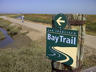
The San Francisco Bay Trail is a bicycle and pedestrian trail that when finished will allow continuous travel around the shoreline of San Francisco Bay. As of 2020, 356 miles (573 km) of the trail have been completed. When finished, the trail will be over 500 miles (800 km) of paved and gravel paths, bike lanes, and sidewalks, linking 47 cities across nine counties and crossing seven toll bridges. It is a project of the Association of Bay Area Governments (ABAG) and the Metropolitan Transportation Commission (MTC), in collaboration with other agencies, private companies, non-profit organizations, and advocacy groups.

<span class="mw-page-title-main">Transportation in the San Francisco Bay Area</span> Overview of transportation in the San Francisco Bay Area, California, United States

People in the San Francisco Bay Area rely on a complex multimodal transportation infrastructure consisting of roads, bridges, highways, rail, tunnels, airports, seaports, and bike and pedestrian paths. The development, maintenance, and operation of these different modes of transportation are overseen by various agencies, including the California Department of Transportation (Caltrans), the Association of Bay Area Governments, San Francisco Municipal Transportation Agency, and the Metropolitan Transportation Commission. These and other organizations collectively manage several interstate highways and state routes, two subway networks, two commuter rail agencies, eight trans-bay bridges, transbay ferry service, local bus service, three international airports, and an extensive network of roads, tunnels, and bike paths.

<span class="mw-page-title-main">Washington Bridge (Providence, Rhode Island)</span> Bridge in Between Providence and East Providence, Rhode Island

The Washington Bridge is a series of three bridges carrying Interstate 195, US Route 6, US Route 44, and U.S. Route 1A over the Seekonk River connecting India Point in Providence to Watchemoket Square in East Providence, Rhode Island. The historic portion of the bridge dating to 1930 serves as the pedestrian crossing, and bike link to the East Bay Bike Path. The pedestrian span is also a part of the Washington-Rochambeau National Historic Trail.

<span class="mw-page-title-main">Bay Farm Island, Alameda, California</span>

Bay Farm Island is a district of the city of Alameda, California, though it is separated from the rest of the city on Alameda Island by an estuary of San Leandro Bay. Its ZIP code is 94502. The location was originally an island in San Francisco Bay, but due to land reclamation it has become a peninsula and is now connected to the mainland of Oakland and Oakland International Airport. Marshes and other areas of the island were also reclaimed.

<span class="mw-page-title-main">Commodore Schuyler F. Heim Bridge</span> Bridge in Wilmington, California

The Commodore Schuyler F. Heim Bridge was a vertical-lift bridge in the Port of Los Angeles. Dedicated on January 10, 1948, the bridge allowed State Route 47 to cross over the Cerritos Channel. Named after Schuyler F. Heim, who was in command of the Naval Air Station on Terminal Island in 1942, the bridge was one of the largest vertical-lift bridges on the West Coast. At the time of its opening, it was the highest in the country with the deck weighing about 820 short tons. Its towers are 186 feet (57 m) tall above the roadway deck and about 236 feet (72 m) tall when measured from the water level at high water. The bridge was decommissioned on October 12, 2015 and replaced by a new, six-lane fixed-span bridge in order to meet current safety and earthquake standards. A replacement bridge, tentatively titled State Route 47 Schuyler Heim Bridge Replacement, was completed in September 2020.

The Posey and Webster Street Tubes are two parallel underwater tunnels connecting the cities of Oakland and Alameda, California, running beneath the Oakland Estuary. Both are immersed tubes, constructed by sinking precast concrete segments to a trench in the Estuary floor, then sealing them together to create a tunnel. The Posey Tube, completed in 1928, currently carries one-way (Oakland-bound) traffic under the Estuary, while the Webster Street Tube, completed in 1963, carries traffic from Oakland to Alameda.

<span class="mw-page-title-main">Park Street Bridge</span> Bridge in San Francisco Bay Area

The Park Street Bridge is a double-leaf bascule drawbridge spanning 372 feet of the Oakland Estuary in the San Francisco Bay Area. It links the cities of Oakland and Alameda. In a year, the bridge is opened approximately 1700 times and carries approximately 40,000 vehicles per work day. It was built when the Oakland Estuary was trenched, converting Alameda from a peninsula to an island.

<span class="mw-page-title-main">Fruitvale Bridge</span> Bridge between Alameda and Oakland, California, U.S.

The Fruitvale Bridge and the Fruitvale Avenue Bridge are parallel bridges that cross the Oakland Estuary, linking the cities of Oakland and Alameda in California. The Fruitvale Bridge is a vertical-lift Warren through truss railroad moveable bridge, while the Fruitvale Avenue Bridge is a steel stringer road bascule bridge that connects Fruitvale Avenue in Oakland with Tilden Way in Alameda.

<span class="mw-page-title-main">Galveston Causeway</span> Bridge in Texas, United States

The George and Cynthia Mitchell Memorial Causeway is a set of causeways in Galveston, Texas, United States. Two of the routes carry the southbound and northbound traffic of Interstate 45, while the original causeway is restricted to rail traffic. It is the main roadway access point to Galveston Island. The second access point is Bolivar Ferry.

<span class="mw-page-title-main">Smith Point Bridge</span> Bridge in New York, USA

The Smith Point Bridge is a steel bascule drawbridge in Shirley, New York that connects Long Island to Fire Island. Located on the south shore of central Suffolk County, the bridge carries William Floyd Parkway across The Narrows between Bellport Bay and Moriches Bay. It connects Long Island with Smith Point County Park and the Otis Pike Fire Island High Dune Wilderness, both are a part of the Fire Island National Seashore.

<span class="mw-page-title-main">Bike East Bay</span>

Bike East Bay, formerly known as East Bay Bicycle Coalition, is a Californian non-profit organization that worked since 1972 toward "promoting bicycling as an everyday means of transportation and recreation" in Alameda and Contra Costa counties of the California's East Bay. As a tax-exempt 501(c)3 grassroots bicycle advocacy organization, Bike East Bay endeavors to broaden awareness of bicycling with local, regional, and state government agencies and their staff, as well as elected officials, and the general public they represent.

<span class="mw-page-title-main">Southern Crossing (California)</span> Proposed fixed link across the San Francisco Bay

The Southern Crossing is a proposed highway structure that would span San Francisco Bay in California, somewhere south of the San Francisco–Oakland Bay Bridge and north of the San Mateo–Hayward Bridge. Several proposals have been made since 1947, varying in design and specific location, but none of them have ever been implemented because of cost, environmental and other concerns.

<span class="mw-page-title-main">High Street Bridge</span> Bridge in San Francisco Bay Area

The High Street Bridge is a double-leaf bascule drawbridge spanning 296 feet of the Oakland Estuary in the San Francisco Bay Area, California, United States. It links the cities of Oakland and Alameda. The bridge is opened approximately 1,400 times a year. The bridge carries an average of 26,000 vehicles per year. The bridge was built when the Oakland Estuary was trenched, converting Alameda from a peninsula to an island.

<span class="mw-page-title-main">Dumbarton Rail Bridge</span> Sole heavy rail-compatible crossing of the San Francisco Bay

The Dumbarton Rail Bridge lies just to the south of the Dumbarton road bridge. Built in 1910, the rail bridge was the first structure to span San Francisco Bay, shortening the rail route between Oakland and San Francisco by 26 miles (42 km). The last freight train traveled over the bridge in 1982, and it has been proposed since 1991 to reactivate passenger train service to relieve traffic on the road bridges, though this would entail a complete replacement of the existing bridge. Part of the western timber trestle approach collapsed in a suspected arson fire in 1998.

References

  1. 1 2 3 4 "Bay Farm Island Bridge". ACPWA.org. Alameda County Public Works Agency. Retrieved 2 May 2017.
  2. 1 2 Dutcher, Greta; Rowland, Stephen (2005). "9: Transportation". Alameda. Charleston, South Carolina: Arcadia Publishing. p. 115. ISBN   0-7385-3039-5 . Retrieved 3 May 2017.
  3. Belloyd (18 August 1877). "Notes in Alameda County". Pacific Rural Press. Vol. 14, no. 7. Retrieved 3 May 2017.
  4. "Across the Bay". San Francisco Call. Vol. 68, no. 74. 13 August 1890. The Bay Farm Island bridge has been repaired and is now reasonably secure. The old braces have been replaced and the draw has been put in good condition.
  5. 1 2 3 4 5 6 7 8 "New Span: San Leandro Bay Bridge Is Opened to Traffic" (PDF). California Highways and Public Works. Vol. 32, no. 7–8. July–August 1953. pp. 46–47. Retrieved 2 May 2017.
  6. "Talk of the town and topics of the times". San Francisco Call. Vol. 95, no. 65. 25 January 1904. Retrieved 3 May 2017.
  7. "County to keep tab on drawbridge traffic". San Francisco Call. Vol. 111, no. 68. 6 February 1912. Retrieved 3 May 2017.
  8. "Customs officials use their revolvers". San Francisco Call. Vol. 85, no. 53. 22 January 1899. Retrieved 3 May 2017.
  9. 1 2 3 "Bay Farm Island Bicycle Bridge". ACPWA.org. Alameda County Public Works Agency. Retrieved 2 May 2017.
  10. Weitze, Scott (3 February 2015). "Bay Farm bridge set for makeover". The Alamedan. Archived from the original on February 6, 2015. Retrieved 2 May 2017.{{cite news}}: CS1 maint: unfit URL (link)
  11. Yashinsky, Mark (11 June 2014). "Alameda County, California Bridges: Bay Farm Island Bridges". Bridge of the Week (blog). Retrieved 2 May 2017.
  12. Maus, Jonathan (3 January 2012). "Exploring Alameda, California by bike". BikePortland. Retrieved 3 May 2017.