Napa Sonoma Marsh

Last updated
Aerial view of the southern end of the Napa River in the Napa-Sonoma Marsh Napa River Napa-Sonoma Marsh.jpg
Aerial view of the southern end of the Napa River in the Napa-Sonoma Marsh

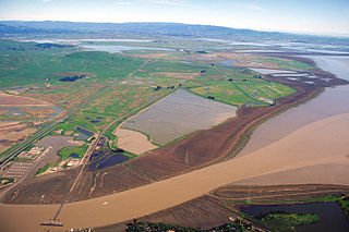
The Napa Sonoma Marsh is a wetland at the northern edge of San Pablo Bay, which is a northern arm of the San Francisco Bay in California, United States. This marsh has an area of 48,000 acres (194 km2), of which 13,000 acres (53 km2) are abandoned salt evaporation ponds.[ citation needed ] The United States Government has designated 13,000 acres (53 km2) in the Napa Sonoma Marsh as the San Pablo Bay National Wildlife Refuge.[ citation needed ]

Wetland A land area that is permanently or seasonally saturated with water

A wetland is a distinct ecosystem that is inundated by water, either permanently or seasonally, where oxygen-free processes prevail. The primary factor that distinguishes wetlands from other land forms or water bodies is the characteristic vegetation of aquatic plants, adapted to the unique hydric soil. Wetlands play a number of functions, including water purification, water storage, processing of carbon and other nutrients, stabilization of shorelines, and support of plants and animals. Wetlands are also considered the most biologically diverse of all ecosystems, serving as home to a wide range of plant and animal life. Whether any individual wetland performs these functions, and the degree to which it performs them, depends on characteristics of that wetland and the lands and waters near it. Methods for rapidly assessing these functions, wetland ecological health, and general wetland condition have been developed in many regions and have contributed to wetland conservation partly by raising public awareness of the functions and the ecosystem services some wetlands provide.

San Pablo Bay bay in San Francisco Bay area

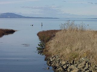
San Pablo Bay is a tidal estuary that forms the northern extension of San Francisco Bay in the East Bay and North Bay regions of the San Francisco Bay Area in northern California.

San Francisco Bay bay on the California coast of the United States

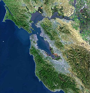
San Francisco Bay is a shallow estuary in the US state of California. It is surrounded by a contiguous region known as the San Francisco Bay Area, and is dominated by the large cities of San Jose, San Francisco and Oakland.

Contents

The marsh is fed by Sonoma Creek (which drains the Sonoma Valley), Tolay Creek (originating in the Tolay Lake basin), and the Napa River (which drains the Napa Valley). [1] Although the marsh extends north as far as State Route 12, [2] as a practical matter, most of the marsh is only accessible by boat.

Sonoma Creek stream in California

Sonoma Creek is a 33.4-mile-long (53.8 km) stream in northern California. It is one of two principal drainages of southern Sonoma County, California, with headwaters rising in the rugged hills of Sugarloaf Ridge State Park and discharging to San Pablo Bay, the northern arm of San Francisco Bay. The watershed drained by Sonoma Creek is roughly equivalent to the wine region of Sonoma Valley, an area of about 170 square miles (440 km2). The State of California has designated the Sonoma Creek watershed as a “Critical Coastal Water Resource”. To the east of this generally rectangular watershed is the Napa River watershed, and to the west are the Petaluma River and Tolay Creek watersheds.

Sonoma Valley region in Sonoma County, California

Sonoma Valley is a valley located in southeastern Sonoma County, California, in the San Francisco Bay Area. Known as the birthplace of the California wine industry, the valley is home to some of the earliest vineyards and wineries in the state, some of which survived the phylloxera epidemic of the 1870s and the impact of prohibition in the early 20th century. Today, the valley's wines are protected by the US Federal Government's Sonoma Valley and Carneros AVAs.

Tolay Creek is a 12.5-mile-long (20.1 km) southward-flowing stream in southern Sonoma County, California, United States, which flows through Tolay Lake and ends in north San Pablo Bay.

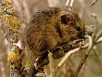
The marsh is a productive estuarine ecosystem providing habitat for a wide diversity of flora and fauna, including numerous rare and endangered species such as the California clapper rail and California freshwater shrimp. [3] Because of its rich avafaunal content, the Napa Sonoma Marsh is one of only seven marshes selected for intensive study by the Point Reyes Bird Observatory (based on a total of 50 discrete marshes appurtenant to the San Francisco Bay). [4]

Ecosystem A community of living organisms together with the nonliving components of their environment

An ecosystem is a community of living organisms in conjunction with the nonliving components of their environment, interacting as a system. These biotic and abiotic components are linked together through nutrient cycles and energy flows. Energy enters the system through photosynthesis and is incorporated into plant tissue. By feeding on plants and on one-another, animals play an important role in the movement of matter and energy through the system. They also influence the quantity of plant and microbial biomass present. By breaking down dead organic matter, decomposers release carbon back to the atmosphere and facilitate nutrient cycling by converting nutrients stored in dead biomass back to a form that can be readily used by plants and other microbes.

Habitat ecological or environmental area inhabited by a particular species; natural environment in which an organism lives, or the physical environment that surrounds a species population

In ecology, a habitat is the type of natural environment in which a particular species of organism lives. It is characterized by both physical and biological features. A species' habitat is those places where it can find food, shelter, protection and mates for reproduction.

Biodiversity Variety and variability of life forms

Biodiversity refers to the variety and variability of life on Earth. Biodiversity is typically a measure of variation at the genetic, species, and ecosystem level. Terrestrial biodiversity is usually greater near the equator, which is the result of the warm climate and high primary productivity. Biodiversity is not distributed evenly on Earth, and is richest in the tropics. These tropical forest ecosystems cover less than 10 percent of earth's surface, and contain about 90 percent of the world's species. Marine biodiversity is usually highest along coasts in the Western Pacific, where sea surface temperature is highest, and in the mid-latitudinal band in all oceans. There are latitudinal gradients in species diversity. Biodiversity generally tends to cluster in hotspots, and has been increasing through time, but will be likely to slow in the future.

Around 1860, the Napa Sonoma Marsh was one of the most productive wetlands of the Pacific Coast, providing habitat for millions of birds. [5] By the mid-1980s, the San Francisco Bay perimeter had lost over 91 percent of its wetlands. The Napa Sonoma Marsh represents one of the few sizeable expanses where restoration is feasible. [6]

An extensive research literature base exists for the Napa Sonoma Marsh. [7]

See also

Hydrography of the San Francisco Bay Area

The Hydrography of the San Francisco Bay Area is a complex network of watersheds, marshes, rivers, creeks, reservoirs, and bays predominantly draining into the San Francisco Bay and Pacific Ocean.

Salt marsh harvest mouse species of mammal

The salt marsh harvest mouse, also known as the red-bellied harvest mouse and sometimes called the saltmarsh harvest mouse, is an endangered rodent endemic to the San Francisco Bay Area salt marshes in California. There are two distinct subspecies, both endangered and listed together on federal and state endangered species lists. The northern subspecies is lighter in color and inhabits the northern marshes of the bay, and the southern subspecies lives in the East and South Bay marshes. They are both quite similar in appearance to their congener species, the [Western harvest mouse, R. megalotis], to which they are not closely related. Genetic studies of the northern subspecies have revealed that the salt marsh harvest mouse is most closely related to the plains harvest mouse, R. montanus,, which occurs now in the Midwest]. Its endangered designation is due to its limited range, historic decline in population and continuing threat of habitat loss due to development encroachment at the perimeter of San Francisco Bay.

Sears Point landform in Sonoma County, California

Sears Point is a prominent landform that juts into the San Pablo Bay in Sonoma County, California, United States. This hill is the southernmost peak of the Sonoma Mountains and forms the southwestern ridge above Tolay Lake. Starting with European settlement of this area in the mid-19th century considerable modification of the Napa Sonoma Marsh began to occur, such that in contemporary times, there is considerable upland between Sears Point and San Pablo Bay. Numerous local conservation organizations are presently working to restore hundreds of acres of these historic tidal wetlands as part of the Sears Point Wetlands and Watershed Restoration Project. The region can be accessed via State Route 37 or State Route 121.

Related Research Articles

Wine Country (California) area of Northern California known as a wine-growing region

Wine Country is the region of California, in the northern Bay Area, known worldwide as a premium wine-growing region. The region is famed for its wineries, its cuisine,, Michelin star restaurants, boutique hotels, luxury resorts, historic architecture, and culture. Viticulture and wine-making have been practiced in the region since the Spanish missionaries from Mission San Francisco Solano established the first vineyards in 1812.

Napa River river in the United States of America

The Napa River, approximately 55 miles (89 km) long, is a river in the U.S. state of California. It drains a famous wine-growing region, called the Napa Valley, in the mountains northeast of San Francisco. Milliken Creek and Mt. Veeder watersheds are a few of its many tributaries. The mouth is at Vallejo where the inter-tidal zone of fresh and salt waters flow into the Carquinez Straits on San Pablo Bay.

North Bay (San Francisco Bay Area) subregion of the San Francisco Bay Area in California, United States

The North Bay is a subregion of the San Francisco Bay Area, in California, United States. The largest city is Santa Rosa, which is the fifth-largest city in the Bay Area. It is the location of the Napa and Sonoma wine regions, and is the least populous and least urbanized part of the Bay Area. It consists of Marin, Napa, Solano and Sonoma counties.

Don Edwards San Francisco Bay National Wildlife Refuge United States National Wildlife Refuge

Don Edwards San Francisco Bay National Wildlife Refuge (DESFBNWR) is a United States National Wildlife Refuge located in the southern part of San Francisco Bay, California. The Refuge headquarters and visitor center is located in the Baylands district of Fremont, next to Coyote Hills Regional Park, in Alameda County. The visitor center is on Marshlands Rd, off Thornton Ave.

The California Coastal Conservancy is a state agency in California established in 1976 to enhance coastal resources and access.

Bair Island

Bair Island is a marsh area in Redwood City, California covering 3,000 acres (1,200 ha), and includes three islands: Inner, Middle and Outer islands. Bair Island is part of the larger Don Edwards San Francisco Bay National Wildlife Refuge. It is surrounded by the Steinberger slough to the northwest and Redwood Creek to the southeast.

Petaluma River river in California

The Petaluma River is a river in the California counties of Sonoma and Marin that becomes a tidal slough for the majority of its length. The headwaters are in the area southwest of Cotati. The flow is generally southward through Petaluma's old town, where the waterway becomes navigable, and then flows another 10 mi (16 km) through tidal marshes before emptying into the northwest corner of San Pablo Bay.

Suisun Marsh

Located in northern California the Suisun Marsh is the largest brackish water marsh on west coast of the United States of America. The marsh land is part of the San Francisco Bay tidal estuary, and subject to tidal ebb and flood. The marsh is home to many species of birds and other wildlife, and is formed by the confluence of the Sacramento and San Joaquin rivers between Martinez and Suisun City, California and several other smaller, local watersheds. Adjacent to Suisun Bay, the marsh is immediately west of the legally defined Sacramento-San Joaquin Delta as well as part of the San Francisco Bay estuary.

Tolay Lake lake in Sonoma County, California

Tolay Lake is a shallow freshwater lake in southern Sonoma County, California, United States. The lake, nestled within the southern vestiges of the Sonoma Mountains, is the site of significant Native American prehistoric seasonal settlement. In 2005, Sonoma County acquired the entirety of the lake and virtually its whole drainage basin from the Cardoza family for the sum of $18 million; the County's intention is to utilize the property as Tolay Lake Regional Park for ecological and archaeological preservation, as well as public use and enjoyment. Tolay Lake and its immediate drainage area is home to several nesting pairs of golden eagles, Aquila chrysaetos, and a number of rare, threatened or endangered species including the California red-legged frog, Rana draytonii; Western pond turtle, Actinemys marmorata; and Western burrowing owl, Athene cunicularia.

Hamilton Wetland Restoration Project

The Hamilton Wetland Restoration Project, now known as the Hamilton/Bel Marin Keys Wetlands Restoration is a wetlands habitat restoration project at the former Hamilton Air Force Base—Hamilton Army Airfield (1930−1988) site and adjacent Bel Marin Keys shoreline, in Marin County, California.

Point San Pablo Harbor human settlement in Richmond, California, United States of America

Point San Pablo Harbor is a marina and small community at the far end of Point San Pablo in San Pablo Bay, within Richmond, in Contra Costa County, California. It is located at 1900 Stenmark Drive, Richmond CA 94801.

San Pablo Bay National Wildlife Refuge

San Pablo Bay National Wildlife Refuge is a 13,190-acre (53.4 km2) National Wildlife Refuge in California established in 1970. It extends along the northern shore of San Pablo Bay, from the mouth of the Petaluma River, to Tolay Creek, Sonoma Creek, and ending at Mare Island.

Dotson Family Marsh

The Dotson Family Marsh, formerly Breuner Marsh, is a 238-acre regional park on San Pablo Bay in the East San Francisco Bay Area city of Richmond, California, In 2009 the East Bay Regional Parks District acquired the Breuner Marsh site, adding it to Point Pinole Regional Shoreline. A habitat restoration plan for 60 acres of wetlands and 90 acres of California coastal prairie was subsequently approved.

Chelsea Wetlands is a riparian marsh on lower Pinole Creek and a tidal wetland at its mouth on San Pablo Bay, in Contra Costa County, northern California. It is located within the city of Hercules, in the East Bay region of the San Francisco Bay Area.

Skaggs Island Naval Communication Station is a former United States Navy installation located near California State Route 37 between Novato and Vallejo, California. It was a secretive, secure, and self-contained naval base, engaged in a number of communications and intelligence gathering functions for the Navy and other federal intelligence organizations. The 3,310-acre (13.4 km2) site was purchased by the Navy in 1941, and closed in 1993. The antennas continued to be used for some time after that, but by 2013 they were removed along with all of the remaining buildings.

References

Coordinates: 38°10′07″N122°20′22″W / 38.16871°N 122.33946°W / 38.16871; -122.33946