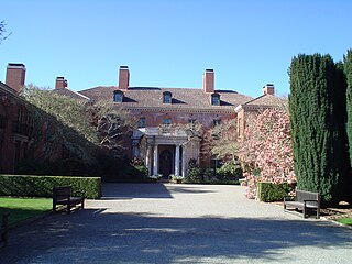
Filoli is a country house set in 16 acres (6.5 ha) of formal gardens surrounded by a 654-acre (265 ha) estate, located in Woodside, California, about 25 miles (40 km) south of San Francisco, at the southern end of Crystal Springs Reservoir, on the eastern slope of the Santa Cruz Mountains. Now owned by the National Trust for Historic Preservation, Filoli is open to the public. The site is both a California Historical Landmark and listed on the National Register of Historic Places.

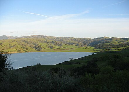
Arroyo Hondo is a northwestward-flowing 13.0-mile-long (20.9 km) river in Santa Clara County, California, United States, that lies east of Milpitas. The area is privately owned by the San Francisco Water Department and is closed to public access because of its usage as drinking water. Bounded to the east by Oak Ridge and to the west by Poverty Ridge, Arroyo Hondo empties into the Calaveras Reservoir where it joins Calaveras Creek. It is formed by the confluence of Smith Creek and Isabel Creek which drain the west and east slopes of Mount Hamilton, respectively.
Coyote Creek is a river that flows through the Santa Clara Valley in California, United States.

Lagunitas Creek is a 24 miles (39 km)-long northward-flowing stream in Marin County, California. It is critically important to the largest spawning runs of endangered coho salmon in the Central California Coast Coho salmon Evolutionary Significant Unit. The stream's headwaters begin on the northern slopes of Mt. Tamalpais in the Coast Range and terminate in southeast Tomales Bay, 1.5 miles (2.4 km) northwest of Point Reyes Station, California. Lagunitas Creek feeds several reservoirs on Mt. Tamalpais that supply a major portion of the county's drinking water.

Alameda Creek is a large perennial stream in the San Francisco Bay Area. The creek runs for 45 miles (72 km) from a lake northeast of Packard Ridge to the eastern shore of San Francisco Bay by way of Niles Canyon and a flood control channel.
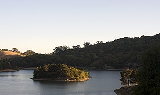
Crystal Springs Reservoir is a pair of artificial lakes located in the northern Santa Cruz Mountains of San Mateo County, California situated in the rift valley created by the San Andreas Fault just to the west of the cities of San Mateo and Hillsborough, and I-280. The lakes are part of the San Mateo Creek watershed.

San Andreas Lake is a reservoir adjacent to the San Francisco Peninsula cities of Millbrae and San Bruno in San Mateo County, California. It is situated directly on the San Andreas Fault, which is named after the valley it is in.
Lake Chabot is a man-made lake covering 317 acres (1.3 km2) in Alameda County, California, United States. Part of the lake lies within Oakland city limits, but most of it lies in unincorporated Castro Valley, just east of San Leandro. It was formed by the damming of San Leandro Creek. The lake was completed in 1875 to serve as a primary source of water for the East Bay.

San Francisquito Creek is a creek that flows into southwest San Francisco Bay in California, United States. Historically it was called the Arroyo de San Francisco by Juan Bautista de Anza in 1776. San Francisquito Creek courses through the towns of Portola Valley and Woodside, as well as the cities of Menlo Park, Palo Alto, and East Palo Alto. The creek and its Los Trancos Creek tributary define the boundary between San Mateo and Santa Clara counties.

San Leandro Creek is a 21.7-mile-long (34.9 km) year-round natural stream in the Oakland Hills, in Alameda County and Contra Costa County of the East Bay in northern California.

San Mateo Creek is a perennial stream whose watershed includes Crystal Springs Reservoir, for which it is the only natural outlet after passing Crystal Springs Dam.
Tolay Creek is a 12.5-mile-long (20.1 km) southward-flowing stream in southern Sonoma County, California, United States, which flows through Tolay Lake and ends in north San Pablo Bay.
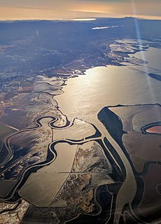
The Hydrography of the San Francisco Bay Area is a complex network of watersheds, marshes, rivers, creeks, reservoirs, and bays predominantly draining into the San Francisco Bay and Pacific Ocean.
Kent Lake is a reservoir in western Marin County, California formed by the construction of Peters Dam across Lagunitas Creek. Built in 1954, the lake is the most recent lake of the Marin Municipal Water District, as well as the largest. It lies to the west of Alpine Lake; among the five major lakes in the area it is the only one to the west of Fairfax-Bolinas Road.
Lake Lagunita is an artificial dry lake in Stanford University, California, located on the western side of the Stanford campus near the Lagunita residences.

Laguna Creek is a perennial stream that flows northwesterly for 2.6-mile (4.2 km) along the San Andreas Fault from Woodside in San Mateo County, California and, after crossing the Phleger Estate and Filoli, enters Upper Crystal Springs Reservoir, where it is a historic tributary to San Mateo Creek. San Mateo Creek then carries its waters over Crystal Springs Dam northeast to San Francisco Bay.
San Felipe Creek is a 14 miles (23 km) stream that originates in the western Diablo Range in Santa Clara County, California. It flows south by southeast through two historic ranchos, Rancho Los Huecos and Rancho Cañada de San Felipe y Las Animas before it joins Las Animas Creek just above Anderson Reservoir. One of the nine major tributaries of Coyote Creek, the creek’s waters pass through the Santa Clara Valley and San Jose on the way to San Francisco Bay.

The Laguna Creek watershed consists of 25.1 square miles (100 km2) of land within northern California's Alameda County. The watershed drains the foothills of the Diablo Range south of Niles Canyon. To the southeast, the area of Mission Peak Regional Preserve around Mission Peak is included. Agua Caliente, Canada del Aliso, Mission, Morrison, Sabercat, Vargas, and Washington creeks drain the area of the watershed. They drain into Laguna Creek and eventually Mud Slough.