
Contra Costa County is a county located in the U.S. state of California, in the East Bay of the San Francisco Bay Area. As of the 2020 United States Census, the population was 1,165,927. The county seat is Martinez. It occupies the northern portion of the East Bay region of the San Francisco Bay Area and is primarily suburban. The county's name refers to its position on the other side of the bay from San Francisco. Contra Costa County is included in the San Francisco–Oakland–Berkeley, CA Metropolitan Statistical Area.

The East Bay Regional Park District (EBRPD) is a special district operating in Alameda County and Contra Costa County, California, within the East Bay area of the San Francisco Bay Area. It maintains and operates a system of regional parks which is the largest urban regional park district in the United States. The administrative office is located in Oakland.

Pettigrew State Park is a North Carolina State Park in Tyrrell and Washington Counties, North Carolina in the United States. It covers 5,951 acres (24.08 km2) around the shore lines of Lake Phelps and the Scuppernong River. The park's developed facilities are south of U.S. Route 64 near Roper and Creswell, North Carolina. Pettigrew State Park is open for year-round recreation, including hiking, camping, fishing, boating and picnicking.
Brannan Island State Recreation Area is a state park unit of California, United States, preserving a maze of waterways in the Sacramento–San Joaquin River Delta. The recreation area is located in Sacramento County between Rio Vista and Isleton. This park northeast of San Francisco Bay has countless islands and marshes with many wildlife habitats and many opportunities for recreation, including boating, windsurfing and swimming. The 329-acre (133 ha) park was established in 1952.

The Sacramento–San Joaquin River Delta, or California Delta, is an expansive inland river delta and estuary in Northern California. The delta is formed at the western edge of the Central Valley by the confluence of the Sacramento and San Joaquin rivers and lies just east of where the rivers enter Suisun Bay, which flows into San Francisco Bay, then the Pacific Ocean via San Pablo Bay. The Delta is recognized for protection by the California Bays and Estuaries Policy. Sacramento–San Joaquin Delta was designated a National Heritage Area on March 12, 2019. The city of Stockton is located on the San Joaquin River at the eastern edge of the delta. The total area of the Delta, including both land and water, is about 1,100 square miles (2,800 km2). Its population is around 500,000.

Lake Murray is a reservoir in San Diego, California, operated by the City of San Diego's Public Utilities Department. When full, the reservoir covers 171.1 acres (69.2 ha), has a maximum water depth of 95 feet (29 m), and a shoreline of 3.2 miles (5.1 km). The asphalt-paved service road lining roughly two-thirds of the lake's perimeter is a popular recreation site for the Navajo community as well as residents of the northernmost neighborhoods in La Mesa. It lies south of Cowles Mountain and a small golf course. It also functions as an important aeronautical reporting point for aircraft inbound to land at Montgomery-Gibbs Executive Airport.

Franks Tract State Recreation Area (SRA) is a state park unit of California, United States, featuring a flooded area in the Sacramento–San Joaquin River Delta. It is accessible only by water. Franks Tract, and a smaller adjoining submerged property called "Little Franks Tract", are situated between the False River and Bethel Island. The recreation area is used primarily for fishing and waterfowl hunting, because of its exposure to frequent strong winds and fluctuating water levels. In times of high water, the entire site can be submerged except for portions of the old levees. The 3,523-acre (1,426 ha) park was established in 1959. It is managed from nearby Brannan Island State Recreation Area, 6 miles (9.7 km) to the northwest.

Lake Lafayette is a prairie lake located in the coastal lowland in eastern Tallahassee, Leon County, Florida with US 27 / State Road 20 running close on its south side.

Folsom Lake is a reservoir on the American River in the Sierra Nevada foothills of California, United States. Folsom Lake with its surrounding Folsom Lake State Recreation Area is one of the most visited parks in the California park system.
Sheldon Lake is a reservoir on Carpenters Bayou in the San Jacinto River basin, 16 miles (26 km) northeast of downtown Houston, Texas. The reservoir was created in 1943 when the federal government built a dam to provide fresh water for shipbuilding and shipping industries on the Houston Ship Channel during World War II. After the war, the management of the reservoir was assumed by the City of Houston. In 1952, after the construction of the dam that creates Lake Houston, the city sold the reservoir to the Texas Parks and Wildlife Department for use as a waterfowl sanctuary and public fishing site. In 1984, the land around the reservoir was designated the Sheldon State Wildlife Management Area.

Lake Perris is an artificial lake completed in 1973. It is the southern terminus of the California State Water Project, situated in a mountain-rimmed valley between Moreno Valley and Perris, in what is now the Lake Perris State Recreation Area. The park offers a variety of recreational activities. Because of this and the lake's proximity to major population centers, it is very crowded during the summer months.

Lake Natoma is a small lake in the Western United States, along the lower American River, between Folsom and Nimbus Dams in Sacramento County, California. The lake is located within the Folsom Lake State Recreation Area which maintains the facilities and bike trails surrounding the lake. Lake Natoma is located 15 miles (24 km) east of Sacramento, and has 500 surface acres of water. The total length of lake Natoma is 4 miles (6.4 km).

The Contra Costa Canal is a 47 mi (76 km) aqueduct in the US state of California. Its construction began in 1937, with delayed completion until 1948 due to World War II shortages in labor and materials. A portion of the canal's right of way has been developed as the Contra Costa Canal Regional Trail, a biking and walking trail, and is managed by the East Bay Regional Park District.
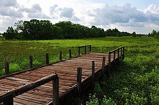
Antioch/Oakley Regional Shoreline is a regional park that is part of the East Bay Regional Parks system. It is located on the south shore of the San Joaquin River in Contra Costa County, California, between the cities of Antioch and Oakley. It is owned by the State of California and operated on a no-cost lease by the East Bay Regional Parks District. The park was begun in 1979, when the adjacent John Nejedly Bridge was constructed across the river. The park was originally named Antioch Regional Shoreline, and was given its present name when Oakley incorporated as a city in 1999.

The Los Vaqueros Reservoir and watershed is located in the northern Diablo Range, within northeastern Contra Costa County, northern California. It was completed by the Contra Costa Water District (CCWD) in 1998 to improve the quality of drinking water for its 550,000 customers in Central and Eastern Contra Costa County. The reservoir is accessible via Vasco Road, a road which connects Brentwood and Livermore.
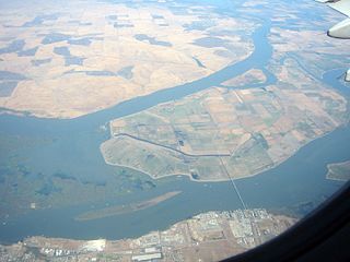
Sherman Island is an island in the Sacramento-San Joaquin River Delta at the confluence of the two rivers in Sacramento County, California, 1.2 miles (1.9 km) northeast of Antioch. The 5,500 ha island, mostly managed by Reclamation District 341, is the meeting point of Sacramento, Solano, and Contra Costa Counties, and is bordered on the north and northwest by the Sacramento River, on the northeast by Three Mile Slough, and on the east, and south west by the San Joaquin River. Sherman Island is a widely known kite and windsurfing area.
Richland-Chambers Reservoir is the third largest inland reservoir by surface area and the 8th largest reservoir by water volume in Texas formed by the impoundment of Richland Creek and Chambers Creek east-southeast of the town of Corsicana and south of Kerens, in Navarro County and Freestone County, Texas, USA. It has 330 miles (530 km) of shoreline and is Y-shaped with the dam on the eastern end of the lake.
Marsh Creek is a stream in east Contra Costa County, California in Northern California which rises on the eastern side of Mount Diablo and flows 30 miles (48 km) to the Sacramento–San Joaquin River Delta at Oakley, California, near Big Break Regional Shoreline. The creek flows through Marsh Creek State Park (California), where water is impounded to form Marsh Creek Reservoir, then through the city of Brentwood, California.
Klondike Park is a county park in St. Charles County, Missouri. The park offers access to hiking and cycling trails including the Katy Trail. Camping and fishing facilities are also available. Klondike park also has a very diverse set of wildlife and habitats.

Bradford Island is a 2,172-acre (879 ha) island of the Sacramento–San Joaquin River Delta, in Contra Costa County, California, United States. Bradford Island is inaccessible by roads, and is served by a ferry across the False River from nearby Jersey Island. Approximately 48 people lived on the island as of 2020. Other uses of land include wheat farming, cattle grazing, and natural gas extraction.

