
The East Bay Regional Park District (EBRPD) is a special district operating in Alameda County and Contra Costa County, California, within the East Bay area of the San Francisco Bay Area. It maintains and operates a system of regional parks which is the largest urban regional park district in the United States. The administrative office is located in Oakland.

Donner Lake, formerly known as Truckee Lake, is a freshwater lake in Northeast California on the eastern slope of the Sierra Nevada and about 20 miles (32 km) northwest of the much larger Lake Tahoe. A moraine serves as a natural dam for the lake. The lake is located in the town of Truckee, between Interstate 80 to the north and Schallenberger Ridge to the south. The tracks of the Union Pacific Railroad run along Schallenberger Ridge and closely follow the route of the original transcontinental railroad. The historic route of the Lincoln Highway, the first automobile road across America and US 40 follows the northern shoreline, then climbs to Donner Pass from where the entire lake may be viewed.

The Iron Horse Regional Trail is a rail trail for pedestrians, horse riders and bicycles in the East Bay Area in California.

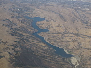
Lake Berryessa is the largest lake in Napa County, California, United States. This reservoir in the Vaca Mountains was formed following the construction of the Monticello Dam on Putah Creek in the 1950s. Since the early 1960s, this reservoir has provided water and hydroelectricity to the North Bay region of the San Francisco Bay Area.

Stevens Creek Reservoir is an artificial lake located in the foothills of the Santa Cruz Mountains near Cupertino, California. A 1,063-acre (430 ha) county park surrounds the reservoir and provides limited fishing, picnicking, hiking, and horseback riding activities. Although swimming is not allowed, non-power boating is allowed for certain parts of the year. No powered boats or jet skis are allowed. All vessels must be inspected for invasive Quagga mussels prior to launch.

Huntington State Beach is a protected beach in Southern California, located in the City of Huntington Beach in Orange County. It extends 2 miles (3.2 km) from Newport Beach north to Beach Boulevard, where the Huntington City Beach begins. The 121-acre (49 ha) park was established in 1942.

Temescal Regional Recreation Area (TRRA), formerly Lake Temescal Regional Park, is a regional park in the Berkeley Hills, in northeastern Oakland, California. The TRRA encompasses 48 acres (19 ha), abutting SR 24, SR13, and the interchange connecting the two highways, southwest of the Caldecott Tunnel.The park is part of the East Bay Regional Park District (EBRPD).

Mission Bay is an artificial, saltwater bay located south of the Pacific Beach community of San Diego, California, created from approximately 2,000 acres (810 ha) of historical wetland, marsh, and saltwater bay habitat. The bay is part of the recreational Mission Bay Park, the largest man-made aquatic park in the United States, consisting of 4,235 acres (17.14 km2), approximately 46% land and 54% water. The combined area makes Mission Bay Park the ninth largest municipally-owned park in the United States.

Castaic Lake is a reservoir formed by Castaic Dam on Castaic Creek, in the Sierra Pelona Mountains of northwestern Los Angeles County, California, United States, near the town of Castaic.

Folsom Lake is a reservoir on the American River in the Sierra Nevada foothills of California, United States. Folsom Lake with its surrounding Folsom Lake State Recreation Area is one of the most visited parks in the California park system.

Lake Perris is an artificial lake completed in 1973. It is the southern terminus of the California State Water Project, situated in a mountain-rimmed valley between Moreno Valley and Perris, in what is now the Lake Perris State Recreation Area. The park offers a variety of recreational activities. Because of this and the lake's proximity to major population centers, it is very crowded during the summer months.
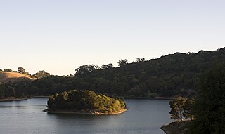
Lake Chabot is a man-made lake covering 317 acres (1.3 km2) in Alameda County, California, United States. Part of the lake lies within Oakland city limits, but most of it lies in unincorporated Castro Valley, just east of San Leandro. It was formed by the damming of San Leandro Creek. The lake was completed in 1875 to serve as a primary source of water for the East Bay.

Silverwood Lake is a large reservoir in San Bernardino County, California, United States, located on the West Fork Mojave River, a tributary of the Mojave River in the San Bernardino Mountains. It was created in 1971 as part of the State Water Project by the construction of the Cedar Springs Dam as a forebay on the 444 mi (715 km) long California Aqueduct, and has a capacity of 73,000 acre⋅ft (90,000,000 m3).

The San Pablo Reservoir is an open cut terminal water storage reservoir owned and operated by the East Bay Municipal Utility District (EBMUD). It is located in the valley of San Pablo Creek, north of Orinda, California, United States, and south of El Sobrante and Richmond, east of the Berkeley Hills between San Pablo Ridge and Sobrante Ridge.

Cull Canyon Regional Recreation Area (CCRRA) is a regional park located in Castro Valley, Alameda County, California. It is part of the East Bay Regional Park District (EBRPD) system.
Del Valle Regional Park is a part of the East Bay Regional Park District (EBRPD) in an unincorporated region of Alameda County, California, 10 miles (16 km) south of the city of Livermore. The park covers 4,316 acres.
Puddingstone Reservoir is a 250-acre (1 km²) artificial lake northeast of the interchange between the Orange Freeway and the San Bernardino Freeway in Los Angeles County, California, United States. Activities include fishing, swimming, sailing, windsurfing, and camping. It is fed by Live Oak Wash and drains into Walnut Creek.

Lake Piru is a reservoir located in Los Padres National Forest and Topatopa Mountains of Ventura County, California, created by the construction in 1955 of the Santa Felicia Dam on Piru Creek, which is a tributary of the Santa Clara River.

Coyote Lake is an artificial lake in Santa Clara County, California, United States, between Morgan Hill and Gilroy.

Vasona Reservoir is an artificial lake located in Los Gatos, California, United States. A 152-acre (62 ha) county park surrounds the reservoir and provides limited fishing, picnicking, and informal play activities. Although swimming is not allowed, human-powered boating is permitted in the reservoir.


