
Contra Costa County is a county located in the U.S. state of California, in the East Bay of the San Francisco Bay Area. As of the 2020 United States Census, the population was 1,165,927. The county seat is Martinez. It occupies the northern portion of the East Bay region of the San Francisco Bay Area and is primarily suburban. The county's name refers to its position on the other side of the bay from San Francisco. Contra Costa County is included in the San Francisco–Oakland–Berkeley, CA Metropolitan Statistical Area.

Livermore is a city in Alameda County, California. With a 2020 population of 87,955, Livermore is the most populous city in the Tri-Valley, giving its name to the Livermore Valley. It is located on the eastern edge of California's San Francisco Bay Area, making it the easternmost city in the area.

The East Bay Regional Park District (EBRPD) is a special district operating in Alameda County and Contra Costa County, California, within the East Bay area of the San Francisco Bay Area. It maintains and operates a system of regional parks which is the largest urban regional park district in the United States. The administrative office is located in Oakland.
The Sunol Regional Wilderness is a regional park in Alameda County, the eastern San Francisco Bay Area, Northern California. It is located near the town of Sunol, south of Pleasanton and east of Fremont.

The Tri-Valley area is grouping of three valleys in the East Bay region of California's Bay Area. The three valleys are Amador Valley, Livermore Valley, and San Ramon Valley. The Tri-Valley encompasses the cities of Dublin, Livermore, Pleasanton and San Ramon, the town of Danville, and the CDPs of Alamo, Blackhawk, Camino Tassajara, Diablo, and Norris Canyon. The area is known for its Mediterranean climate, wineries, and nature. It is primarily suburban in character. The total population of the Tri-Valley was 400,213 at the 2020 U.S. Census. It offers more affordable living accommodations than the cities of San Francisco and San Jose.
Mission Peak is a mountain peak located east of Fremont, California. It is the northern summit on a ridge that includes Mount Allison and Monument Peak. Mission Peak has symbolic importance, and is depicted on the logo of the City of Fremont. It is located in Mission Peak Regional Preserve, a regional park operated by the East Bay Regional Park District.
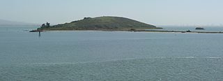
Brooks Island Regional Preserve includes both the 75-acre (30 ha) of Brooks Island above the low-tide line and 300 acres (120 ha) of the surrounding bay. The only public access to the island is via an East Bay Regional Park District naturalist tour.
Briones Regional Park is a 6,117-acre (24.75 km2) regional park in the East Bay Regional Park District (EBRPD) system, located in the Briones Hills of central Contra Costa County of the San Francisco Bay Area in California.

Cull Canyon Regional Recreation Area (CCRRA) is a regional park located in Castro Valley, Alameda County, California. It is part of the East Bay Regional Park District (EBRPD) system.
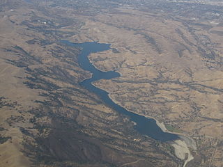
Del Valle Regional Park is a part of the East Bay Regional Park District (EBRPD) in an unincorporated region of Alameda County, California, 10 miles (16 km) south of the city of Livermore. The park covers 4,316 acres.
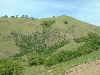
Morgan Territory Regional Preserve is a regional park in Contra Costa County, California. Located east of Clayton and north of Livermore, California, bordering on Mt. Diablo State Park, it is part of the East Bay Regional Park District (EBRPD). The preserve was founded in 1975 with fewer than 1,000 acres (400 ha), but EBRPD has gradually acquired more property, and, since 2015, the preserve encompasses 5,230 acres (2,120 ha). The main access roads run from Livermore and Clayton.

Ohlone Wilderness is a 9,737 acres (39.40 km2) regional park in the United States that is part of the East Bay Regional Parks (EBRPD) system. It is located in southern Alameda County, near the cities of Fremont, California and Sunol, California. It is located between Mission Peak and Sunol Regional Wilderness.
Round Valley Regional Preserve is a regional park just outside Antioch, CA and Brentwood, CA that is part of the East Bay Regional Parks (EBRPD) system. It is on Marsh Creek Road, approximately 5.2 miles (8.4 km) west of the intersection with Vasco Road. The park was begun in 1988, when Jim Murphy sold 700 acres (280 ha) of land to EBRPD. The land originally belonged to Mr. Davis' grandfather Thomas Murphy, an Irish immigrant, who had purchased the land in 1878 for a farming and ranching operation. The preserve has since expanded to encompass 1,911 acres (773 ha).
Sobrante Ridge Regional Preserve (SRRP) is a regional park in Richmond, Contra Costa County, California and is part of the East Bay Regional Parks (EBRPD) system. The park preserves one of the few habitats of the Alameda manzanita, which is deemed extremely rare, according to EBRPD.
Citizens for East Shore Parks (CESP) is a United States environmental organization that focuses on the acquisition and preservation of parkland in the San Francisco Bay Area. CESP works to protect open space along the East Bay shoreline for natural habitat and recreational purposes through a combination of advocacy, education, and outreach. Since its founding in 1985, CESP has worked to secure approximately 1,800 acres (730 ha) of public land, primarily through the creation of the 8.5-mile (13.7 km) long Eastshore State Park in 2002.
Vasco Road is a roadway over the Diablo Range that connects Livermore and Brentwood, California. Although it is not part of the California State Highway system, it is the principal north–south commuter route serving eastern Alameda and Contra Costa counties. The two counties are each responsible for maintaining the portion of the road within their boundaries.
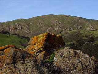
Vasco Caves Regional Preserve is a natural and cultural protected area located on the eastern slope of Mount Diablo, on Vasco Road within eastern Contra Costa County, California. It was created to preserve wildlife habitats, California chaparral and woodlands, native plant communities, and Native American rock art.
Vargas Plateau Regional Park sits on a plateau in the Fremont Hills of Alameda County, California that overlooks the San Francisco Bay, Niles Canyon, and the cities of Fremont, Union City, and Newark. The elevation of the park is about 1,000 feet (300 m), making it an important link with nearby ridge-top parks such as Garin Regional Park, Pleasanton Ridge Regional Park, Mission Peak Regional Preserve, and Sunol Regional Wilderness.

Five Canyons Open Space (FCOS) is located in Castro Valley, in Alameda County, California. Five Canyons is a multi-agency collaboration between East Bay Regional Parks District (EBRPD), Alameda County Public Works, Hayward Area Recreation and Parks District (HARD), and several homeowners associations. EBRPD is the lead agency for this open space. FCOS opened in 1998, consists of 300 acres (1.2 km2) and 5 miles (8.0 km) of trails and has almost no amenities. The main visitors are hikers, bicyclists, equestrians and dog walkers. Restrooms and drinking water are available at HARD's nearby Five Canyons Park.
Brushy Peak, also known as Brushy Knob or Las Cuevas, is a summit in Alameda County, California that overlooks the Livermore Valley. North of the valley, it is part of the Diablo Range. It rises to an elevation of 1,686 feet (514 m) and is the location of Brushy Peak Regional Preserve; there are guided tours to the peak itself.


