
Charles Lee Tilden Regional Park, also known as Tilden Park or Tilden, [], is a 2,079-acre (841 ha) regional park in the East Bay, part of the San Francisco Bay Area in California. It is between the Berkeley Hills and San Pablo Ridge. Its main entrance is near Kensington, Berkeley, and Richmond. The park is contiguous with Wildcat Canyon Regional Park.

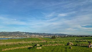
Point Pinole Regional Shoreline is a regional park on the shores of the San Pablo Bay, California, in the United States. It is approximately 2,315 acres (9.37 km2) in area, and is operated by the East Bay Regional Park District. It includes the Dotson Family Marsh and the Point Pinole Lagoon and hosts the North Richmond Shoreline Festival.

Coyote Hills Regional Park is a regional park encompassing nearly 978 acres of land and administered by the East Bay Regional Park District. The park, which was dedicated to public use in 1967, is located in Fremont, California, US, on the southeast shore of the San Francisco Bay. The Coyote Hills themselves are a small range of hills at the edge of the bay; though not reaching any great height, they afford tremendous views of the bay, three of the trans-bay bridges, the cities of San Francisco and Oakland, the Peninsula Range of the Santa Cruz Mountains and Mount Tamalpais. In addition to the hills themselves, the park encloses a substantial area of wetlands.

Point Isabel Regional Shoreline in Richmond, California, is operated by East Bay Regional Park District, and is a multi-use park for joggers, windsurfers, kayakers, photographers, picnickers, and people walking dogs. It has access for pedestrians and via public transit, private vehicles, and bikes. It also features a concession offering food for people and grooming for pets. A longtime community organization and nonprofit, Point Isabel Dog Owners and Friends (PIDO), is active in the maintenance and improvement of the park.

Dr. Aurelia Reinhardt Redwood Regional Park is a part of the East Bay Regional Parks District (EBRPD) in the San Francisco Bay Area. It is located in the hills east of Oakland. The park contains the largest remaining natural stand of coast redwood found in the East Bay. The park is part of a historical belt of coast redwood extending south to Leona Canyon Regional Open Space Preserve and east to Moraga.
César Chávez Park is a 90 acres (36 ha) city park of Berkeley, California named after César Chávez. It can be found on the peninsula on the north side of the Berkeley Marina in the San Francisco Bay and is adjacent to Eastshore State Park.

Middle Harbor Shoreline Park (MHSP) is located on San Francisco Bay and the Port of Oakland entrance channel, west of downtown Oakland, California. It is owned and operated by the Port of Oakland. The park entrance is at the intersection of 7th Street and Middle Harbor Road. It is open seven days a week from 8 a.m. to dusk.
Antioch/Oakley Regional Shoreline is a regional park that is part of the East Bay Regional Parks system. It is located on the south shore of the San Joaquin River in Contra Costa County, California, between the cities of Antioch and Oakley. It is owned by the State of California and operated on a no-cost lease by the East Bay Regional Parks District. The park was begun in 1979, when the adjacent John Nejedly Bridge was constructed across the river. The park was originally named Antioch Regional Shoreline, and was given its present name when Oakley incorporated as a city in 1999.
Las Trampas Regional Wilderness is a 5,342-acre (21.62 km2) regional park located in Alameda and Contra Costa counties in Northern California. The nearest city is Danville, California. Las Trampas is Spanish for the traps, or the snares. The park belongs to the East Bay Regional Park District (EBRPD).

Radke Martinez Regional Shoreline (RMRS) is a regional park on the shoreline of Carquinez Strait in Martinez, located in northern Contra Costa County, California. Formerly known as the Martinez Regional Shoreline, it was renamed on December 6, 2016, in honor of the late Ted Radke and his late wife Kathy Radke.
Morgan Territory Regional Preserve is a regional park in Contra Costa County, California. Located east of Clayton and north of Livermore, California, bordering on Mt. Diablo State Park, it is part of the East Bay Regional Park District (EBRPD). The preserve was founded in 1975 with fewer than 1,000 acres (400 ha), but EBRPD has gradually acquired more property, and, since 2015, the preserve encompasses 5,230 acres (2,120 ha). The main access roads run from Livermore and Clayton.
Shadow Cliffs Regional Recreation Area is a regional park on the border of Pleasanton and Livermore, California, that is part of the East Bay Regional Parks (EBRP) system. Its lake, once a gravel pit, has a sandy beach and is used for swimming, fishing, and recreational boating. The park once featured water slides, which were closed in 2011 and have since been taken down, and are planned to be replaced by an Interpretive Center. The park is also a popular picnic ground.
Sobrante Ridge Regional Preserve (SRRP) is a regional park in Richmond, Contra Costa County, California and is part of the East Bay Regional Parks (EBRPD) system. The park preserves one of the few habitats of the Alameda manzanita, which is deemed extremely rare, according to EBRPD.
Crown Memorial State Beach is a state park in the city of Alameda, California on the shores of San Francisco Bay. It is operated by East Bay Regional Parks District (EBRPD), under a cooperative agreement with the State of California and the City of Alameda.

Holts Landing State Park is a 203-acre (82 ha) Delaware state park northwest of Bethany Beach, Sussex County, Delaware, USA. Prior to becoming a state park the land of Holts Landing State Park was the Holt family farm. The Holts sold the land to the state of Delaware in 1957 and Holts Landing State Park was opened to the public in 1965. The park is on the southern shore of Indian River Bay. Holts Landing State Park is open for year-round recreation and features the only pier on the east coast of Delaware that has been purpose-built for crabbing, the recreational harvesting of blue crabs.
Sidney Island is one of the southern Gulf Islands located between the southwest coast of British Columbia, Canada and Vancouver Island, BC, near James Island. Sidney Island has an elevation of 77 meters above mean sea level at its highest point. It is located just east of the town of Sidney which is on the east coast of the Saanich Peninsula. Sidney Island is a part of the Capital Regional District, while its land titles are legally described in the Cowichan Land District. In 1859 Captain Richards named the island for Frederick W. Sidney, who, like Richards served in the survey branch of the Royal Navy.
Big Break Regional Shoreline is a regional park in Oakley, Contra Costa County, northern California. It is a part of the East Bay Regional Park District system.

Allis State Park is a state park in Brookfield, Vermont. Established in 1928, Allis State Park was the second state park to be created in Vermont. It is named for Wallace S. Allis, who willed his Bear Mountain Farm to the State of Vermont to be developed as a campground and recreational area. The park was developed by the Civilian Conservation Corps (CCC) beginning in 1932, which built the access roads, constructed a picnic shelter, picnic grounds and a campground. There is a fire/lookout tower on Bear Hill. Limited trash service, hot showers and running water are available. There are picnic tables, grills and fireplaces.
Dublin Hills Regional Park covers 654 acres (2,650,000 m2) in Alameda County, California, United States, west of the city of Dublin. It is part of the East Bay Regional Park District (EBRPD). The park is accessible from the Donlon Hill Staging Area, which is on Dublin Boulevard near Dublin, California.

Five Canyons Open Space (FCOS) is located in Castro Valley, in Alameda County, California. Five Canyons is a multi-agency collaboration between East Bay Regional Parks District (EBRPD), Alameda County Public Works, Hayward Area Recreation and Parks District (HARD), and several homeowners associations. EBRPD is the lead agency for this open space. FCOS opened in 1998, consists of 300 acres (1.2 km2) and 5 miles (8.0 km) of trails and has almost no amenities. The main visitors are hikers, bicyclists, equestrians and dog walkers. Restrooms and drinking water are available at HARD's nearby Five Canyons Park.
