
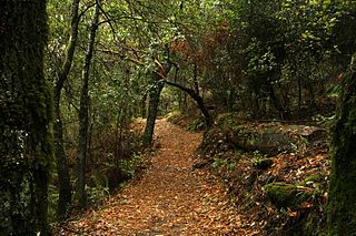
Claremont Canyon Regional Preserve is a small regional park mainly located in the city of Oakland, California, and administered by the East Bay Regional Park District. The park is named for the canyon in which it's situated, Claremont Canyon, out of which Claremont Creek flows on its way to its confluence with Temescal Creek. Originally, the canyon was named "Harwood's Canyon", then "Telegraph Canyon". The name was changed to Claremont by a developer of the nearby Claremont district.

Bolinas Lagoon is a tidal estuary, approximately 1,100 acres (4.5 km2) in area, located in the West Marin region of Marin County, California, United States, adjacent to the town of Bolinas. It is a part of the Greater Farallones National Marine Sanctuary and is considered to be among the possible landing spots of Sir Francis Drake on the west coast of North America in 1579.

Formed in 1972 by voter initiative, the Midpeninsula Regional Open Space District (MROSD) is a non-enterprise special district in the San Francisco Bay Area. It has acquired and preserved a regional green belt of open space land and provides opportunities for ecologically-sensitive public enjoyment and education.
Los Trancos Open Space Preserve is a 274-acre open space preserve, located in San Mateo and Santa Clara Counties, California, near Los Altos Hills, California. The preserve contains about 5 miles of hiking trails, of which 2.1 miles are open to equestrians, and none are open to bicycles.
Saratoga Gap Open Space Preserve is a 1540-acre regional park located near Saratoga Gap in the Santa Cruz Mountains of Santa Clara County, California. The preserve is owned and operated by the Midpeninsula Regional Open Space District. The preserve contains about 2 miles (3 km) of hiking trails, which are open to equestrians and bicycles.

Nairn Falls Provincial Park is a provincial park in British Columbia, Canada located on the Green River adjacent to British Columbia Highway 99 and the Canadian National Railway line just south of Pemberton and less than twenty minutes north of the resort town of Whistler. The 170 hectare park was established in 1966, shortly after the highway's opening, to protect and enhance visitor access to Nairn Falls, a double waterfall connected by a small canyon which throttles the flow of the Green River just before its accession to the lowlands of the Pemberton Valley and its confluence with the Lillooet River just above that river's estuary into Lillooet Lake.
Wildcat Canyon is a narrow linear valley just east of the Berkeley Hills in the San Francisco Bay Area, situated in Contra Costa County, California. The canyon is bounded on its east side by the San Pablo Ridge, and is drained by Wildcat Creek which runs northwest to its outlet in San Pablo Bay. Two minor lakes or ponds lie along the creek: Jewel Lake and Lake Anza. The latter was enlarged by the construction of a small dam in the mid-20th century. An active tectonic fault, the Wildcat Fault, runs the length of the canyon. Wildcat Canyon was named for the mountain lions which used to be fairly common in the area. The southern end of the canyon adjacent to the city of Berkeley was incorporated into Tilden Regional Park in the 1930s and remains a major recreation area for local residents. Another regional park, Wildcat Canyon Regional Park, is situated at the northern end of the canyon.
Bishop Ranch Regional Preserve (BRRP), also known as Bishop Ranch Regional Open Space Preserve is a 444-acre (1.80 km2) regional park on a ridge top at the edge of San Ramon, CA. It is near residential area, west of San Ramon Valley Road and South of Bollinger Canyon Road. Trails are steep and there are no facilities other than a trailhead. It is part of the East Bay Regional Parks system.
Cull Canyon Regional Recreation Area (CCRRA) is a regional park located in Castro Valley, Alameda County, California. It is part of the East Bay Regional Park District (EBRPD)system.
Huckleberry Botanic Regional Preserve is a 241 acres (0.98 km2) regional park and nature reserve in the Berkeley Hills, in the eastern East Bay region of the San Francisco Bay Area of California. It is within Alameda and Contra Costa Counties. It is a park within the East Bay Regional Parks District system. The Preserve is named after the California Huckleberry which grows abundantly within its habitat.

Radke Martinez Regional Shoreline (RMRS) is a regional park on the shoreline of Carquinez Strait in Martinez, located in northern Contra Costa County, California. Formerly known as the Martinez Regional Shoreline, it was renamed on December 6, 2016, in honor of the late Ted Radke and his late wife Kathy Radke.
San Pablo Ridge is a small mountain range in western Contra Costa County from Pinole to Orinda between Wildcat Canyon and San Pablo Canyon. The western flank is part of the Wildcat Creek watershed and the eastern flank is part of the San Pablo Creek watershed. To the west are the Berkeley Hills, and to the east, the Sobrante Ridge. The highest point on the San Pablo Ridge is Vollmer Peak, formerly called "Bald Peak", located near the point where it meets the Berkeley Hills at the head of Wildcat Canyon.
Bothin Marsh is a half acre wetlands in Marin County, California. Parts of the wetlands are in Bothin Marsh Open Space Preserve, a regional park.
Bell Canyon Park is a large open-space regional park located in the Simi Hills at the western end of the San Fernando Valley in West Hills, Los Angeles and Bell Canyon, California. Bell Creek, a primary tributary to the Los Angeles River, flows through the park with riparian zone vegetation along its natural banks. The geographic landmark Escorpión Peak is high above it to the south in adjacent El Escorpión Park.

Oakland Hills is the city neighborhoods lying within the eastern portion of Oakland, California. The northernmost neighborhoods were devastated by the Oakland firestorm of 1991.
Giant was an unincorporated community, now within Point Pinole Regional Shoreline, and annexed to Richmond in Contra Costa County, California. It lies at an elevation of 23 feet.
Monte Bello Open Space Preserve is a 3,133-acre (12.68 km2) open space preserve, located near Palo Alto in the Santa Cruz Mountains, in San Mateo and Santa Clara Counties, California, United States. The preserve encompasses the upper Stevens Creek watershed in the valley between Monte Bello Ridge and Skyline Ridge. "Monte Bello" means "beautiful mountain" in Italian, and refers to Black Mountain which is the highest part of Montebello Ridge. The straight valley of upper Stevens Creek is also the rift valley of the San Andreas Fault.

El Sereno Open Space Preserve is a park unit of the Midpeninsula Regional Open Space District located on the peak and slopes of 2580 ft. El Sereno mountain, a peak in the Santa Cruz Mountains. The preserve is located in Santa Clara County, California.

Long Ridge Open Space Preserve is a 2,035 acre open space preserve along Long Ridge in the Santa Cruz Mountains.
Foothills Open Space Preserve is a 212 acre open space preserve on Page Mill Road in Palo Alto, California. The land for the preserve was gifted to the Midpeninsula Regional Open Space District in 1974. The preserve's only trail is .4 miles and leads to a hilltop with views of the San Francisco Bay Area.

