
Contra Costa County is a county located in the U.S. state of California, in the East Bay of the San Francisco Bay Area. As of the 2020 United States Census, the population was 1,165,927. The county seat is Martinez. It occupies the northern portion of the East Bay region of the San Francisco Bay Area and is primarily suburban. The county's name refers to its position on the other side of the bay from San Francisco. Contra Costa County is included in the San Francisco–Oakland–Berkeley, CA Metropolitan Statistical Area.
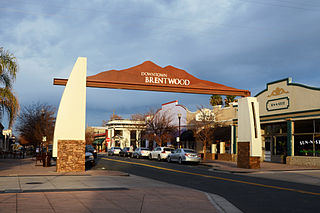
Brentwood is a city in Contra Costa County, California, United States. It is located in the East Bay region of the San Francisco Bay Area. The population is 66,854 as of 2022, an increase of 287% from 23,302 at the 2000 census.

Walnut Creek is a city in Contra Costa County, California, United States, located in the East Bay region of the San Francisco Bay Area, about 16 miles east of the city of Oakland. With a total population of 70,127 per the 2020 census, Walnut Creek serves as a vibrant hub for its neighboring cities because of its location at the junction of the highways from Sacramento and San Jose (I-680) and San Francisco/Oakland (SR-24), and its accessibility by BART. Its active downtown neighborhood features hundred-year-old buildings and extensive high-end retail establishments. The city shares its borders with Clayton, Lafayette, Alamo, Pleasant Hill, and Concord.

Mount Diablo is a mountain of the Diablo Range, in Contra Costa County of the eastern San Francisco Bay Area in Northern California. It is south of Clayton and northeast of Danville. It is an isolated upthrust peak of 3,849 feet, visible from most of the San Francisco Bay Area. Mount Diablo appears from many angles to be a double pyramid and has many subsidiary peaks. The largest and closest is North Peak, the other half of the double pyramid, which is nearly as high in elevation at 3,557 feet (1,084 m), and is about one mile northeast of the main summit.

The East Bay Regional Park District (EBRPD) is a special district operating in Alameda County and Contra Costa County, California, within the East Bay area of the San Francisco Bay Area. It maintains and operates a system of regional parks which is the largest urban regional park district in the United States. The administrative office is located in Oakland.
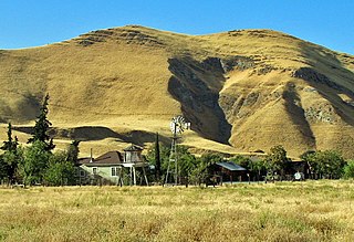
Morgan Territory is an historic ranching area on the east side of Mount Diablo in San Francisco East Bay's Contra Costa County. It was named after Anglo-American pioneer Jeremiah Morgan, a migrant from Alabama and Iowa who acquired 2000 acres and developed a ranch here, starting in 1857.

Robert John Walker was an American photographer and environmental activist based in San Francisco, California. As an activist from 1982 to 1992, he was associated with more than a dozen Bay Area conservation organizations and as a photographer for the East Bay Regional Park District. He contributed to expansion of public protection of important areas of Mt. Diablo and nearby areas.

John Albert Nejedly was a district attorney and Republican state senator in California who represented Contra Costa County from 1958 to 1980.
The Black Diamond Mines Regional Preserve is a 6,000-acre (2,400 ha) park located north of Mount Diablo in Contra Costa County, California under the administration of the East Bay Regional Park District (EBRPD). The district acquired the property in 1973. The preserve contains relics of 3 mining towns, former coal and sand mines, and offers guided tours of a former sand mine. The 60 miles (97 km) of trails in the Preserve cross rolling foothill terrain covered with grassland, California oak woodland, California mixed evergreen forest, and chaparral.
Castle Rock Regional Recreation Area is a 18,000 acres (73 km2) regional park of the East Bay Regional Park District. It is located in Contra Costa County, in the East Bay region of northern California.
Brushy Peak Regional Preserve is a regional park that is part of the East Bay Regional Parks (EBRPD) and the Livermore Area Recreation and Park District (LARPD) systems. It is located in unincorporated land in Alameda County, just north of Livermore, California.
Morgan Territory Regional Preserve is a regional park in Contra Costa County, California. Located east of Clayton and north of Livermore, California, bordering on Mt. Diablo State Park, it is part of the East Bay Regional Park District (EBRPD). The preserve was founded in 1975 with fewer than 1,000 acres (400 ha), but EBRPD has gradually acquired more property, and, since 2015, the preserve encompasses 5,230 acres (2,120 ha). The main access roads run from Livermore and Clayton.
Round Valley Regional Preserve is a regional park just outside Antioch, CA and Brentwood, CA that is part of the East Bay Regional Parks (EBRPD) system. It is on Marsh Creek Road, approximately 5.2 miles (8.4 km) west of the intersection with Vasco Road. The park was begun in 1988, when Jim Murphy sold 700 acres (280 ha) of land to EBRPD. The land originally belonged to Mr. Davis' grandfather Thomas Murphy, an Irish immigrant, who had purchased the land in 1878 for a farming and ranching operation. The preserve has since expanded to encompass 1,911 acres (773 ha).
Sycamore Valley Regional Open Space Preserve is a regional park in Contra Costa County, California, outside of Danville, California, United States that is part of the East Bay Regional Parks (EBRPD) system.
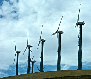
The Altamont Pass wind farm is located in the Altamont Pass of the Diablo Range in Northern California. It is one of the earliest wind farms in the United States. The first wind turbines were placed on the Altamont in the early 1980s by Fayette Manufacturing Corporation on land owned by cattle rancher Joe Jess. The wind farm is composed of 4930 relatively small wind turbines of various types, making it at one time the largest wind farm in the world in terms of capacity. Altamont Pass is still one of the largest concentration of wind turbines in the world, with a capacity of 576 megawatts (MW), producing about 125 MW on average and 1.1 terawatt-hours (TWh) yearly. They were installed after the 1970s energy crisis in response to favorable tax policies for investors.

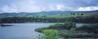
The Los Vaqueros Reservoir and watershed is located in the northern Diablo Range, within northeastern Contra Costa County, northern California. It was completed by the Contra Costa Water District (CCWD) in 1998 to improve the quality of drinking water for its 550,000 customers in Central and Eastern Contra Costa County. The reservoir is accessible via Vasco Road, a road which connects Brentwood and Livermore.

Mount Diablo Silverado Council was a local council of the Scouts BSA and was one of six councils that serves the San Francisco Bay area in California. The council's office was located in Pleasant Hill, California. It served chartered organizations and BSA units in Contra Costa County, Lake County, Napa County, Solano County, and the cities of Albany and Berkeley in northern Alameda County. The council is located in BSA Western Region Area III. It merged with Alameda Council #021 and San Francisco Bay Area Council #028 in June 2020 to form the Golden Gate Area Council #023.

Rancho Cañada de los Vaqueros was a 17,760-acre (71.9 km2) Mexican land grant mostly in present day eastern Contra Costa County, California, and partially into northeastern Alameda County, California. Los Vaqueros Reservoir, located between Livermore and Brentwood in the Diablo Range, is on and named for the former rancho. Vasco Road passes through the site.
Marsh Creek is a stream in east Contra Costa County, California in Northern California which rises on the eastern side of Mount Diablo and flows 30 miles (48 km) to the Sacramento–San Joaquin River Delta at Oakley, California, near Big Break Regional Shoreline. The creek flows through Marsh Creek State Park (California), where water is impounded to form Marsh Creek Reservoir, then through the city of Brentwood, California.
Vasco Road is a roadway over the Diablo Range that connects Livermore and Brentwood, California. Although it is not part of the California State Highway system, it is the principal north–south commuter route serving eastern Alameda and Contra Costa counties. The two counties are each responsible for maintaining the portion of the road within their boundaries.
