
San Francisco Bay is a shallow estuary in the US state of California. It is surrounded by a contiguous region known as the San Francisco Bay Area, and is dominated by the large cities of San Jose, San Francisco and Oakland.
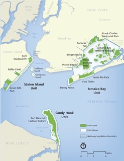
Gateway National Recreation Area is a 26,607-acre (10,767 ha) U.S. National Recreation Area in New York City and Monmouth County, New Jersey. It provides recreational opportunities that are not commonly found in a dense urban environment, including ocean swimming, bird watching, boating, hiking and camping. Ten million people visit Gateway annually.

The East Bay Regional Park District (EBRPD) is a special district operating in Alameda County and Contra Costa County, California, within the East Bay area of the San Francisco Bay Area. It maintains and operates a system of regional parks which is the largest urban regional park district in the United States. The administrative office is located in Oakland.

San Diego Bay is a natural harbor and deepwater port located in San Diego County, California near the U.S.–Mexico border. The bay, which is 12 miles (19 km) long and 1 to 3 miles wide, is the third largest of the three large, protected natural bays on California's entire 840 miles (1,350 km) long coastline after San Francisco Bay and Humboldt Bay. The highly urbanized land adjacent to the bay includes the city of San Diego and four other cities: National City, Chula Vista, Imperial Beach and Coronado.
The California State Coastal Conservancy is a state agency in California established in 1976 to enhance coastal resources and public access to the coast. The CSCC is part of the California Natural Resources Agency.
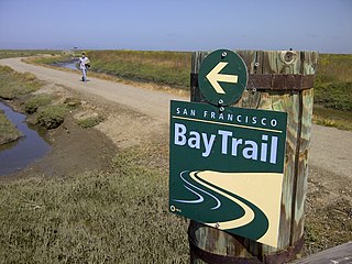
The San Francisco Bay Trail is a bicycle and pedestrian trail that when finished will allow continuous travel around the shoreline of San Francisco Bay. As of 2020, 356 miles (573 km) of the trail have been completed. When finished, the trail will be over 500 miles (800 km) of paved and gravel paths, bike lanes, and sidewalks, linking 47 cities across nine counties and crossing seven toll bridges. It is a project of the Association of Bay Area Governments (ABAG) and the Metropolitan Transportation Commission (MTC), in collaboration with other agencies, private companies, non-profit organizations, and advocacy groups.
The Bay Area Open Space Council is a network of 65 nonprofits and public agencies that serve tens of millions of people each year in the San Francisco Bay Area. Founded in 1990 by a group of land conservation practitioners, the Open Space Council provides information, tools, and connections for its members. Examples of member organizations include land conservation organizations, land trusts, water districts, and park districts.

The Golden Gate National Recreation Area (GGNRA) is a U.S. National Recreation Area protecting 82,027 acres (33,195 ha) of ecologically and historically significant landscapes surrounding the San Francisco Bay Area. Much of the park is land formerly used by the United States Army. GGNRA is managed by the National Park Service and is the most visited unit of the National Park system in the United States, with more than 15 million visitors a year. It is also one of the largest urban parks in the world, with a size two-and-a-half times that of the consolidated city and county of San Francisco.
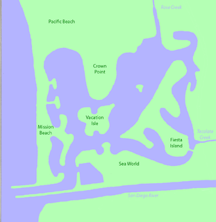
Mission Bay is a human-made saltwater bay located south of the Pacific Beach community of San Diego, California created from approximately 2,000 acres of historical wetland, marsh, and saltwater bay habitat. The bay is part of the recreational Mission Bay Park, the largest man-made aquatic park in the country, consisting of 4,235 acres (17.14 km2), approximately 46% land and 54% water. The combined area makes Mission Bay Park the ninth largest municipally-owned park in the United States.

McLaughlin Eastshore State Park is a state park and wildlife refuge along the San Francisco Bay shoreline of the East Bay between the cities of Richmond, Albany, Berkeley, Emeryville, and Oakland. It encompasses remnant natural wetlands, restored wetlands, as well as landfill west of the Eastshore Freeway. Its shoreline is 8.5 miles (13.7 km) long, and its total area is 1,854 acres (750 ha), which includes both tidelands and uplands. Originally named just Eastshore State Park, it was renamed in October 2012 to honor Save the Bay founder Sylvia McLaughlin. Prior to 2013, it was jointly managed by the California State Parks and East Bay Regional Park District (EBRPD). The state agency and EBRPD executed a 30-year agreement for EBRPD to manage the park.

Carquinez Strait Regional Shoreline is a regional park, part of the East Bay Regional Park District system, located in northwestern Contra Costa County, California.

Elkhorn Slough is a 7-mile-long (11 km) tidal slough and estuary on Monterey Bay in Monterey County, California. The community of Moss Landing and the Moss Landing Power Plant are located at the mouth of the slough on the bay.

The Los Vaqueros Reservoir is located in the northern Diablo Range, within northeastern Contra Costa County, northern California. It was completed by the Contra Costa Water District (CCWD) in 1998 to improve the quality of drinking water for its 550,000 customers in Central and Eastern Contra Costa County, and the reservoir is accessible via Vasco Road, a road which connects Brentwood and Livermore.
The Water Resources Development Act of 1996 is part of Pub.L. 104–303, was enacted by Congress of the United States on October 12, 1996. Most of the provisions of WRDA 1996 are administered by the United States Army Corps of Engineers.
The Dotson Family Marsh, formerly Breuner Marsh, is a 238-acre regional park on San Pablo Bay in the East San Francisco Bay Area city of Richmond, California, In 2009 the East Bay Regional Parks District acquired the Breuner Marsh site, adding it to Point Pinole Regional Shoreline. A habitat restoration plan for 60 acres of wetlands and 90 acres of California coastal prairie was subsequently approved.
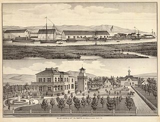
Roberts Landing was a settlement in Alameda County, California, now incorporated into the town of San Leandro. It is located at the mouth of San Lorenzo Creek on San Francisco Bay just west of the community of San Lorenzo. In the 19th century, it had warehouses and a wharf, and was used by farmers to ship their produce to the city of San Francisco. From 1906 to 1964, it was the site of an explosives manufacturing plant operated by the Trojan Powder Company. Following the plant's closure, the site was decontaminated. After protracted discussions, part was made into a housing development while a larger part was made an open space that is now also called the San Leandro Shoreline Marshlands.

The California Coastal Trail, or CCT, is an environmental project by the California Coastal Conservancy, an organization developed to enhance coastal resources and promote access to the shore in 2001.

Water trails are marked routes on navigable waterway such as rivers, lakes, canals and coastlines for recreational use. They allow access to waterways for non-motorized boats and sometimes motorized vessels, innertubes, and other craft. Water trails not only require suitable access points and take-outs for exit but also provide places ashore to camp and picnic, and other facilities for boaters.
Oyster Bay Regional Shoreline is a park in San Leandro, California, part of the East Bay Regional Park District (EBRPD). It is located along the eastern shore of San Francisco Bay directly to the south of Oakland International Airport. The property was originally used as a landfill for 37 years, until it was filled to capacity in 1977, when it was capped with a clay cover. EBRPD bought the property in 1980, intending to use it as a park.

Open spaces in urban environments, such as parks, playgrounds, and natural areas, can provide many health, cultural, recreational, and economic benefits to the communities nearby. However, access to open spaces can be unequal for people of different incomes. In California's two largest metropolitan regions, Los Angeles County in Southern California and the Bay Area in Northern California, access to green space and natural areas varies with the predominate races and classes of the communities. This also holds true in San Diego County in Southern California. Both expanding urbanization and diminishing funding for open space tend to widen these gaps in accessibility. Because open space is associated with various mental and physical benefits, a lack of access to it can pose health consequences. However, more research is needed to determine whether such environmental inequalities translate into long-term health inequalities, and, if so, how.


