 Along Canyon Road
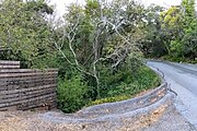 Crossing under Canyon Road
 At the California–Grove Storm Station
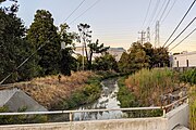 At Rollins Road, approaching the bay
 Looking upstream from Old Bayshore Highway
 Slough entering the bay
| Easton Creek | |
|---|---|
 Easton Creek channel as it approaches the bay | |
 Location of the mouth of Easton Creek in California | |
| Location | |
| Country | United States |
| State | California |
| Region | San Mateo County |
| City | Burlingame |
| Physical characteristics | |
| Source | |
| • location | San Mateo County, California |
| Mouth | |
• elevation | 29 ft (8.8 m) |
Easton Creek is a short eastward-flowing stream whose watershed originates in Burlingame's foothills in San Mateo County, California, United States. [1] The creek runs south of the Mills Creek and north of the Sanchez Creek watercourses. [1]
Contents
The creek is predominantly underground, with storm drains through the hills and residential flatlands of Burlingame, roughly following Canyon Road and Easton Drive. Starting at the Caltrain tracks, towards the former marshlands adjacent to the San Francisco Bay, it is culverted or channelized into the bay. [1]


