Cerrito Creek

Last updated
Cerrito Creek
Cerrito Creek at Ohlone Greenway.jpg
Cerrito Creek passing under Ohlone Greenway and BART tracks
Relief map of California.png
Red pog.svg
Location of the mouth of Cerrito Creek in California
Etymology"cerrito", Spanish for little hill, referring to Albany Hill]
Location
Country United States
State California
Region Contra Costa County, Alameda County
Cities Albany, El Cerrito, Berkeley, Kensington, Richmond
Physical characteristics
SourceBerkeley Hills
  locationabove Arlington Avenue, Berkeley
  coordinates 37°54′7″N122°16′34″W / 37.90194°N 122.27611°W / 37.90194; -122.27611 [1]
  elevation500 ft (150 m)
2nd sourceBerkeley Hills
  locationabove Arlington Avenue, Kensington
Mouth San Francisco Bay
  location
south of Pt. Isabel, north of Albany Hill Richmond
  coordinates
37°53′49″N122°18′43″W / 37.89694°N 122.31194°W / 37.89694; -122.31194 Coordinates: 37°53′49″N122°18′43″W / 37.89694°N 122.31194°W / 37.89694; -122.31194 [1]
  elevation
0 ft (0 m)
Length2 mi (3.2 km) [1]
Basin features
Tributaries 
  left North Fork Cerrito Creek (California), Unnamed creeks north of Fairmount Ave. (California)
  right Middle/Blackberry
BSicon fCONTgq.svg
BSicon fTEEa.svg
BSicon fCONTfq.svg
Ohlone Greenway
BSicon uhCONTgq.svg
BSicon MSTRq.svg
BSicon uhSTRq.svg
BSicon fSTR.svg
BSicon uhCONTfq.svg
Bart-logo.svg
BSicon fKBHFe.svg
BSicon fKBHFaq.svg
BSicon fSTR+r.svg
BSicon MASKa.svg
BSicon MSTRq.svg
BSicon RP4oWq.svg
El Cerrito Plaza
BSicon fSTR.svg
BSicon WASSER.svg
BSicon fSTR.svg
BSicon MASKe.svg
BSicon MSTRq.svg
BSicon RP4oWq.svg
BSicon fLSTR.svg
BSicon RP4q.svg
BSicon MASKa.svg
BSicon RP4q.svg
BSicon RP4oWq.svg
BSicon fHST.svg
BSicon WASSER.svg
Creekside Park
BSicon fSTR.svg
BSicon lGIPl.svg
BSicon WASSER.svg
Albany Hill
BSicon fSTRl.svg
BSicon fhKRZWaeq.svg
BSicon fexSTR+r.svg
BSicon fCONTgq.svg
BSicon fhKRZWaeq.svg
BSicon fSTRq.svg
BSicon fexENDEe.svg
BSicon fCONTfq.svg
San Francisco Bay Trail

Cerrito Creek is one of the principal watercourses running out of the Berkeley Hills into San Francisco Bay in northern California. It is significant for its use as a boundary demarcation historically, as well as presently. In the early 19th century, it separated the vast Rancho San Antonio to the south from the Castro family's Rancho San Pablo to the north. Today, it marks part of the boundary between Alameda County and Contra Costa County. The main stem, running through a deep canyon that separates Berkeley from Kensington, is joined below San Pablo Avenue by a fan of tributaries, their lower reaches mostly in culverts. The largest of these is Middle or Blackberry Creek, a southern branch.

Contents

The creek is named for Albany Hill, formerly called Cerrito de San Antonio, a prominent (elevation 294 ft.) isolated hill on the shoreline of San Francisco Bay in Albany (The hill is now some distance inland due to Bay fill). Cerrito Creek, joined by a fan of other small creeks, formerly meandered to the Bay through a large marsh just north of the hill.

History

The creek played a part in history larger than its size. Because it divided the two land-grant ranches, it became the division between Alameda and Contra Costa counties. With Alameda County settled more densely in the early 20th-century boom that followed the San Francisco earthquake, the area just north of the county line became the home of jazz joints, gambling, brothels and other pursuits requiring a light hand from the law. This lasted until a post–World War II reform movement in the City of El Cerrito.

The marsh at the creek's mouth also played a curious bit part in history. Regarding such wetlands as useless, 19th- and 20th-century settlers set out to fill it, locating a slaughterhouse and dump there. An early 20th-century typhoid scare, however, led to closing of the dump. This left Berkeley, booming with new residents after the great San Francisco earthquake, without a place for its garbage. A new dump south of the hill was quickly arranged, in what is now the City of Albany. Women of that unincorporated area were upset, but they lacked the vote. One morning, they sought to turn back the garbage wagon with guns. Although they gave up when the sheriff ordered them to disperse, male residents who had formerly resisted incorporation then quickly voted to incorporate the city of Ocean View—soon renamed Albany to avoid confusion with the Oceanview district of Berkeley.

The marsh was eventually filled—rubble from dynamite making and quarrying on Albany Hill contributed. The creek was confined to a small channel, and in 1969 the City of El Cerrito built flood basins north of the creek in Creekside Park, a new park created as part of renewing the down-at-heel, flood-prone neighborhood that had grown up in the filled marsh. In 1953, the head of Stege Sanitary District wrote, "As late as 1920, records show a small lake bordered by marsh south of 'County Road No. 4' now Central, near Belmont. Nothing appears to justify use of this area for dwellings; and, the character of construction permitted in the past has involved a succession of unwise buyers of homes in losses and disappointments only partly compensated by sale to some newer victim."

Tides still rise and fall inland as far as Albany's and El Cerrito's Creekside Parks, respectively south and north of the creek. When a high tide coincides with winter storm runoff (greatly increased by the city's impermeable surfaces), the former marsh area can flood.

Restoration

Unsuccessful efforts to bring a portion of the creek out of a pipe when a former lumberyard became Albany Middle School in the 1990s led indirectly to the formation of Friends of Five Creeks, a citizens group. Volunteers with this group have worked since 1996 on this and other local creeks, principally removing invasives, planting natives, and installing amenities including signs and benches.

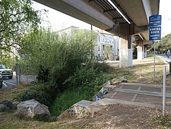
The City of El Cerrito is committed to a long-term plan to "daylight" the still-culverted reaches of the creek at the south edge of El Cerrito Plaza, between San Pablo Avenue and the Ohlone Greenway (regional pedestrian/bicycle route under the BART tracks). The cities of Albany and El Cerrito have adopted a long-term plan for a pedestrian-bicycle route mostly along the creek, connecting the Ohlone Greenway to the Bay Trail. This plan is gradually being carried out.

Friends of Five Creeks established some natives and placed a litter can at the short reach exposed at the Ohlone Greenway, but these plantings have repeatedly been devastated by maintenance workers. Between Talbot and Kains, adjacent to the El Cerrito Plaza shopping center, a state grant to the City of El Cerrito led to the channelized creek being re-contoured in 2003, giving it a more natural flow pattern, native vegetation, and a creekside trail. This project, maintained and improved by Friends of Five Creeks, has been successful.

The channelized south bank between San Pablo Avenue and Pierce Street was "torn up" by a sewer replacement project in 1998–99 Pierce Street. [2] As part of that project, the Urban Creeks Council was instrumental in having the old sewer pipe broken up so that steelhead could again access Middle Creek. (These anadromous fish have been observed in the creek but there is no evidence of recent successful reproduction.) The City of Albany used mitigation funds to establish native vegetation on the north bank, but the project was rapidly re-invaded by invasives such as blackberry, Cape ivy, and morning glory when that money ran out.

Friends of Five Creeks began intensive work between San Pablo and Pierce in 2000, beginning on the north bank at Pacific East Mall, carrying out restoration required in the mall's use permit. Tasks included removing fencing, building a creekside trail, removing evergreen thornless blackberries that formed thickets more than 10 feet (3.0 m) high and spanned the creek, and establishing native vegetation. This revegetation has been reasonably successful, although the mall's maintenance contractors sprayed much of the grassland areas with herbicide, and these native grasses have never been re-established. The mall was required to re-plant shrubs, carry out long-promised pollution reduction, and improve its maintenance as a result of this incident. [3]

Since 2004, Friends of Five Creeks volunteers have focused on the reach from Adams Street downstream to Pierce Street. The largest task continues to be removing evergreen thornless blackberry, which quickly clogs the creek and increases flooding. With help from both cities, volunteers also have removed other invasives, planted natives, and installed amenities such as benches, signs, and a table in the Creekside Parks facing each other in Albany and El Cerrito. [4] Parkland extends to most of Albany Hill, with grasslands, a willow grove at the mouth of Middle Creek, and mature oak forest on the steep north face of the hill. Thus this complex is an unusual island of urban green space and habitat surrounded by city. Wildlife includes sticklebacks, Pacific chorus frogs, herons, egrets, kingfishers, ducks, hawks, raccoons, and deer.

See also

Related Research Articles

<span class="mw-page-title-main">Albany, California</span> City in California, United States

Albany is a city on the east shore of San Francisco Bay in northwestern Alameda County, California. The population was 20,271 at the 2020 census.

<span class="mw-page-title-main">El Cerrito, California</span> City in California, United States

El Cerrito is a city in Contra Costa County, California, United States, and forms part of the San Francisco Bay Area. It has a population of 25,962 according to the 2020 census. El Cerrito was founded by refugees from the 1906 San Francisco earthquake. It was incorporated in 1917 as a village with 1,500 residents. As of the census in 2000, there were 23,171 people, 10,208 households and 5,971 families in the city.

Solano Avenue in Berkeley and Albany, California is a two-mile (3.2 km) long east-west street. Solano Avenue is one of the larger shopping districts in the Berkeley area. Businesses along Solano Avenue cover a wide range, including grocery stores, coffee shops, drugstores, bookstores, antique dealers, apparel outlets, ethnic restaurants and a movie theater.

<span class="mw-page-title-main">El Cerrito Plaza station</span> Rapid transit station in San Francisco Bay Area

El Cerrito Plaza station is a Bay Area Rapid Transit (BART) station in El Cerrito, California, located adjacent to the El Cerrito Plaza shopping center. It primarily serves southern El Cerrito, northern Albany, and Kensington, along with nearby portions of Berkeley and Richmond. Nearly identical in form to El Cerrito del Norte station, El Cerrito Plaza station has two side platforms serving the line's two elevated tracks, with a fare lobby underneath. The Ohlone Greenway runs through the station area.

<span class="mw-page-title-main">El Cerrito Plaza (shopping center)</span> Shopping mall in California, United States

El Cerrito Plaza is a shopping center in El Cerrito, California, a suburb in the San Francisco Bay Area.

<span class="mw-page-title-main">Strawberry Creek</span> River in California, United States

Strawberry Creek is the principal watercourse running through the city of Berkeley, California. Two forks rise in the Berkeley Hills of the California Coast Ranges, and form a confluence at the campus of the University of California, Berkeley. The creek then flows westward across the city to discharge into San Francisco Bay.

<span class="mw-page-title-main">Albany Hill</span>

Albany Hill is a prominent hill along the east shore of San Francisco Bay in the city of Albany, California. Geologically, the hill is predominantly Jurassic sandstone, carried to the western edge of North America on the Pacific Plate and scraped off there in the course of subduction. Albany Hill is part of a range of hills uplifted long before today's Berkeley Hills. These hills include Fleming Point and Point Isabel, Brooks Island, the Potrero San Pablo, and the hills across San Pablo Strait.

<span class="mw-page-title-main">California and Nevada Railroad</span>

The California and Nevada Railroad was a 3 ft narrow gauge steam railroad which ran in the East Bay of the San Francisco Bay Area in the late 19th century. It was incorporated on March 25, 1884. J.S. Emery was listed as the railroad's president - the present day city of Emeryville is named after him. On March 1, 1885 the track was completed between Oakland and San Pablo via Emeryville. The track to Oak Grove was completed on January 1, 1887.

<span class="mw-page-title-main">Ohlone Greenway</span>

The Ohlone Greenway is a 4.5-mile (7.2 km) pedestrian and bicycle path in the East Bay region of the San Francisco Bay Area.

<span class="mw-page-title-main">Codornices Creek</span> River in California, United States

Codornices Creek, 2.0 miles (3.2 km) long, is one of the principal creeks which runs out of the Berkeley Hills in the East Bay area of the San Francisco Bay Area in California. In its upper stretch, it passes entirely within the city limits of Berkeley, and marks the city limit with the adjacent city of Albany in its lower section. Before European settlement, Codornices probably had no direct, permanent connection to San Francisco Bay. Like many other small creeks, it filtered through what early maps show as grassland to a large, northward-running salt marsh and slough that also carried waters from Marin Creek and Schoolhouse Creek. A channel was cut through in the 19th Century, and Codornices flows directly to San Francisco Bay by way of a narrow remnant slough adjacent to Golden Gate Fields racetrack.

Richmond Annex or The Annex is a neighborhood in southeastern Richmond, California. It is mostly residential and located between San Pablo Avenue/El Cerrito to the east, San Francisco Bay to the west, Central Avenue/Cerrito Creek/Albany Hill/Albany/Alameda County to the south, and Potrero Avenue/Pullman to the north. Carlson Boulevard is the main thoroughfare through the annex, connecting downtown Richmond with downtown El Cerrito.

Point Isabel is a promontory on the eastern shore of San Francisco Bay in the Richmond Annex neighborhood of Richmond, United States.

<span class="mw-page-title-main">Baxter Creek</span> River in California, United States

Baxter Creek or Stege Creek, is a three-branch creek in Richmond and El Cerrito, California, United States, forming the Baxter Creek watershed. The creek has three sources and flows from the Berkeley Hills to Stege Marsh and the San Francisco Bay. The Baxter Creek watershed at-large has 10 sources.

<span class="mw-page-title-main">Garrity Creek</span> River in California, United States

Garrity Creek is a 3.0-mile-long (4.8 km) creek in Richmond, California's Hilltop neighborhood. It runs into San Pablo Bay. It is sometimes called Hilltop Creek.

<span class="mw-page-title-main">Hydrography of the San Francisco Bay Area</span> Waterways and watersheds draining into the bay or Pacific Ocean

The Hydrography of the San Francisco Bay Area is a complex network of watersheds, marshes, rivers, creeks, reservoirs, and bays predominantly draining into the San Francisco Bay and Pacific Ocean.

<span class="mw-page-title-main">Marin Creek</span> River in California, United States

Marin Creek is a creek tributary of Codornices Creek in northwestern Alameda County, California. The lower stretch of Marin Creek is also known as Village Creek.

<span class="mw-page-title-main">Pinole Creek</span> River in California, United States

Pinole Creek is a stream in western Contra Costa County, in the East Bay region of the San Francisco Bay Area, California.

<span class="mw-page-title-main">Pacific East Mall</span> Shopping mall in California, United States

Pacific East Mall is an Asian mall in Richmond, California. It is owned by Pacific Infinity Company Incorporated.

Friends of Five Creeks is a regional community volunteer organization founded in 1996 by Sonja Wadman originally dedicated to the stewardship of creeks in northern Alameda County and western Contra Costa, California, United States. Education about wildlife and restoration is also a major facet of the FFC's mission.

Middle Creek is a major tributary of Cerrito Creek in Albany, California.

References