
Richmond is a city in western Contra Costa County, California, United States. The city was incorporated on August 3, 1905, and has a city council. Located in the San Francisco Bay Area's East Bay region, Richmond borders San Pablo, Albany, El Cerrito and Pinole in addition to the unincorporated communities of North Richmond, Hasford Heights, Kensington, El Sobrante, Bayview-Montalvin Manor, Tara Hills, and East Richmond Heights, and for a short distance San Francisco on Red Rock Island in the San Francisco Bay.
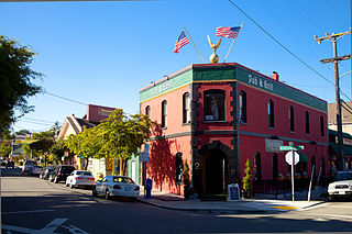
Point Richmond, also sometimes referred to locally as The Point, is a neighborhood in Richmond, California, United States, near the eastern end of the Richmond-San Rafael Bridge, between Interstate 580 and the San Francisco Bay.
McLaughlin Eastshore State Park is a state park and wildlife refuge along the San Francisco Bay shoreline of the East Bay between the cities of Richmond, Albany, Berkeley, Emeryville, and Oakland. It encompasses remnant natural wetlands, restored wetlands, as well as landfill west of the Eastshore Freeway. Its shoreline is 8.5 miles (13.7 km) long, and its total area is 1,854 acres (750 ha), which includes both tidelands and uplands. Originally named just Eastshore State Park, it was renamed in October 2012 to honor the late Save the Bay founder Sylvia McLaughlin, who, along with the late Dwight Steele of Citizens for Eastshore Park, drove the establishment of the park. Prior to 2013, it was jointly managed by the California State Parks and East Bay Regional Park District (EBRPD). The state agency and EBRPD executed a 30-year agreement for EBRPD to manage the park.

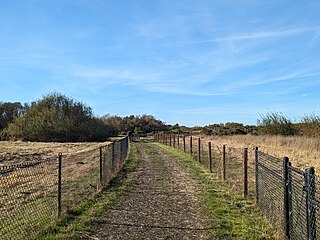
Point Isabel Regional Shoreline in Richmond, California, is operated by East Bay Regional Park District, and is a multi-use park for joggers, windsurfers, kayakers, photographers, picnickers, and people walking dogs. It has access for pedestrians and via public transit, private vehicles, and bikes. It also features a concession offering food for people and grooming for pets. A longtime community organization and nonprofit, Point Isabel Dog Owners and Friends (PIDO), is active in the maintenance and improvement of the park.
Point Isabel is a promontory on the eastern shore of San Francisco Bay in the Richmond Annex neighborhood of Richmond, United States.
Baxter Creek or Stege Creek, is a three-branch creek in Richmond and El Cerrito, California, United States, forming the Baxter Creek watershed. The creek has three sources and flows from the Berkeley Hills to Stege Marsh and the San Francisco Bay. The Baxter Creek watershed at-large has 10 sources.

Hayward Regional Shoreline is a regional park located on the shores of the San Francisco Bay in Hayward, California. It is part of the East Bay Regional Parks system. The 1,713-acre (693 ha) park extends to the shores of San Lorenzo. Part of the park is former commercial salt flats purchased in 1996. A former landfill, now capped with soil and plants, is located in the park. The park includes the 250-acre (100 ha) tidal wetland, Cogswell Marsh, and the 364-acre (147 ha) Oro Loma Marsh. Located to the south of the park is the Hayward Shoreline Interpretive Center, which provides information on the Bay shore habitats. The San Francisco Bay Trail runs through the park, which connects the park with San Lorenzo Creek.
Fluvius Innominatus or Central Creek is a stream in Richmond and El Cerrito, California, in western Contra Costa County. There is one main source and a secondary unnamed tributary. The creek drains into Hoffman Marsh and then flows into the bay through Point Isabel Regional Shoreline's Hoffman Channel. However, before the area was developed and as early as 1899 the creek had as many as 11 sources which stretched far higher into the Berkeley Hills.
Castro Creek is a creek in Richmond, California, in the western part of the city adjacent to the Chevron Oil Refinery. Wildcat Creek drains into it directly and though other Wildcat Marsh tributaries into Castro Cove of San Pablo Bay. The creek drains from the drainage basin of the surrounding area and was once part of the channel that separated the island of Point Richmond with the mainland.

Castro Cove is a "portion of the San Pablo Bay" in Richmond, California located between Point San Pablo and the confluence of Wildcat Creek into Castro Creek.
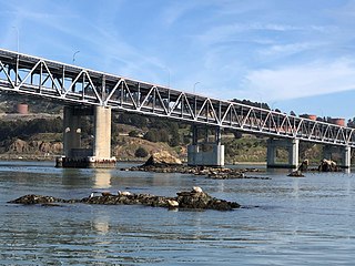
The Castro Rocks are several rocks in Richmond, California, protruding from the waters in San Francisco Bay between Castro Point and Red Rock Island. The rocks lie almost directly under the Richmond-San Rafael Bridge (I-580).

Point San Pablo Harbor is a marina and small community at the far end of Point San Pablo in San Pablo Bay, within Richmond, in Contra Costa County, California. It is located at 1900 Stenmark Drive, Richmond CA 94801.
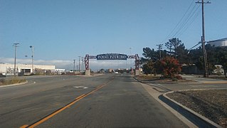
Point Potrero is a point in San Pablo Bay forming a cape and hugging the Potrero Hills in Richmond, California.
San Pablo Peninsula is a peninsula in western Richmond, between San Pablo Bay and San Rafael Bay, in southwestern Contra Costa County, California.
Stege Marsh, also known as the South Richmond Marshes, is a tidal marshland wetlands area in Richmond, California in western Contra Costa County.
Hoffman Marsh is a wetlands on San Francisco Bay in Richmond, California. The marsh has been protected within Eastshore State Park, and adjacent to Point Isabel Regional Shoreline. The marsh is an important nesting ground for wildfowl and stopping ground on the Pacific Flyway, as it is one of only a handful of undestroyed wetlands in the Bay Area. It borders Point Isabel Regional Shoreline and Interstate 80.
The Lauritzen Canal is a shipping waterway which is part of the larger Port of Richmond in Richmond, California. It was dredged out of the former expanse of the now atrophied Castro Cove wetlands of the West Richmond Watershed. It was created for shipbuilding yards in World War II. Today is serves as part of the operation of the Port of Richmond for largely petrochemical, liquid bulk, and vehicle imports.

Stege, founded in 1876, was an unincorporated community in western Contra Costa County, California, United States. The town has now been annexed and absorbed by the cities of Richmond and El Cerrito, California. It was located on the Southern Pacific Railroad 1.5 miles (2.4 km) south-southeast of downtown Richmond, at an elevation of 23 feet. The site is now located in the area known as the Richmond Annex, at coordinates: 37°55′00″N122°19′38″W.
The Chevron Richmond Refinery is a 2,900-acre (1,200 ha) petroleum refinery in Richmond, California, on San Francisco Bay. It is owned and operated by Chevron Corporation and employs more than 1,200 workers, making it the city's largest employer. The refinery processes approximately 240,000 barrels (38,000 m3) of crude oil a day in the manufacture of petroleum products and other chemicals. The refinery's primary products are motor gasoline, jet fuel, diesel fuel and lubricants.

The Richmond Long Wharf is a major tanker terminal and port facility in Richmond, California.