
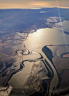
The Guadalupe River mainstem is an urban, northward flowing 14 miles (23 km) river in California whose much longer headwater creeks originate in the Santa Cruz Mountains. The river mainstem now begins on the Santa Clara Valley floor when Los Alamitos Creek exits Lake Almaden and joins Guadalupe Creek just downstream of Coleman Road in San Jose, California. From here it flows north through San Jose, where it receives Los Gatos Creek, a major tributary. The Guadalupe River serves as the eastern boundary of the City of Santa Clara and the western boundary of Alviso, and after coursing through San José, it empties into south San Francisco Bay at the Alviso Slough.
Coyote Creek is a river that flows through the Santa Clara Valley in Northern California. Its source is on Mount Sizer, in the mountains east of Morgan Hill. It eventually flows into Anderson Lake in Morgan Hill and then northwards through Coyote Valley to San Jose, where it empties into San Francisco Bay.

The San Diego River is a river in San Diego County, California. It originates in the Cuyamaca Mountains northwest of the town of Julian, then flows to the southwest until it reaches the El Capitan Reservoir, the largest reservoir in the river's watershed at 112,800 acre-feet (139,100,000 m3). Below El Capitan Dam, the river runs west through Santee and San Diego. While passing through Tierrasanta it goes through Mission Trails Regional Park, one of the largest urban parks in America.

Malibu Creek is a year-round stream in western Los Angeles County, California. It drains the southern Conejo Valley and Simi Hills, flowing south through the Santa Monica Mountains, and enters Santa Monica Bay in Malibu, California. The Malibu Creek watershed drains 109 square miles (280 km2) and its tributary creeks reach as high as 3,000 feet (910 m) into Ventura County, California. The creek's mainstem begins south of Westlake Village at the confluence of Triunfo Creek and Lobo Canyon Creek, and flows 13.4 miles (21.6 km) to Malibu Lagoon.

Lagunitas Creek is a 24 miles (39 km)-long northward-flowing stream in Marin County, California. It is critically important to the largest spawning runs of endangered coho salmon in the Central California Coast Coho salmon Evolutionary Significant Unit. The stream's headwaters begin on the northern slopes of Mount Tamalpais in the Coast Range and terminate in southeast Tomales Bay, 1.5 miles (2.4 km) northwest of Point Reyes Station, California. Lagunitas Creek feeds several reservoirs on Mt. Tamalpais that supply a major portion of the county's drinking water.

Alameda Creek is a large perennial stream in the San Francisco Bay Area. The creek runs for 45 miles (72 km) from a lake northeast of Packard Ridge to the eastern shore of San Francisco Bay by way of Niles Canyon and a flood control channel. Along its course, Alameda Creek provides wildlife habitat, water supply, a conduit for flood waters, opportunities for recreation, and a host of aesthetic and environmental values. The creek and three major reservoirs in the watershed are used as water supply by the San Francisco Public Utilities Commission, Alameda County Water District and Zone 7 Water Agency. Within the watershed can be found the highest peaks and tallest waterfall in the East Bay, over a dozen regional parks, and notable natural landmarks such as the cascades at Little Yosemite and the wildflower-strewn grasslands and oak savannahs of Sunol Preserve. After an absence of half a century, ocean-run steelhead trout will soon be able to return to Alameda Creek to mingle with remnant rainbow trout populations. Completion of a series of dam removal and fish passage projects, along with improved stream flows for cold-water fish and planned habitat restoration, will improve and restore habitat conditions for migratory fish. Steelhead trout and Chinook salmon will soon be able to access up to 20 miles (32 km) of spawning and rearing habitat in Alameda Creek and its tributaries.

Sonoma Creek is a 33.4-mile-long (53.8 km) stream in northern California. It is one of two principal drainages of southern Sonoma County, California, with headwaters rising in the rugged hills of Sugarloaf Ridge State Park and discharging to San Pablo Bay, the northern arm of San Francisco Bay. The watershed drained by Sonoma Creek is roughly equivalent to the wine region of Sonoma Valley, an area of about 170 square miles (440 km2). The State of California has designated the Sonoma Creek watershed as a “Critical Coastal Water Resource”. To the east of this generally rectangular watershed is the Napa River watershed, and to the west are the Petaluma River and Tolay Creek watersheds.

The Los Gatos Creek runs 24 miles (39 km) in California through Santa Clara Valley Water District's Guadalupe Watershed from the Santa Cruz Mountains northward through the Santa Clara Valley until its confluence with the Guadalupe River in downtown San Jose. The Guadalupe River then continues onward into San Francisco Bay.
Pilarcitos Creek is a 13.5-mile-long (21.7 km) coastal stream in San Mateo County, California, United States, that rises on the western slopes of the Santa Cruz Mountains and descends through Pilarcitos Canyon to discharge into the Pacific Ocean Half Moon Bay State Beach.
Garrity Creek is a 3.0-mile-long (4.8 km) creek in Richmond, California's Hilltop neighborhood. It runs into San Pablo Bay. It is sometimes called Hilltop Creek.
Pescadero Creek is a major stream in Santa Cruz and San Mateo counties in California, United States. At 26.6 miles (42.8 km), it is the longest stream in San Mateo County and flows all year from springs in the Santa Cruz Mountains. Its source is at 1,880 feet (570 m) above sea level on the western edge of Castle Rock State Park, with additional headwaters in Portola Redwoods State Park, and its course traverses Pescadero Creek County Park and San Mateo County Memorial Park before entering Pescadero Marsh Natural Preserve at Pescadero State Beach and thence to the Pacific Ocean 14.4 miles (23 km) south of Half Moon Bay.

San Diego Creek is a 16-mile (26 km) urban waterway flowing into Upper Newport Bay in Orange County, California in the United States. Its watershed covers 112.2 square miles (291 km2) in parts of eight cities, including Irvine, Tustin, and Costa Mesa. From its headwaters in Laguna Woods the creek flows northwest to its confluence with Peters Canyon Wash, where it turns abruptly southwest towards the bay. Most of the creek has been converted to a concrete flood control channel, but it also provides important aquatic and riparian habitat along its course and its tidal estuary.
Miller/Knox Lagoon is a lake in Richmond, California.
Permanente Creek is a 13.3-mile-long (21.4 km) stream originating on Black Mountain in Santa Clara County, California, United States. It is the namesake for the Kaiser Permanente health maintenance organization. Named by early Spanish explorers as Arroyo Permanente or Rio Permanente because of its perennial flow, the creek descends the east flank of Black Mountain then courses north through Los Altos and Mountain View culminating in southwest San Francisco Bay historically at the Mountain View Slough but now partly diverted via the Permanente Creek Diversion Channel to Stevens Creek and the Whisman Slough in San Francisco Bay.

The San Dieguito River is a major river in Southern California, United States. Its headwaters rise on the southern slope of the Volcan Mountains in San Diego County and the river flows generally southwest for 23.8 miles (38.3 km), draining 346 square miles (900 km2) before emptying into the Pacific Ocean 20 miles (32 km) north of San Diego.

Glen Echo Creek is a creek that runs from the Oakland Hills to Lake Merritt in Oakland, California. Although most of it is underground, the creek does surface in several locations. It has two branches, the Rockridge Branch and the Broadway Branch.

The Laguna Creek watershed consists of 25.1 square miles (100 km2) of land within northern California's Alameda County. The watershed drains the foothills of the Diablo Range south of Niles Canyon. To the southeast, the area of Mission Peak Regional Preserve around Mission Peak is included. Agua Caliente, Canada del Aliso, Mission, Morrison, Sabercat, Vargas, and Washington creeks drain the area of the watershed. They drain into Laguna Creek and eventually Mud Slough.
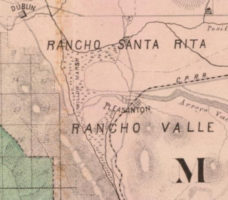
Tulare Lake was a large, shallow lake in eastern Amador Valley, surrounded by Willow Marsh. Tule rushes and willow trees once lined the marshes and sloughs of its shores. Drainage alterations starting in the 19th century have since reduced the marsh to the Arroyo de la Laguna, and the city of Pleasanton has since expanded across what was once marshland. Such rapid developments have led to tricky seasonal flow variations in Niles Canyon.
Neary Lagoon is a small lagoon located in the Lower Westside neighborhood of Santa Cruz, California. The lagoon is protected within Neary Lagoon Park, which serves as both a municipal park and wildlife refuge for migratory birds. The Santa Cruz Water Treatment Plant abuts the southwestern edge of the lagoon.

