Brickyard Cove

Last updated
Sailboat with the cove in background Sailboat and Brickyard.jpg
Sailboat with the cove in background

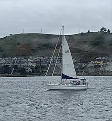
Brickyard Cove is a body of water in the Brickyard Cove neighborhood of the Point Richmond area of Richmond, California. The cove is situated between the Harbor Channel, a deepwater shipping channel that connects the San Francisco Bay with the Port of Richmond and the mainland. The cove is located between Point Potrero and Ferry Point. A marina is located in the cove and the Red Oak Victory part of Rosie the Riveter/World War II Homefront National Historic Park is docked in the western end of the cove.

The marina at Brickyard Cove Point Richmond houses (4589842386).jpg
The marina at Brickyard Cove

Brickyard Cove was once home to Richmond Brick Company. Richmond Brick Company used the area to create bricks used to build various structures in "Point Richmond" and various other structures on the East Coast. The "Bee-Hive" Kilns are still present onsite. Richmond Brick Company was owned by the "Sevy Family". Coordinates: 37°54′28″N122°23′14″W / 37.907703°N 122.387194°W / 37.907703; -122.387194 [1]

Related Research Articles

<span class="mw-page-title-main">Point Richmond, Richmond, California</span> Neighborhood in Richmond, California

Point Richmond, also sometimes referred to locally as The Point, is a neighborhood in Richmond, California, United States, near the eastern end of the Richmond-San Rafael Bridge, between Interstate 580 and the San Francisco Bay.

<span class="mw-page-title-main">Golden State Model Railroad Museum</span>

The Golden State Model Railroad Museum is an operating model railroad exhibit located in Point Richmond, California, within the boundary of the Miller/Knox Regional Shoreline park. It is located in the Brickyard Cove area and features dozens of realistic city and country scenes, with trains from different eras running on several layouts in different scales. It is on the US National Register of Historic Places.

<span class="mw-page-title-main">McLaughlin Eastshore State Park</span> State park and wildlife refuge

McLaughlin Eastshore State Park is a state park and wildlife refuge along the San Francisco Bay shoreline of the East Bay between the cities of Richmond, Albany, Berkeley, Emeryville, and Oakland. It encompasses remnant natural wetlands, restored wetlands, as well as landfill west of the Eastshore Freeway. Its shoreline is 8.5 miles (13.7 km) long, and its total area is 1,854 acres (750 ha), which includes both tidelands and uplands. Originally named just Eastshore State Park, it was renamed in October 2012 to honor the late Save the Bay founder Sylvia McLaughlin, who, along with the late Dwight Steele of Citizens for Eastshore Park, drove the establishment of the park. Prior to 2013, it was jointly managed by the California State Parks and East Bay Regional Park District (EBRPD). The state agency and EBRPD executed a 30-year agreement for EBRPD to manage the park.

Miller/Knox Regional Shoreline is a 295-acre (1.19 km2) bayside park near the Brickyard Cove neighborhood of the Point Richmond District in Richmond, California.

Campus Bay is an 87-acre (350,000 m2) property in the city of Richmond, California located off Interstate 580 (California), and situated between the San Francisco Bay, the Richmond Annex, and Point Isabel neighborhoods. The area receives its name from its proximity to the UC Berkeley Richmond Field Station.

<span class="mw-page-title-main">Brickyard Cove, Richmond, California</span>

Brickyard Cove is an upscale waterfront neighborhood in Richmond, California.

<span class="mw-page-title-main">Richmond Shipyards</span> United States historic place

The four Richmond Shipyards, in the city of Richmond, California, United States, were run by Permanente Metals and part of the Kaiser Shipyards. In World War II, Richmond built more ships than any other shipyard, turning out as many as three ships in a single day. The shipyards are part of the Rosie the Riveter/World War II Home Front National Historical Park, whose Rosie the Riveter memorial honors the shipyard workers. Shipyard #3 is listed on the National Register of Historic Places and is a California Historical Landmark # 1032.

<span class="mw-page-title-main">Castro Cove</span>

Castro Cove is a "portion of the San Pablo Bay" in Richmond, California located between Point San Pablo and the confluence of Wildcat Creek into Castro Creek.

<span class="mw-page-title-main">Point San Pablo Harbor</span> Human settlement in Richmond, California, United States of America

Point San Pablo Harbor is a marina and small community at the far end of Point San Pablo in San Pablo Bay, within Richmond, in Contra Costa County, California. It is located at 1900 Stenmark Drive, Richmond CA 94801.

San Pablo Peninsula is a peninsula in western Richmond, between San Pablo Bay and San Rafael Bay, in southwestern Contra Costa County, California.

<span class="mw-page-title-main">Richmond Inner Harbor</span> Body of water in Richmond, California, United States

Richmond Inner Harbor is a deepwater body of water in Richmond, California.

Hoffman Marsh is a wetlands on San Francisco Bay in Richmond, California. The marsh has been protected within Eastshore State Park, and adjacent to Point Isabel Regional Shoreline. The marsh is an important nesting ground for wildfowl and stopping ground on the Pacific Flyway, as it is one of only a handful of undestroyed wetlands in the Bay Area. It borders Point Isabel Regional Shoreline and Interstate 80.

The Lauritzen Canal is a shipping waterway which is part of the larger Port of Richmond in Richmond, California. It was dredged out of the former expanse of the now atrophied Castro Cove wetlands of the West Richmond Watershed. It was created for shipbuilding yards in World War II. Today is serves as part of the operation of the Port of Richmond for largely petrochemical, liquid bulk, and vehicle imports.

<span class="mw-page-title-main">Año Nuevo State Marine Conservation Area</span> Marine protected area off Californias central coast

Año Nuevo State Marine Conservation Area (SMCA) is one of two adjoining marine protected areas off the coast of San Mateo and Santa Cruz Counties, on California’s central coast. The area is approximately 55 miles south of San Francisco. The SMCA is 11.07 square miles. Except for limited taking of giant kelp, all living marine resources are protected.

<span class="mw-page-title-main">Stewarts Point State Marine Reserve & Stewarts Point State Marine Conservation Area</span> Marine protected area in California

Stewarts Point State Marine Reserve (SMR) and Stewarts Point State Marine Conservation Area (SMCA) are two adjoining marine protected areas that extend offshore from about a mile south of Black Point to Fisk Mill Cove, in Sonoma County on California’s north central coast. The marine protected areas cover 25.22 square miles. Stewarts Point SMR prohibits the take of all living marine resources. Stewarts Point SMCA prohibits the take of all living marine resources, except recreational shore based take of marine aquatic plants, marine invertebrates, finfish by hook and line, surf smelt by beach net, and species authorized by Title 14 Section 28.80 by hand-held dip net.

<span class="mw-page-title-main">Duxbury Reef State Marine Conservation Area</span>

Duxbury Reef State Marine Conservation Area (SMCA) is a marine protected area located about 1 mile (2 km) west of Bolinas in Marin County on California’s north central coast. This marine protected area covers 0.66 square miles (1.7 km2). Duxbury Reef SMCA prohibits the take of all living marine resources, except the recreational take of finfish from shore only and the recreational take of abalone.

<span class="mw-page-title-main">Montara State Marine Reserve & Pillar Point State Marine Conservation Area</span>

Montara State Marine Reserve (SMR) and Pillar Point State Marine Conservation Area (SMCA) are two adjoining marine protected areas that extend offshore from Montara to Pillar Point in San Mateo County on California’s north central coast. The combined area of these marine protected areas is 18.42 square miles (47.7 km2), with 11.76 square miles (30.5 km2) in the SMR and 6.66 in the SMCA. Montara SMR prohibits the take of all living marine resources. Pillar Point SMCA prohibits the take of all living marine resources, except the recreational and commercial take of pelagic finfish by trolling or seine, the commercial or recreational take of Dungeness crab by trap and the commercial or recreational take or market squid by hand-held dip net or round haul net.

<span class="mw-page-title-main">Point Reyes State Marine Reserve & Point Reyes State Marine Conservation Area</span>

Point Reyes State Marine Reserve (SMR) and Point Reyes State Marine Conservation Area (SMCA) are two adjoining marine protected areas that extend offshore of Point Reyes Headlands and within Drakes Bay in Marin County on California’s north central coast. The combined area of these marine protected areas is 21.49 square miles, with 9.38 in the SMR, and 12.11 in the adjacent SMCA. Point Reyes SMR prohibits the take of all living marine resources. Point Reyes SMCA prohibits the take of all living marine resources, except the recreational and commercial take of Dungeness crab by pot and salmon by trolling.

<span class="mw-page-title-main">Greyhound Rock State Marine Conservation Area</span> Marine protected area in Californias central coast

Greyhound Rock State Marine Conservation Area (SMCA) is one of two adjoining marine protected areas off the coast of San Mateo County and Santa Cruz County, on California's central coast. The area is approximately 55 miles (89 km) south of San Francisco. The SMCA is 11.81 square miles (30.6 km2). Within the SMCA fishing and take of all living marine resources is prohibited except the recreational take of giant kelp, squid, salmon, and other finfish, subject to various conditions. Also permitted is the commercial take of giant kelp, salmon, and squid, subject to various conditions.

<span class="mw-page-title-main">Yerba Buena Cove</span>

Yerba Buena Cove was a cove on San Francisco Bay where the Mexican pueblo of Yerba Buena was located. It lay between Clarks Point to the north and Rincon Point to the south. The beach of the cove was set back as far as what is now Montgomery Street between Clay and Washington Streets.

References