Castro Creek

Last updated
Castro Creek
Location
Country United States
State California
Region Contra Costa County
Physical characteristics
Source 
  locationChevron USA Richmond Oil Refinery
  coordinates 37°56′15″N122°23′13″W / 37.93750°N 122.38694°W / 37.93750; -122.38694 [1]
Mouth San Pablo Bay
  coordinates
37°58′6″N122°24′26″W / 37.96833°N 122.40722°W / 37.96833; -122.40722 [1]
  elevation
0 ft (0 m) [1]
Basin features
Tributaries 
  right Wildcat Creek

Castro Creek is a creek in Richmond, California, in the western part of the city adjacent to the Chevron Oil Refinery. Wildcat Creek drains into it directly and though other Wildcat Marsh tributaries into Castro Cove of San Pablo Bay. The creek drains from the drainage basin of the surrounding area and was once part of the channel that separated the island of Point Richmond with the mainland. [2]
Contents

Name

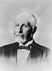
Castro Creak is named after Don Victor Castro, a Californio ranchero and politician who owned the creek, as part of his Rancho San Pablo. Don Victor Castro.jpg
Castro Creak is named after Don Víctor Castro, a Californio ranchero and politician who owned the creek, as part of his Rancho San Pablo.

The stream is waterway is named after Don Víctor Castro the owner of the area when it was Rancho San Pablo.[ citation needed ]

Description

The Chevron Richmond Refinery dumps wastewater into the creek routinely 500 yards north of the confluence with Wildcat Creek and also in a drainage. [3] Other waste may only be dumped into the creek through a drainage ditch on Castro Street during high intensity rainfall. [3] Castro Creek is a fishing, shell-fishing, and recreation area. [3] Its estuarine habitat is essential habitat for several endangered species. [3] The creek is also a fish spawning and migration center. [3] The refinery creates 5.6 million US gallons (21,000 m3) per day of byproduct refinery process water, cooling water, storm water and other wastewater which it discharges into Castro Creek, Castro Cove, Wildcat Marsh, and San Pablo Bay. [3] Castro Cove has become very polluted from 85 years of unbridled discharge of waste waters with PAHs and mercury from the Chevron Oil Refinery and is scheduled to begin cleanup efforts in summer 2007. [4]

See also

Notes

  1. 1 2 3 U.S. Geological Survey Geographic Names Information System: Castro Creek
  2. Map, TopoQuest, retrieved July 6, 2008
  3. 1 2 3 4 5 6 Monitoring Program Summary Archived 2007-09-28 at the Wayback Machine , California Coastal Water Quality Monitoring Inventory, retrieved August 31, 2007
  4. Castro Cove/Chevron Richmond, CA Archived 2008-09-17 at the Wayback Machine , National Oceanic and Atmospheric Administration (NOAA), retrieved August 1, 2007

Related Research Articles

<span class="mw-page-title-main">Richmond, California</span> City in California, United States

Richmond is a city in western Contra Costa County, California, United States. The city was incorporated on August 7, 1905, and has a city council. Located in the San Francisco Bay Area's East Bay region, Richmond borders San Pablo, Albany, El Cerrito and Pinole in addition to the unincorporated communities of North Richmond, Hasford Heights, Kensington, El Sobrante, Bayview-Montalvin Manor, Tara Hills, and East Richmond Heights, and for a short distance San Francisco on Red Rock Island in the San Francisco Bay.

<span class="mw-page-title-main">San Pablo Bay</span> Tidal estuary in the San Francisco Bay Area

San Pablo Bay is a tidal estuary that forms the northern extension of San Francisco Bay in the East Bay and North Bay regions of the San Francisco Bay Area in northern California.

<span class="mw-page-title-main">Sonoma Creek</span> Stream in California

Sonoma Creek is a 33.4-mile-long (53.8 km) stream in northern California. It is one of two principal drainages of southern Sonoma County, California, with headwaters rising in the rugged hills of Sugarloaf Ridge State Park and discharging to San Pablo Bay, the northern arm of San Francisco Bay. The watershed drained by Sonoma Creek is roughly equivalent to the wine region of Sonoma Valley, an area of about 170 square miles (440 km2). The State of California has designated the Sonoma Creek watershed as a “Critical Coastal Water Resource”. To the east of this generally rectangular watershed is the Napa River watershed, and to the west are the Petaluma River and Tolay Creek watersheds.

Point Isabel is a promontory on the eastern shore of San Francisco Bay in the Richmond Annex neighborhood of Richmond, United States.

<span class="mw-page-title-main">Laguna de Santa Rosa</span> River in California, United States

The Laguna de Santa Rosa is a 22-mile-long (35 km) wetland complex that drains a 254-square-mile (660 km2) watershed encompassing most of the Santa Rosa Plain in Sonoma County, California, United States.

<span class="mw-page-title-main">Napa Sonoma Marsh</span> Wetland in San Francisco Bay, California, USA

The Napa Sonoma Marsh is a wetland at the northern edge of San Pablo Bay, which is a northern arm of the San Francisco Bay in California, United States. This marsh has an area of 48,000 acres (190 km2), of which 13,000 acres (53 km2) are abandoned salt evaporation ponds. The United States Government has designated 13,000 acres (53 km2) in the Napa Sonoma Marsh as the San Pablo Bay National Wildlife Refuge.

Cordelia Slough is a 10.8-mile-long (17.4 km) tidal watercourse which discharges to the Suisun Slough, which in turn empties into Grizzly Bay in Solano County, California. The Suisun Slough, fed by the Green Valley Creek and Red Top Creek, provides a productive habitat for a diversity of aquatic flora and fauna. In particular steelhead migrate up Cordelia Slough to spawn in its two tributaries.

<span class="mw-page-title-main">Wildcat Creek (California)</span> River in California, United States

Wildcat Creek is a 13.4-mile-long (21.6 km) creek which flows through Wildcat Canyon situated between the Berkeley Hills and the San Pablo Ridge, emptying into San Pablo Bay in Contra Costa County, northern California.

<span class="mw-page-title-main">Garrity Creek</span> River in California, United States

Garrity Creek is a 3.0-mile-long (4.8 km) creek in Richmond, California's Hilltop neighborhood. It runs into San Pablo Bay. It is sometimes called Hilltop Creek.

<span class="mw-page-title-main">San Pablo Creek</span> River in California, United States

San Pablo Creek is an 18.7-mile-long (30.1 km) creek in Contra Costa County, California, United States, which drains the canyon or valley between the San Pablo Ridge and the Sobrante Ridge, parts of the Pacific Coast Ranges east of San Francisco Bay.

<span class="mw-page-title-main">Castro Cove</span>

Castro Cove is a "portion of the San Pablo Bay" in Richmond, California located between Point San Pablo and the confluence of Wildcat Creek into Castro Creek.

Wildcat Marsh is the wetlands delta formed by the mouth of Wildcat Creek at its confluence with Castro Creek in Richmond, California. The marsh is critical habitat for endangered species and has been contaminated and damaged by runoff from the Chevron Richmond Refinery and the city's landfill and a salvage yard. The marsh was isolated from tidal effects but restoration efforts are underway as is the closure of the landfill and cleanup of the mudflats contaminated by mercury and PAHs from the refinery.

<span class="mw-page-title-main">Hydrography of the San Francisco Bay Area</span> Waterways and watersheds draining into the bay or Pacific Ocean

The Hydrography of the San Francisco Bay Area is a complex network of watersheds, marshes, rivers, creeks, reservoirs, and bays predominantly draining into the San Francisco Bay and Pacific Ocean.

<span class="mw-page-title-main">Point San Pablo Harbor</span> Human settlement in Richmond, California, United States of America

Point San Pablo Harbor is a marina and small community at the far end of Point San Pablo in San Pablo Bay, within Richmond, in Contra Costa County, California. It is located at 1900 Stenmark Drive, Richmond CA 94801.

<span class="mw-page-title-main">Point Potrero</span>

Point Potrero is a point in San Pablo Bay forming a cape and hugging the Potrero Hills in Richmond, California.

San Pablo Peninsula is a peninsula in western Richmond, between San Pablo Bay and San Rafael Bay, in southwestern Contra Costa County, California.

<span class="mw-page-title-main">San Pablo Bay National Wildlife Refuge</span> Protected area in California, United States

San Pablo Bay National Wildlife Refuge is a 13,190-acre (53.4 km2) National Wildlife Refuge in California established in 1970. It extends along the northern shore of San Pablo Bay, from the mouth of the Petaluma River, to Tolay Creek, Sonoma Creek, and ending at Mare Island.

<span class="mw-page-title-main">Dotson Family Marsh</span>

The Dotson Family Marsh, formerly Breuner Marsh, is a 238-acre regional park on San Pablo Bay in the East San Francisco Bay Area city of Richmond, California, In 2009 the East Bay Regional Parks District acquired the Breuner Marsh site, adding it to Point Pinole Regional Shoreline. A habitat restoration plan for 60 acres of wetlands and 90 acres of California coastal prairie was subsequently approved.

<span class="mw-page-title-main">Chevron Richmond Refinery</span>

The Chevron Richmond Refinery is a 2,900-acre (1,200 ha) petroleum refinery in Richmond, California, on San Francisco Bay. It is owned and operated by Chevron Corporation and employs more than 1,200 workers, making it the city's largest employer. The refinery processes approximately 240,000 barrels (38,000 m3) of crude oil a day in the manufacture of petroleum products and other chemicals. The refinery's primary products are motor gasoline, jet fuel, diesel fuel and lubricants.

<span class="mw-page-title-main">Water pollution in the United States</span> Overview of water pollution in the United States of America

Water pollution in the United States is a growing problem that became critical in the 19th century with the development of mechanized agriculture, mining, and industry, although laws and regulations introduced in the late 20th century have improved water quality in many water bodies. Extensive industrialization and rapid urban growth exacerbated water pollution as a lack of regulation allowed for discharges of sewage, toxic chemicals, nutrients and other pollutants into surface water.