
Pyramid Lake is a reservoir formed by Pyramid Dam on Piru Creek in the eastern San Emigdio Mountains, near Castaic, Southern California. It is a part of the West Branch California Aqueduct, which is a part of the California State Water Project. Its water is fed by the system after being pumped up from the San Joaquin Valley and through the Tehachapi Mountains.
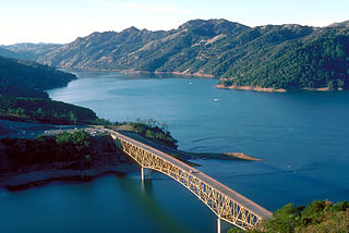
Lake Sonoma is a reservoir west of Cloverdale in northern Sonoma County, California, created by the construction of Warm Springs Dam. The lake provides water for countywide growth and development, and for recreation.

Lake Havasu is a large reservoir formed by Parker Dam on the Colorado River, on the border between San Bernardino County, California and Mohave County, Arizona. Lake Havasu City sits on the Arizonan side of the lake with its Californian counterpart of Havasu Lake directly across the lake. The reservoir has an available capacity of 619,400 acre-feet (764,000,000 m3). The concrete arch dam was built by the United States Bureau of Reclamation between 1934 and 1938. The lake's primary purpose is to store water for pumping into two aqueducts. Prior to the dam construction, the area was home to the Mojave people. The lake was named after the Mojave word for blue. In the early 19th century, it was frequented by beaver trappers. Spaniards also began to mine the areas along the river.

Nicasio Reservoir is a shallow, artificial reservoir in the Nicasio Valley region of Marin County, California, United States. It covers 845 acres (3.42 km2) and sits in a 35.9 square miles (93 km2) drainage basin. It was created by the construction of Seeger Dam on the Nicasio Creek in 1961. Seeger Dam is a 115-foot (35 m) tall, 400-foot (120 m) long earthen dam owned by the Marin Municipal Water District.
Don Pedro Reservoir, also known as Lake Don Pedro, is a reservoir formed by the construction of the New Don Pedro Dam across the Tuolumne River in Tuolumne County, California, United States.

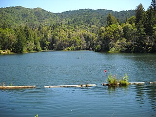
Stevens Creek Reservoir is an artificial lake located in the foothills of the Santa Cruz Mountains near Cupertino, California. A 1,063-acre (430 ha) county park surrounds the reservoir and provides limited fishing, picnicking, hiking, and horseback riding activities. Although swimming is not allowed, non-power boating is allowed for certain parts of the year. No powered boats or jet skis are allowed. All vessels must be inspected for invasive Quagga mussels prior to launch.

Lagunitas Creek is a 24 miles (39 km)-long northward-flowing stream in Marin County, California. It is critically important to the largest spawning runs of endangered coho salmon in the Central California Coast Coho salmon Evolutionary Significant Unit.

Lake McClure is a reservoir in the Sierra Nevada foothills of western Mariposa County, California.

New Melones Lake is a reservoir on the Stanislaus River in the central Sierra Nevada foothills, within Calaveras County and Tuolumne County, California.

Whiskeytown Lake is a reservoir in Shasta County in northwestern California, United States, about 8 miles (13 km) west of Redding. The lake is in the Whiskeytown Unit of the Whiskeytown-Shasta-Trinity National Recreation Area.
Lake Chabot is a man-made lake covering 317 acres (1.3 km2) in Alameda County, California, United States. Part of the lake lies within Oakland city limits, but most of it lies in unincorporated Castro Valley, just east of San Leandro. It was formed by the damming of San Leandro Creek. The lake was completed in 1875 to serve as a primary source of water for the East Bay.

Englebright Lake is an 815 acre reservoir on the Yuba River, impounded by Englebright Dam, in the Sierra Nevada, Northern California, United States. The reservoir stores 45,000 acre feet of water with nearly 24 miles of shoreline.
Kent Lake is a reservoir in western Marin County, California formed by the construction of Peters Dam across Lagunitas Creek. Built in 1954, the lake is the most recent lake of the Marin Municipal Water District, as well as the largest. It lies to the west of Alpine Lake; among the five major lakes in the area it is the only one to the west of Fairfax-Bolinas Road.
Alpine Lake is a reservoir in Marin County, California. Formed by Alpine Dam, it provides water to the Marin Municipal Water District. Below the dam lies Kent Lake. Alpine Lake is to the west of Bon Tempe Lake. Fishing is allowed, and Largemouth Bass, Smallmouth Bass, and trout can be caught. Boats and wading are not allowed on the lake.
Lake Lagunitas is a reservoir on Lagunitas Creek in Marin County, California.

Nicasio Creek is an 11.9-mile-long (19.2 km) stream in Marin County, California, United States and is the primary tributary of Lagunitas Creek, which flows, in turn, into Tomales Bay, and the Pacific Ocean. The Nicasio Reservoir, formed in 1961 by Seeger Dam, is located on this stream.

Coyote Lake is an artificial lake in Santa Clara County, California, between Morgan Hill and Gilroy.

The Lafayette Reservoir is an open-cut human-made terminal water storage reservoir owned and operated by the East Bay Municipal Utility District (EBMUD). Completed in 1933, it was intended solely as a standby water supply for EBMUD customers. EBMUD opened the reservoir for public recreation in 1966. It is located off of California State Route 24 and a mile from the Lafayette BART station, in Contra Costa County, California, United States. This all-year, day-use area is ideal for hiking, jogging, fishing, boating and picnicking. The reservoir is on the Lafayette-Orinda border. The reservoir is on a 925-acre (3.74 km2) site and holds 1.4 billion US gallons (5,300,000 m3)
The Marin Municipal Water District is the government agency that provides drinking water to southern and central Marin County, California. Chartered in 1912, it became California's first municipal water district. It serves 191,000 customers in a 147-square-mile (380 km2) area that includes ten towns and cities.


